Property Record
9800 7Th Ave, Hesperia, CA 92345
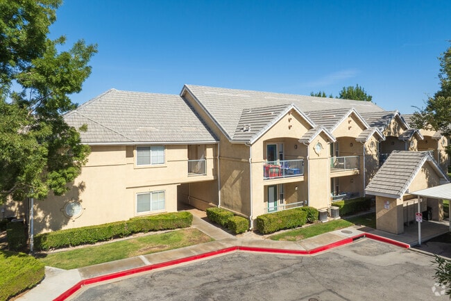


Property Detail
9800 7Th Ave
0407-221-01
HESPER1A TOWNS1TE ALL BLK 243 AND PTN 8TH AVE ADJACENT WLY AND CHESTNUT ST ADJACENT SLY VACATED BY CITY OF HESPERIA EX ST
Apartment
San Bernardino
B and X Area of moderate flood hazard, usually the area between the limits of the 100-year and 500-year floods.
California
2025
4.86 AC
2025
Outer San Bernardino County
010015
Inland Empire (California)
86,852 SF
Riverside-San Bernardino-Ontario, CA
NEARBY LISTINGS FOR SALE OR LEASE
DEMOGRAPHICS near 9800 7Th Ave
1 mile
3 mile
5 mile
2025 Total Population
8,918
63,418
160,636
2030 Population
9,043
64,324
163,153
Pop Growth 2025-2030
+ 1.40%
+ 1.43%
+ 1.57%
Average Age
35
36
37
2025 Total Households
2,625
18,441
48,990
HH Growth 2025-2030
+ 1.37%
+ 1.39%
+ 1.50%
Median Household Inc
$59,004
$69,147
$74,915
Avg Household Size
3.40
3.40
3.20
2025 Avg HH Vehicles
2.00
2.00
2.00
Median Home Value
$358,802
$388,088
$401,537
Median Year Built
1980
1985
1988
Nearby Places
Map Layers
Map Styles
 Street
 Aerial
Layers
 Traffic
 Biking
Places
Listings with unknown addresses are not visible on the map
- Restaurants
- Banks
- Shops
- Fitness
- Groceries
PUBLIC TRANSPORTATION
COMMUTER RAIL
Victorville Amtrak (Southwest Chief - Amtrak)
Drive
Walk
Distance
Victorville Amtrak (Southwest Chief - Amtrak)
16 min
8.9 mi
Freight Ports
Port of Long Beach
Drive
Walk
Distance
Port of Long Beach
112 min
93.0 mi
Nearby Properties
Address
Land Use
TOTAL SIZE
Lot Size
Zoning
Address
Land Use
TOTAL SIZE
Lot Size
Zoning
213,482 SF
19.98 AC
Address
Land Use
TOTAL SIZE
Lot Size
Zoning
158,417 SF
9.66 AC
Address
Land Use
TOTAL SIZE
Lot Size
Zoning
174,855 SF
15.46 AC
Address
Land Use
TOTAL SIZE
Lot Size
Zoning
107,746 SF
9.99 AC
Address
Land Use
TOTAL SIZE
Lot Size
Zoning
142,661 SF
14.21 AC
Address
Land Use
TOTAL SIZE
Lot Size
Zoning
79,477 SF
4.70 AC
Address
Land Use
TOTAL SIZE
Lot Size
Zoning
80,080 SF
4.88 AC
Address
Land Use
TOTAL SIZE
Lot Size
Zoning
119,525 SF
6.42 AC
Address
Land Use
TOTAL SIZE
Lot Size
Zoning
125,694 SF
10.51 AC
Address
Land Use
TOTAL SIZE
Lot Size
Zoning
65,440 SF
12.70 AC
Address
Land Use
TOTAL SIZE
Lot Size
Zoning
127,502 SF
9.32 AC
Address
Land Use
TOTAL SIZE
Lot Size
Zoning
41,249 SF
4.84 AC
Address
Land Use
TOTAL SIZE
Lot Size
Zoning
98,624 SF
8.23 AC
Address
Land Use
TOTAL SIZE
Lot Size
Zoning
59,841 SF
3.99 AC
Address
Land Use
TOTAL SIZE
Lot Size
Zoning
102,120 SF
11 AC
Address
Land Use
TOTAL SIZE
Lot Size
Zoning
70,023 SF
4.52 AC
Address
Land Use
TOTAL SIZE
Lot Size
Zoning
69,000 SF
3.17 AC
Address
Land Use
TOTAL SIZE
Lot Size
Zoning
152,482 SF
14.72 AC
R3
Address
Land Use
TOTAL SIZE
Lot Size
Zoning
29,988 SF
3.21 AC
Address
Land Use
TOTAL SIZE
Lot Size
Zoning
41,640 SF
4.06 AC
Address
Land Use
TOTAL SIZE
Lot Size
Zoning
36,231 SF
3.71 AC
Address
Land Use
TOTAL SIZE
Lot Size
Zoning
60,760 SF
5.35 AC
Address
Land Use
TOTAL SIZE
Lot Size
Zoning
82,584 SF
4.91 AC
Address
Land Use
TOTAL SIZE
Lot Size
Zoning
78,412 SF
4 AC
Address
Land Use
TOTAL SIZE
Lot Size
Zoning
37,601 SF
11.80 AC
Address
Land Use
TOTAL SIZE
Lot Size
Zoning
54,134 SF
5.10 AC
Address
Land Use
TOTAL SIZE
Lot Size
Zoning
35,290 SF
6.20 AC
Address
Land Use
TOTAL SIZE
Lot Size
Zoning
97,236 SF
3.91 AC
Address
Land Use
TOTAL SIZE
Lot Size
Zoning
The World's #1 Commercial Real Estate Marketplace
Connect with us
© 2026 CoStar Group
The information above has been obtained from sources believed reliable. While we do not doubt its accuracy we have not verified it and make no guarantee, warranty or representation about it. It is your responsibility to independently confirm its accuracy and completeness. Any projections, opinions, assumptions, or estimates used are for example only and do not represent the current or future performance of the property. The value of this transaction to you depends on tax and other factors which should be evaluated by your tax, financial, and legal advisors. You and your advisors should conduct a careful, independent investigation of the property to determine to your satisfaction the suitability of the property for your needs.