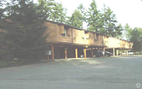
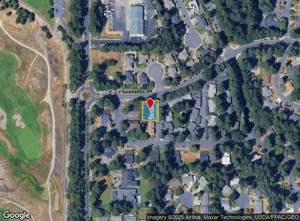
Property Record
9801 52Nd St W, University Place, WA 98467
NEARBY LISTINGS FOR SALE OR LEASE
Property Detail
9801 52Nd St W
Seattle-Tacoma-Bellevue, WA
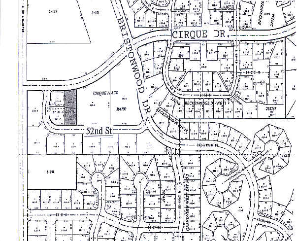
Cirque Place
304100-0094
SECTION 21 TOWNSHIP 20 RANGE 02 QUARTER 22 CIRQUE PLACE: CIRQUE PLACE L 4 OF SHORT PLAT 83-10-31-0181 EASE & RESTRICTIONS OF RECORD NE OF NW 21-20-02E APPROX 9057 SQ FT OUT OF 009-0 SEG T-0893 PP ES
Quadruplex
Pierce
X
Washington
53053C0280E
4
2024
0.21 AC
2025
University Place
072315
Seattle/Puget Sound
3,895 SF
DEMOGRAPHICS near 9801 52Nd St W
1 Mile
3 Mile
5 Mile
2024 Total Population
6,550
67,603
171,333
2029 Population
6,722
69,772
176,855
Pop Growth 2024-2029
+ 2.63%
+ 3.21%
+ 3.22%
Average Age
41
41
40
2024 Total Households
2,405
27,115
70,322
HH Growth 2024-2029
+ 2.66%
+ 3.31%
+ 3.34%
Median Household Inc
$105,855
$85,709
$78,022
Avg Household Size
2.60
2.40
2.40
2024 Avg HH Vehicles
2.00
2.00
2.00
Median Home Value
$556,201
$505,448
$467,861
Median Year Built
1973
1977
1976
Nearby Places
Map Layers
Map Styles
 Street
 Aerial
- Restaurants
- Banks
- Shops
- Fitness
- Groceries
PUBLIC TRANSPORTATION
COMMUTER RAIL
DRIVE
WALK
Distance
10 min
4.5 mi
DRIVE
WALK
Distance
17 min
7.2 mi
AIRPORT
Seattle-Tacoma International
DRIVE
WALK
Distance
Seattle-Tacoma International
49 min
29.5 mi
Freight Ports
Port of Tacoma
DRIVE
WALK
Distance
Port of Tacoma
22 min
11.1 mi
Nearby Properties
Address
Land Use
TOTAL SIZE
Lot Size
Zoning
Address
Land Use
TOTAL SIZE
Lot Size
Zoning
1,379,695 SF
215.71 AC
LKWD
Address
Land Use
TOTAL SIZE
Lot Size
Zoning
509,712 SF
70.20 AC
PI
Address
Land Use
TOTAL SIZE
Lot Size
Zoning
12,075 SF
254.10 AC
LKWD
Address
Land Use
TOTAL SIZE
Lot Size
Zoning
87,528 SF
224.76 AC
R1
Address
Land Use
TOTAL SIZE
Lot Size
Zoning
412,549 SF
56.87 AC
R1
Address
Land Use
TOTAL SIZE
Lot Size
Zoning
222,641 SF
15.41 AC
R4L
Address
Land Use
TOTAL SIZE
Lot Size
Zoning
8,177 SF
343.30 AC
R1
Address
Land Use
TOTAL SIZE
Lot Size
Zoning
244,143 SF
11.79 AC
MF3
Address
Land Use
TOTAL SIZE
Lot Size
Zoning
149,844 SF
11.50 AC
MF
Address
Land Use
TOTAL SIZE
Lot Size
Zoning
254,934 SF
5.02 AC
MF
Address
Land Use
TOTAL SIZE
Lot Size
Zoning
149,364 SF
35.69 AC
PI
Address
Land Use
TOTAL SIZE
Lot Size
Zoning
150,896 SF
11.63 AC
R3
Address
Land Use
TOTAL SIZE
Lot Size
Zoning
117,608 SF
10.11 AC
R3
Address
Land Use
TOTAL SIZE
Lot Size
Zoning
133,660 SF
6.79 AC
MF
Address
Land Use
TOTAL SIZE
Lot Size
Zoning
187,937 SF
25 AC
C3
Address
Land Use
TOTAL SIZE
Lot Size
Zoning
112,810 SF
5.16 AC
MF3
Address
Land Use
TOTAL SIZE
Lot Size
Zoning
135,891 SF
12.40 AC
P/QP
Address
Land Use
TOTAL SIZE
Lot Size
Zoning
102,123 SF
13.87 AC
OSR1
Address
Land Use
TOTAL SIZE
Lot Size
Zoning
128,511 SF
6.28 AC
MF3
Address
Land Use
TOTAL SIZE
Lot Size
Zoning
162,986 SF
10.50 AC
MF3
Address
Land Use
TOTAL SIZE
Lot Size
Zoning
122,872 SF
5.34 AC
MFH
Address
Land Use
TOTAL SIZE
Lot Size
Zoning
136,644 SF
7.87 AC
R-20
Address
Land Use
TOTAL SIZE
Lot Size
Zoning
76,388 SF
7.87 AC
MU
Address
Land Use
TOTAL SIZE
Lot Size
Zoning
106,175 SF
0.36 AC
UP
Address
Land Use
TOTAL SIZE
Lot Size
Zoning
103,717 SF
6.66 AC
R1
Address
Land Use
TOTAL SIZE
Lot Size
Zoning
192,020 SF
16.79 AC
MF
Address
Land Use
TOTAL SIZE
Lot Size
Zoning
88,308 SF
5.69 AC
MFH
Address
Land Use
TOTAL SIZE
Lot Size
Zoning
92,941 SF
7.14 AC
MF3
Address
Land Use
TOTAL SIZE
Lot Size
Zoning
134,804 SF
10.29 AC
NC
Address
Land Use
TOTAL SIZE
Lot Size
Zoning
79,792 SF
7.55 AC
MFH
The World's #1 Commercial Real Estate Marketplace
Connect with us
© 2025 CoStar Group
The information above has been obtained from sources believed reliable. While we do not doubt its accuracy we have not verified it and make no guarantee, warranty or representation about it. It is your responsibility to independently confirm its accuracy and completeness. Any projections, opinions, assumptions, or estimates used are for example only and do not represent the current or future performance of the property. The value of this transaction to you depends on tax and other factors which should be evaluated by your tax, financial, and legal advisors. You and your advisors should conduct a careful, independent investigation of the property to determine to your satisfaction the suitability of the property for your needs.