Property Record
9802 Mcpherson Rd, Laredo, TX 78045
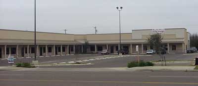

Property Detail
9802 Mcpherson Rd
242081
LOT 1 & 2 BLK 1 SAN ISIDRO/MCPHERSON IV CANTERA COURT
Commercialnec
Webb
B1
Texas
B and X Area of moderate flood hazard, usually the area between the limits of the 100-year and 500-year floods.
1,2
2024
1.91 AC
2025
Texas South Area
001723
Other Market Areas
45,579 SF
Laredo, TX
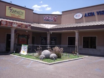
NEARBY LISTINGS FOR SALE OR LEASE
DEMOGRAPHICS near 9802 Mcpherson Rd
1 mile
3 mile
5 mile
2025 Total Population
15,006
73,997
120,068
2030 Population
15,412
75,757
122,840
Pop Growth 2025-2030
+ 2.71%
+ 2.38%
+ 2.31%
Average Age
36
35
36
2025 Total Households
4,888
23,191
37,318
HH Growth 2025-2030
+ 2.99%
+ 2.63%
+ 2.52%
Median Household Inc
$81,456
$84,799
$74,631
Avg Household Size
3.00
3.20
3.10
2025 Avg HH Vehicles
2.00
2.00
2.00
Median Home Value
$254,594
$269,115
$251,097
Median Year Built
2002
2002
1998
Nearby Places
Map Layers
Map Styles
 Street
 Aerial
Transit
 Traffic
 Biking
Places
Listings with unknown addresses are not visible on the map
- Restaurants
- Banks
- Shops
- Fitness
- Groceries
PUBLIC TRANSPORTATION
AIRPORT
Laredo International
Drive
Walk
Distance
Laredo International
12 min
7.6 mi
Freight Ports
Port of Corpus Christi
Drive
Walk
Distance
Port of Corpus Christi
168 min
146.6 mi
SALE & LEASE HISTORY
LISTING DATE
SALE/LEASE

Oct 19, 2016
For Lease
Nearby Properties
Address
Land Use
TOTAL SIZE
Lot Size
Zoning
Address
Land Use
TOTAL SIZE
Lot Size
Zoning
430,587 SF
30 AC
R1
Address
Land Use
TOTAL SIZE
Lot Size
Zoning
251,512 SF
57.32 AC
B4
Address
Land Use
TOTAL SIZE
Lot Size
Zoning
337,607 SF
45.06 AC
R1
Address
Land Use
TOTAL SIZE
Lot Size
Zoning
255,819 SF
50 AC
R1
Address
Land Use
TOTAL SIZE
Lot Size
Zoning
436,814 SF
27.66 AC
Address
Land Use
TOTAL SIZE
Lot Size
Zoning
206,224 SF
20.03 AC
R1
Address
Land Use
TOTAL SIZE
Lot Size
Zoning
649,220 SF
38.29 AC
M1
Address
Land Use
TOTAL SIZE
Lot Size
Zoning
562,944 SF
30 AC
M1
Address
Land Use
TOTAL SIZE
Lot Size
Zoning
370,800 SF
40.09 AC
Address
Land Use
TOTAL SIZE
Lot Size
Zoning
521,026 SF
30 AC
M1
Address
Land Use
TOTAL SIZE
Lot Size
Zoning
164,276 SF
43.92 AC
Address
Land Use
TOTAL SIZE
Lot Size
Zoning
286,008 SF
37.30 AC
Address
Land Use
TOTAL SIZE
Lot Size
Zoning
109,695 SF
3.73 AC
M1
Address
Land Use
TOTAL SIZE
Lot Size
Zoning
194,520 SF
11.18 AC
B3
Address
Land Use
TOTAL SIZE
Lot Size
Zoning
254,594 SF
11.84 AC
Address
Land Use
TOTAL SIZE
Lot Size
Zoning
192,203 SF
22.01 AC
B4
Address
Land Use
TOTAL SIZE
Lot Size
Zoning
136,981 SF
10.01 AC
Address
Land Use
TOTAL SIZE
Lot Size
Zoning
218,415 SF
13.41 AC
R3
Address
Land Use
TOTAL SIZE
Lot Size
Zoning
203,922 SF
11 AC
R2
Address
Land Use
TOTAL SIZE
Lot Size
Zoning
122,752 SF
17.16 AC
R2
Address
Land Use
TOTAL SIZE
Lot Size
Zoning
170,632 SF
8.03 AC
B3
Address
Land Use
TOTAL SIZE
Lot Size
Zoning
257,516 SF
21.94 AC
Address
Land Use
TOTAL SIZE
Lot Size
Zoning
158,728 SF
7.89 AC
Address
Land Use
TOTAL SIZE
Lot Size
Zoning
101,034 SF
19.79 AC
Address
Land Use
TOTAL SIZE
Lot Size
Zoning
243,399 SF
15.50 AC
Address
Land Use
TOTAL SIZE
Lot Size
Zoning
246,003 SF
24.32 AC
Address
Land Use
TOTAL SIZE
Lot Size
Zoning
100,598 SF
26.22 AC
Address
Land Use
TOTAL SIZE
Lot Size
Zoning
118,124 SF
11.30 AC
R1A
Address
Land Use
TOTAL SIZE
Lot Size
Zoning
95,769 SF
11.81 AC
Address
Land Use
TOTAL SIZE
Lot Size
Zoning
176,926 SF
8.70 AC
R2
The World's #1 Commercial Real Estate Marketplace
Connect with us
© 2026 CoStar Group
The information above has been obtained from sources believed reliable. While we do not doubt its accuracy we have not verified it and make no guarantee, warranty or representation about it. It is your responsibility to independently confirm its accuracy and completeness. Any projections, opinions, assumptions, or estimates used are for example only and do not represent the current or future performance of the property. The value of this transaction to you depends on tax and other factors which should be evaluated by your tax, financial, and legal advisors. You and your advisors should conduct a careful, independent investigation of the property to determine to your satisfaction the suitability of the property for your needs.