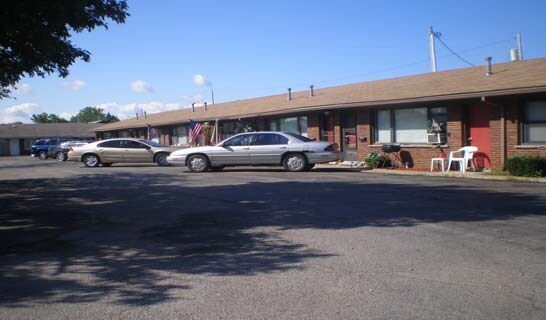
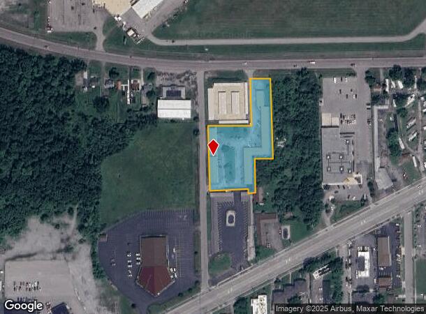
Property Record
9807 Porter Rd, Niagara Falls, NY 14304
NEARBY LISTINGS FOR SALE OR LEASE
-
-
View all Niagara Falls listings for sale on LoopNet.com
Property Detail
9807 Porter Rd
291100-146-019-0003-007-022
TM 621 LOT PT 981 411
Apartment
Niagara
X
New York
36063C0327E
7.022
2025
1.70 AC
2024
Greater Niagara Falls
022500
Buffalo/Niagara Falls
13,224 SF
Buffalo-Cheektowaga-Niagara Falls, NY
DEMOGRAPHICS near 9807 Porter Rd
1 Mile
3 Mile
5 Mile
2024 Total Population
6,238
30,426
78,659
2029 Population
6,173
30,004
77,723
Pop Growth 2024-2029
(1.04%)
(1.39%)
(1.19%)
Average Age
45
44
42
2024 Total Households
3,019
13,784
34,033
HH Growth 2024-2029
(1.09%)
(1.39%)
(1.28%)
Median Household Inc
$51,795
$61,023
$59,834
Avg Household Size
2.00
2.20
2.20
2024 Avg HH Vehicles
1.00
2.00
2.00
Median Home Value
$136,712
$155,989
$156,861
Median Year Built
1966
1959
1956
Nearby Places
- Restaurants
- Banks
- Shops
- Fitness
- Groceries
PUBLIC TRANSPORTATION
COMMUTER RAIL
Niagara Falls Station (Toronto - New York - VIA Rail)
DRIVE
WALK
Distance
Niagara Falls Station (Toronto - New York - VIA Rail)
11 min
5.7 mi
Niagara Falls Amtrak Station (Empire Service - Amtrak, Maple Leaf - Amtrak)
DRIVE
WALK
Distance
Niagara Falls Amtrak Station (Empire Service - Amtrak, Maple Leaf - Amtrak)
11 min
6.0 mi
AIRPORT
Niagara Falls International
DRIVE
WALK
Distance
Niagara Falls International
2 min
0.8 mi
Buffalo Niagara International
DRIVE
WALK
Distance
Buffalo Niagara International
33 min
18.7 mi
Freight Ports
Port of Toledo
DRIVE
WALK
Distance
Port of Toledo
372 min
302.7 mi
Nearby Properties
Address
Land Use
TOTAL SIZE
Lot Size
Zoning
Address
Land Use
TOTAL SIZE
Lot Size
Zoning
22.40 AC
INS
Address
Land Use
TOTAL SIZE
Lot Size
Zoning
3,600 SF
72.50 AC
Address
Land Use
TOTAL SIZE
Lot Size
Zoning
410,860 SF
35.20 AC
05 - COMME
Address
Land Use
TOTAL SIZE
Lot Size
Zoning
0.30 AC
R1-C
Address
Land Use
TOTAL SIZE
Lot Size
Zoning
160.52 AC
06 - INDUS
Address
Land Use
TOTAL SIZE
Lot Size
Zoning
17,941 SF
4.41 AC
OS
Address
Land Use
TOTAL SIZE
Lot Size
Zoning
58,226 SF
16.40 AC
Address
Land Use
TOTAL SIZE
Lot Size
Zoning
36.90 AC
06 - INDUS
Address
Land Use
TOTAL SIZE
Lot Size
Zoning
240,000 SF
35.50 AC
05 - COMME
Address
Land Use
TOTAL SIZE
Lot Size
Zoning
325.10 AC
06 - INDUS
Address
Land Use
TOTAL SIZE
Lot Size
Zoning
211,484 SF
18.30 AC
C3
Address
Land Use
TOTAL SIZE
Lot Size
Zoning
36,120 SF
83.58 AC
I1
Address
Land Use
TOTAL SIZE
Lot Size
Zoning
10,647 SF
14 AC
C3
Address
Land Use
TOTAL SIZE
Lot Size
Zoning
33.14 AC
C3
Address
Land Use
TOTAL SIZE
Lot Size
Zoning
6,369 SF
12.58 AC
C3
Address
Land Use
TOTAL SIZE
Lot Size
Zoning
117,095 SF
8.91 AC
C3
Address
Land Use
TOTAL SIZE
Lot Size
Zoning
1,200 SF
49.80 AC
05 - COMME
Address
Land Use
TOTAL SIZE
Lot Size
Zoning
1,040 SF
592.10 AC
OS
Address
Land Use
TOTAL SIZE
Lot Size
Zoning
131,133 SF
14.60 AC
05 - COMME
Address
Land Use
TOTAL SIZE
Lot Size
Zoning
101,390 SF
12.16 AC
C3
Address
Land Use
TOTAL SIZE
Lot Size
Zoning
8.40 AC
Address
Land Use
TOTAL SIZE
Lot Size
Zoning
125.33 AC
C1-A
Address
Land Use
TOTAL SIZE
Lot Size
Zoning
Address
Land Use
TOTAL SIZE
Lot Size
Zoning
134,148 SF
2.90 AC
C1-A
Address
Land Use
TOTAL SIZE
Lot Size
Zoning
110,668 SF
11.70 AC
C3
Address
Land Use
TOTAL SIZE
Lot Size
Zoning
136,218 SF
7.70 AC
R1-C
Address
Land Use
TOTAL SIZE
Lot Size
Zoning
134.90 AC
02
Address
Land Use
TOTAL SIZE
Lot Size
Zoning
30,315 SF
14 AC
Address
Land Use
TOTAL SIZE
Lot Size
Zoning
12,558 SF
3.23 AC
R1-A
Address
Land Use
TOTAL SIZE
Lot Size
Zoning
57,680 SF
7.64 AC
C3
The World's #1 Commercial Real Estate Marketplace
Connect with us
© 2025 CoStar Group
The information above has been obtained from sources believed reliable. While we do not doubt its accuracy we have not verified it and make no guarantee, warranty or representation about it. It is your responsibility to independently confirm its accuracy and completeness. Any projections, opinions, assumptions, or estimates used are for example only and do not represent the current or future performance of the property. The value of this transaction to you depends on tax and other factors which should be evaluated by your tax, financial, and legal advisors. You and your advisors should conduct a careful, independent investigation of the property to determine to your satisfaction the suitability of the property for your needs.