Property Record
981 Industrial Park Dr, Marietta, GA 30062
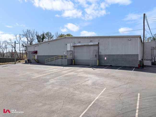
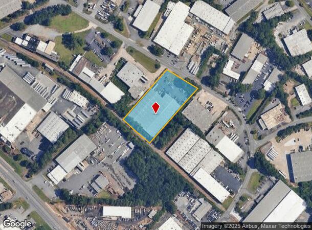
This Property Is For Sale
Current Lease Availabilities
NEARBY LISTINGS FOR SALE OR LEASE
Property Detail
981 Industrial Park Dr
Warehouse
Cobb
X
Georgia
13067C0106J
2.30 AC
2025
SE Cobb Cnty/Marietta
2025
Atlanta
030508
Atlanta-Sandy Springs-Roswell, GA
52,155 SF
16-1000-0-020-0
DEMOGRAPHICS near 981 Industrial Park Dr
1 Mile
3 Mile
5 Mile
2024 Total Population
5,157
66,511
183,808
2029 Population
5,275
67,907
187,704
Pop Growth 2024-2029
+ 2.29%
+ 2.10%
+ 2.12%
Average Age
38
38
38
2024 Total Households
1,960
27,025
71,276
HH Growth 2024-2029
+ 2.40%
+ 2.11%
+ 2.15%
Median Household Inc
$64,907
$72,897
$79,355
Avg Household Size
2.50
2.30
2.40
2024 Avg HH Vehicles
2.00
2.00
2.00
Median Home Value
$343,143
$350,920
$350,094
Median Year Built
1973
1985
1986
Nearby Places
- Restaurants
- Banks
- Shops
- Fitness
- Groceries
PUBLIC TRANSPORTATION
AIRPORT
Hartsfield - Jackson Atlanta International
DRIVE
WALK
Distance
Hartsfield - Jackson Atlanta International
41 min
28.8 mi
Nearby Properties
Address
Land Use
TOTAL SIZE
Lot Size
Zoning
Address
Land Use
TOTAL SIZE
Lot Size
Zoning
379,750 SF
11.14 AC
Address
Land Use
TOTAL SIZE
Lot Size
Zoning
578,456 SF
60 AC
RM-12
Address
Land Use
TOTAL SIZE
Lot Size
Zoning
449,337 SF
53.52 AC
RM-12
Address
Land Use
TOTAL SIZE
Lot Size
Zoning
507,196 SF
67.83 AC
RM-12
Address
Land Use
TOTAL SIZE
Lot Size
Zoning
326,166 SF
40 AC
RM-12/WS
Address
Land Use
TOTAL SIZE
Lot Size
Zoning
385,954 SF
31 AC
RM-12
Address
Land Use
TOTAL SIZE
Lot Size
Zoning
304,376 SF
19.86 AC
RM-12/WS
Address
Land Use
TOTAL SIZE
Lot Size
Zoning
494,076 SF
33.30 AC
PRD MF
Address
Land Use
TOTAL SIZE
Lot Size
Zoning
300,105 SF
43.12 AC
RM-8
Address
Land Use
TOTAL SIZE
Lot Size
Zoning
245,066 SF
15.41 AC
UC
Address
Land Use
TOTAL SIZE
Lot Size
Zoning
272,064 SF
22.59 AC
RM-12
Address
Land Use
TOTAL SIZE
Lot Size
Zoning
183,262 SF
19.35 AC
RM-12
Address
Land Use
TOTAL SIZE
Lot Size
Zoning
8,000 SF
9.57 AC
PRD MF
Address
Land Use
TOTAL SIZE
Lot Size
Zoning
99,863 SF
21.90 AC
UC
Address
Land Use
TOTAL SIZE
Lot Size
Zoning
284,832 SF
19.56 AC
PRD MF
Address
Land Use
TOTAL SIZE
Lot Size
Zoning
243,574 SF
40.05 AC
RM-8
Address
Land Use
TOTAL SIZE
Lot Size
Zoning
129,168 SF
0.82 AC
OI
Address
Land Use
TOTAL SIZE
Lot Size
Zoning
285,846 SF
19.21 AC
PRD MF
Address
Land Use
TOTAL SIZE
Lot Size
Zoning
284,213 SF
19.85 AC
RM-12
Address
Land Use
TOTAL SIZE
Lot Size
Zoning
226,769 SF
13.40 AC
RM-16
Address
Land Use
TOTAL SIZE
Lot Size
Zoning
281,097 SF
31.52 AC
GC
Address
Land Use
TOTAL SIZE
Lot Size
Zoning
240,628 SF
30.90 AC
RM-8
Address
Land Use
TOTAL SIZE
Lot Size
Zoning
222,906 SF
18.96 AC
RM-12
Address
Land Use
TOTAL SIZE
Lot Size
Zoning
198,488 SF
16.79 AC
RM-12
Address
Land Use
TOTAL SIZE
Lot Size
Zoning
143,362 SF
1.61 AC
OI
Address
Land Use
TOTAL SIZE
Lot Size
Zoning
254,242 SF
17.48 AC
RM-8
Address
Land Use
TOTAL SIZE
Lot Size
Zoning
251,598 SF
18.77 AC
GC
Address
Land Use
TOTAL SIZE
Lot Size
Zoning
325,227 SF
22.42 AC
RM-12
Address
Land Use
TOTAL SIZE
Lot Size
Zoning
13.17 AC
LI
Address
Land Use
TOTAL SIZE
Lot Size
Zoning
180,508 SF
21.88 AC
RM-8
The World's #1 Commercial Real Estate Marketplace
Connect with us
© 2025 CoStar Group
The information above has been obtained from sources believed reliable. While we do not doubt its accuracy we have not verified it and make no guarantee, warranty or representation about it. It is your responsibility to independently confirm its accuracy and completeness. Any projections, opinions, assumptions, or estimates used are for example only and do not represent the current or future performance of the property. The value of this transaction to you depends on tax and other factors which should be evaluated by your tax, financial, and legal advisors. You and your advisors should conduct a careful, independent investigation of the property to determine to your satisfaction the suitability of the property for your needs.