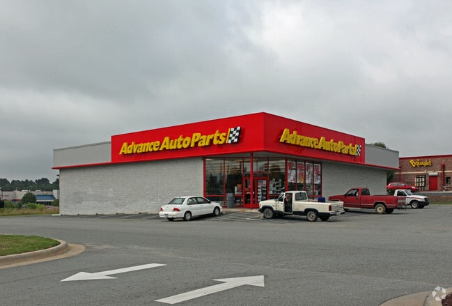
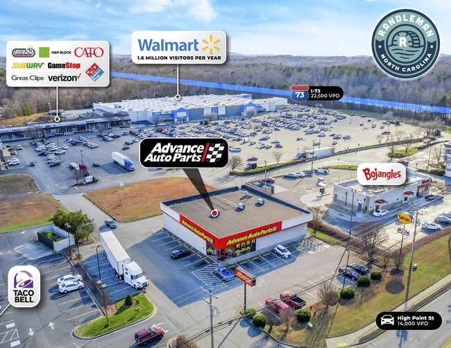
Property Record
981 High Point St, Randleman, NC 27317

Property Detail
981 High Point St
7755-65-0059
JR DEVELOPERS LLC;L1 PL:PB93-PG8
Storebuilding
Randolph
B-2
North Carolina
B and X Area of moderate flood hazard, usually the area between the limits of the 100-year and 500-year floods.
1
2025
0.75 AC
2025
NE Randolph County
031401
Greensboro/Winston-Salem
7,581 SF
Greensboro-High Point, NC
NEARBY LISTINGS FOR SALE OR LEASE
-
-
View all Randleman listings for sale on LoopNet.com
DEMOGRAPHICS near 981 High Point St
1 mile
3 mile
5 mile
2025 Total Population
1,629
9,613
23,811
2030 Population
1,659
9,796
24,371
Pop Growth 2025-2030
+ 1.84%
+ 1.90%
+ 2.35%
Average Age
40
41
40
2025 Total Households
672
3,861
9,484
HH Growth 2025-2030
+ 1.93%
+ 1.97%
+ 2.44%
Median Household Inc
$42,100
$64,262
$54,402
Avg Household Size
2.40
2.50
2.50
2025 Avg HH Vehicles
2.00
2.00
2.00
Median Home Value
$194,402
$215,738
$216,112
Median Year Built
1963
1978
1988
Nearby Places
Map Layers
Map Styles
 Street
 Aerial
Transit
 Traffic
 Biking
Places
Listings with unknown addresses are not visible on the map
- Restaurants
- Banks
- Shops
- Fitness
- Groceries
PUBLIC TRANSPORTATION
AIRPORT
Piedmont Triad International
Drive
Walk
Distance
Piedmont Triad International
34 min
24.9 mi
Freight Ports
Port of Wilmington
Drive
Walk
Distance
Port of Wilmington
234 min
198.2 mi
SALE & LEASE HISTORY
LISTING DATE
SALE/LEASE

Mar 04, 2024
For Sale
Nearby Properties
Address
Land Use
TOTAL SIZE
Lot Size
Zoning
Address
Land Use
TOTAL SIZE
Lot Size
Zoning
145,020 SF
62.15 AC
I-1
Address
Land Use
TOTAL SIZE
Lot Size
Zoning
188,645 SF
28.68 AC
I-1
Address
Land Use
TOTAL SIZE
Lot Size
Zoning
226,785 SF
46.15 AC
I-1
Address
Land Use
TOTAL SIZE
Lot Size
Zoning
63,115 SF
29.70 AC
I-1
Address
Land Use
TOTAL SIZE
Lot Size
Zoning
151,525 SF
16.92 AC
B-2
Address
Land Use
TOTAL SIZE
Lot Size
Zoning
201,008 SF
15.65 AC
I-1
Address
Land Use
TOTAL SIZE
Lot Size
Zoning
125,738 SF
27.16 AC
I2
Address
Land Use
TOTAL SIZE
Lot Size
Zoning
151,574 SF
23.07 AC
I-1
Address
Land Use
TOTAL SIZE
Lot Size
Zoning
7,000 SF
21.83 AC
B-1
Address
Land Use
TOTAL SIZE
Lot Size
Zoning
93,000 SF
22.74 AC
I-1
Address
Land Use
TOTAL SIZE
Lot Size
Zoning
193.20 AC
I-1
Address
Land Use
TOTAL SIZE
Lot Size
Zoning
16,540 SF
11.38 AC
I2
Address
Land Use
TOTAL SIZE
Lot Size
Zoning
98,400 SF
35.71 AC
I-1
Address
Land Use
TOTAL SIZE
Lot Size
Zoning
23,822 SF
7.09 AC
I-1
Address
Land Use
TOTAL SIZE
Lot Size
Zoning
44,988 SF
7.86 AC
B-2
Address
Land Use
TOTAL SIZE
Lot Size
Zoning
45,724 SF
10.96 AC
B-2
Address
Land Use
TOTAL SIZE
Lot Size
Zoning
12,739 SF
3.18 AC
B-1
Address
Land Use
TOTAL SIZE
Lot Size
Zoning
21,940 SF
5.01 AC
B-2
Address
Land Use
TOTAL SIZE
Lot Size
Zoning
1,740 SF
9.80 AC
R-3
Address
Land Use
TOTAL SIZE
Lot Size
Zoning
73,189 SF
7.49 AC
I-1
Address
Land Use
TOTAL SIZE
Lot Size
Zoning
102,594 SF
9.32 AC
I-1
Address
Land Use
TOTAL SIZE
Lot Size
Zoning
6,000 SF
8.01 AC
LI-CD
Address
Land Use
TOTAL SIZE
Lot Size
Zoning
30,886 SF
4.18 AC
I-1
Address
Land Use
TOTAL SIZE
Lot Size
Zoning
18,290 SF
3.94 AC
B-2
Address
Land Use
TOTAL SIZE
Lot Size
Zoning
85,680 SF
11.51 AC
I-1
Address
Land Use
TOTAL SIZE
Lot Size
Zoning
36,864 SF
12.15 AC
I-1
Address
Land Use
TOTAL SIZE
Lot Size
Zoning
7,048 SF
7.49 AC
R-3
Address
Land Use
TOTAL SIZE
Lot Size
Zoning
81,000 SF
2.53 AC
I2
Address
Land Use
TOTAL SIZE
Lot Size
Zoning
5,969 SF
1 AC
B-2
Address
Land Use
TOTAL SIZE
Lot Size
Zoning
23,020 SF
4.48 AC
B-2
The World's #1 Commercial Real Estate Marketplace
Connect with us
© 2026 CoStar Group
The information above has been obtained from sources believed reliable. While we do not doubt its accuracy we have not verified it and make no guarantee, warranty or representation about it. It is your responsibility to independently confirm its accuracy and completeness. Any projections, opinions, assumptions, or estimates used are for example only and do not represent the current or future performance of the property. The value of this transaction to you depends on tax and other factors which should be evaluated by your tax, financial, and legal advisors. You and your advisors should conduct a careful, independent investigation of the property to determine to your satisfaction the suitability of the property for your needs.