Property Record
9814 Us Highway 311, High Point, NC 27263
NEARBY LISTINGS FOR SALE OR LEASE
Property Detail
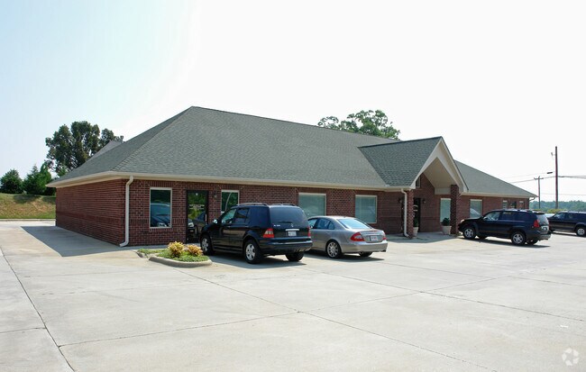
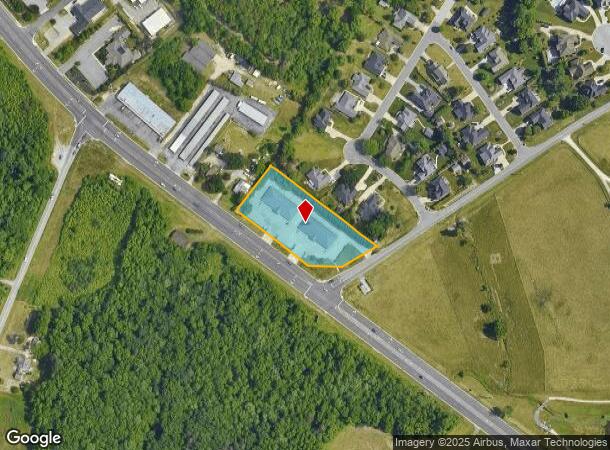
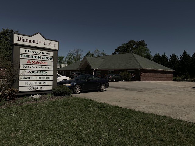
9814 Us Highway 311
7727-39-5861
Parker Place
Officebuilding
PARKER PLACE;UNNUMBERED LOT PL:PB62-PG46
X
Randolph
3710772700J
North Carolina
2025
1.61 AC
2025
NW Randolph Cnty/Archdale
031504
Greensboro/Winston-Salem
5,600 SF
Greensboro-High Point, NC
DEMOGRAPHICS near 9814 Us Highway 311
1 Mile
3 Mile
5 Mile
2024 Total Population
2,570
16,851
35,116
2029 Population
2,649
17,363
36,008
Pop Growth 2024-2029
+ 3.07%
+ 3.04%
+ 2.54%
Average Age
43
43
42
2024 Total Households
1,027
6,950
14,187
HH Growth 2024-2029
+ 3.02%
+ 3.02%
+ 2.53%
Median Household Inc
$70,173
$61,611
$57,275
Avg Household Size
2.50
2.40
2.40
2024 Avg HH Vehicles
3.00
2.00
2.00
Median Home Value
$183,129
$161,721
$154,317
Median Year Built
1984
1980
1978
Nearby Places
Map Layers
Map Styles
 Street
 Aerial
- Restaurants
- Banks
- Shops
- Fitness
- Groceries
PUBLIC TRANSPORTATION
COMMUTER RAIL
High Point Station (Piedmont - North Carolina by Train (NC Train))
DRIVE
WALK
Distance
High Point Station (Piedmont - North Carolina by Train (NC Train))
13 min
6.8 mi
AIRPORT
Piedmont Triad International
DRIVE
WALK
Distance
Piedmont Triad International
32 min
21.8 mi
Freight Ports
Port of Wilmington
DRIVE
WALK
Distance
Port of Wilmington
241 min
204.4 mi
SALE & LEASE HISTORY
LISTING DATE
SALE/LEASE

Jun 24, 2019
For Lease
Jun 12, 2024
For Lease
Jan 13, 2022
For Lease
Apr 25, 2019
For Lease
Nearby Properties
Address
Land Use
TOTAL SIZE
Lot Size
Zoning
Address
Land Use
TOTAL SIZE
Lot Size
Zoning
127,800 SF
57.35 AC
M-1
Address
Land Use
TOTAL SIZE
Lot Size
Zoning
159,944 SF
13.95 AC
RS-40
Address
Land Use
TOTAL SIZE
Lot Size
Zoning
299,394 SF
8.60 AC
M-2
Address
Land Use
TOTAL SIZE
Lot Size
Zoning
90,000 SF
15.36 AC
M-2
Address
Land Use
TOTAL SIZE
Lot Size
Zoning
7,680 SF
9.95 AC
GRD
Address
Land Use
TOTAL SIZE
Lot Size
Zoning
69,094 SF
5.47 AC
M-2
Address
Land Use
TOTAL SIZE
Lot Size
Zoning
28.20 AC
RR
Address
Land Use
TOTAL SIZE
Lot Size
Zoning
7,168 SF
7.51 AC
GRD
Address
Land Use
TOTAL SIZE
Lot Size
Zoning
73,658 SF
8.45 AC
B-1
Address
Land Use
TOTAL SIZE
Lot Size
Zoning
199,250 SF
54.80 AC
M-1
Address
Land Use
TOTAL SIZE
Lot Size
Zoning
48,913 SF
2.25 AC
B-1
Address
Land Use
TOTAL SIZE
Lot Size
Zoning
47,822 SF
5.76 AC
SU R-10
Address
Land Use
TOTAL SIZE
Lot Size
Zoning
35,620 SF
5.47 AC
M-2
Address
Land Use
TOTAL SIZE
Lot Size
Zoning
53,520 SF
5.48 AC
B-1
Address
Land Use
TOTAL SIZE
Lot Size
Zoning
8,927 SF
3.60 AC
OI
Address
Land Use
TOTAL SIZE
Lot Size
Zoning
40,275 SF
2.31 AC
B-1
Address
Land Use
TOTAL SIZE
Lot Size
Zoning
42,112 SF
6.41 AC
HB
Address
Land Use
TOTAL SIZE
Lot Size
Zoning
99,722 SF
38.11 AC
M-2
Address
Land Use
TOTAL SIZE
Lot Size
Zoning
43,328 SF
2.11 AC
B-1
Address
Land Use
TOTAL SIZE
Lot Size
Zoning
37,680 SF
1.66 AC
CD HB
Address
Land Use
TOTAL SIZE
Lot Size
Zoning
18.23 AC
R-15
Address
Land Use
TOTAL SIZE
Lot Size
Zoning
17,966 SF
4.17 AC
RBO-CD
Address
Land Use
TOTAL SIZE
Lot Size
Zoning
27,601 SF
8.28 AC
SU R-10
Address
Land Use
TOTAL SIZE
Lot Size
Zoning
22,202 SF
2.30 AC
B-1
Address
Land Use
TOTAL SIZE
Lot Size
Zoning
19,156 SF
2.33 AC
B-1
Address
Land Use
TOTAL SIZE
Lot Size
Zoning
2,880 SF
2.91 AC
B-1
Address
Land Use
TOTAL SIZE
Lot Size
Zoning
107,400 SF
9.89 AC
LI
Address
Land Use
TOTAL SIZE
Lot Size
Zoning
1.33 AC
B-1
Address
Land Use
TOTAL SIZE
Lot Size
Zoning
112,900 SF
6.39 AC
M-2
Address
Land Use
TOTAL SIZE
Lot Size
Zoning
50,200 SF
7 AC
M-2
The World's #1 Commercial Real Estate Marketplace
Connect with us
© 2025 CoStar Group
The information above has been obtained from sources believed reliable. While we do not doubt its accuracy we have not verified it and make no guarantee, warranty or representation about it. It is your responsibility to independently confirm its accuracy and completeness. Any projections, opinions, assumptions, or estimates used are for example only and do not represent the current or future performance of the property. The value of this transaction to you depends on tax and other factors which should be evaluated by your tax, financial, and legal advisors. You and your advisors should conduct a careful, independent investigation of the property to determine to your satisfaction the suitability of the property for your needs.