Property Record
982 Greentree Rd, Middletown, OH 45044
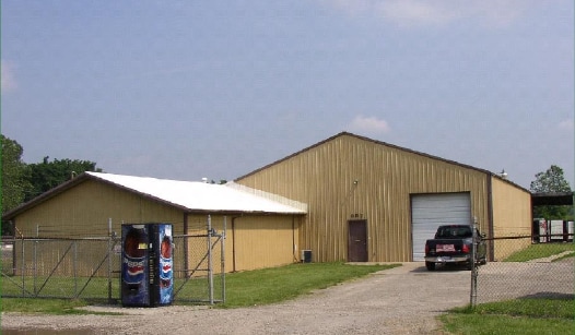

Property Detail
982 Greentree Rd
07-01-100-019
GREENTREE
Warehouse
WARREN
A Areas with a 1% annual chance of flooding and a 26% chance of flooding over the life of a 30-year mortgage.
Ohio
2024
3.16 AC
2025
Monroe/Middletown
031602
Cincinnati/Dayton
2,100 SF
Cincinnati, OH-KY-IN
NEARBY LISTINGS FOR SALE OR LEASE
DEMOGRAPHICS near 982 Greentree Rd
1 mile
3 mile
5 mile
2025 Total Population
2,686
36,434
89,087
2030 Population
2,784
37,661
92,176
Pop Growth 2025-2030
+ 3.65%
+ 3.37%
+ 3.47%
Average Age
41
41
40
2025 Total Households
1,069
14,248
34,437
HH Growth 2025-2030
+ 3.84%
+ 3.58%
+ 3.60%
Median Household Inc
$73,108
$69,461
$68,322
Avg Household Size
2.40
2.30
2.40
2025 Avg HH Vehicles
2.00
2.00
2.00
Median Home Value
$244,086
$236,673
$235,179
Median Year Built
1992
1976
1971
Nearby Places
Map Layers
Map Styles
 Street
 Aerial
Transit
 Traffic
 Biking
Places
Listings with unknown addresses are not visible on the map
- Restaurants
- Banks
- Shops
- Fitness
- Groceries
PUBLIC TRANSPORTATION
AIRPORT
James M Cox Dayton International
Drive
Walk
Distance
James M Cox Dayton International
51 min
36.7 mi
Cincinnati/Northern Kentucky International
Drive
Walk
Distance
Cincinnati/Northern Kentucky International
68 min
45.5 mi
SALE & LEASE HISTORY
LISTING DATE
SALE/LEASE

Jun 05, 2024
For Sale
Nearby Properties
Address
Land Use
TOTAL SIZE
Lot Size
Zoning
Address
Land Use
TOTAL SIZE
Lot Size
Zoning
160,701 SF
10.83 AC
Address
Land Use
TOTAL SIZE
Lot Size
Zoning
198,204 SF
360 AC
Address
Land Use
TOTAL SIZE
Lot Size
Zoning
157.32 AC
Address
Land Use
TOTAL SIZE
Lot Size
Zoning
369,922 SF
28.10 AC
Address
Land Use
TOTAL SIZE
Lot Size
Zoning
67.56 AC
Address
Land Use
TOTAL SIZE
Lot Size
Zoning
39.51 AC
Address
Land Use
TOTAL SIZE
Lot Size
Zoning
5,000 SF
60.29 AC
Address
Land Use
TOTAL SIZE
Lot Size
Zoning
1,380,095 SF
47.11 AC
Address
Land Use
TOTAL SIZE
Lot Size
Zoning
112.09 AC
Address
Land Use
TOTAL SIZE
Lot Size
Zoning
3,956 SF
186.57 AC
Address
Land Use
TOTAL SIZE
Lot Size
Zoning
99.22 AC
Address
Land Use
TOTAL SIZE
Lot Size
Zoning
9,224 SF
16.21 AC
Address
Land Use
TOTAL SIZE
Lot Size
Zoning
27,780 SF
61.49 AC
Address
Land Use
TOTAL SIZE
Lot Size
Zoning
542,679 SF
24.92 AC
Address
Land Use
TOTAL SIZE
Lot Size
Zoning
369,922 SF
28.10 AC
Address
Land Use
TOTAL SIZE
Lot Size
Zoning
201,476 SF
22.21 AC
Address
Land Use
TOTAL SIZE
Lot Size
Zoning
120,685 SF
21.52 AC
Address
Land Use
TOTAL SIZE
Lot Size
Zoning
478,217 SF
61.13 AC
Address
Land Use
TOTAL SIZE
Lot Size
Zoning
37,842 SF
13.68 AC
Address
Land Use
TOTAL SIZE
Lot Size
Zoning
612,886 SF
30.51 AC
Address
Land Use
TOTAL SIZE
Lot Size
Zoning
148,762 SF
5.01 AC
Address
Land Use
TOTAL SIZE
Lot Size
Zoning
46.86 AC
Address
Land Use
TOTAL SIZE
Lot Size
Zoning
93,289 SF
11.43 AC
Address
Land Use
TOTAL SIZE
Lot Size
Zoning
86.47 AC
ADV
Address
Land Use
TOTAL SIZE
Lot Size
Zoning
36.40 AC
Address
Land Use
TOTAL SIZE
Lot Size
Zoning
113,241 SF
7.84 AC
Address
Land Use
TOTAL SIZE
Lot Size
Zoning
485,080 SF
15.10 AC
Address
Land Use
TOTAL SIZE
Lot Size
Zoning
12,500 SF
32.38 AC
MXUC
Address
Land Use
TOTAL SIZE
Lot Size
Zoning
64.34 AC
Address
Land Use
TOTAL SIZE
Lot Size
Zoning
111,304 SF
9.77 AC
The World's #1 Commercial Real Estate Marketplace
Connect with us
© 2026 CoStar Group
The information above has been obtained from sources believed reliable. While we do not doubt its accuracy we have not verified it and make no guarantee, warranty or representation about it. It is your responsibility to independently confirm its accuracy and completeness. Any projections, opinions, assumptions, or estimates used are for example only and do not represent the current or future performance of the property. The value of this transaction to you depends on tax and other factors which should be evaluated by your tax, financial, and legal advisors. You and your advisors should conduct a careful, independent investigation of the property to determine to your satisfaction the suitability of the property for your needs.