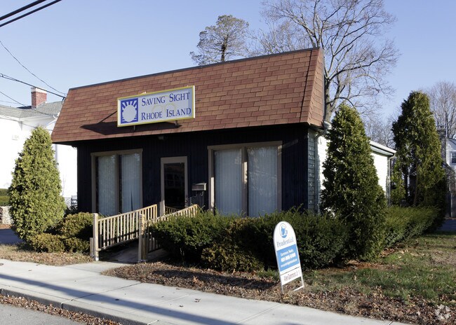
Property Record
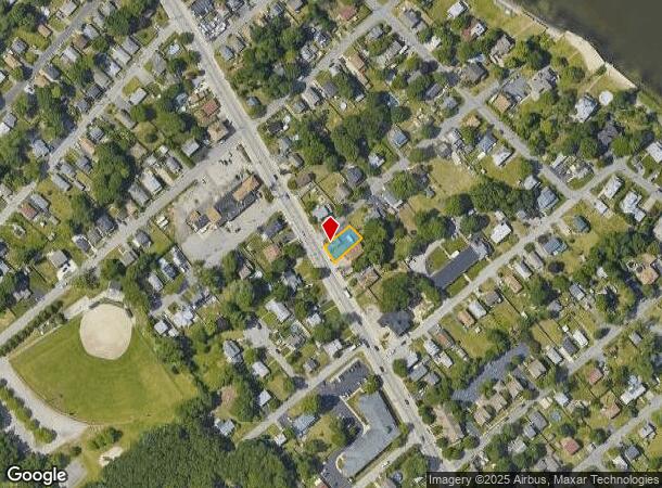
982 W Shore Rd, Warwick, RI 02889
NEARBY LISTINGS FOR SALE OR LEASE
Property Detail
982 W Shore Rd
Commercialbuilding
Kent
X
Rhode Island
44003C0132H
0.11 AC
2025
Warwick
2025
Providence
021501
Providence-Warwick, RI-MA
720 SF
WARW-000333-000298-000000
DEMOGRAPHICS near 982 W Shore Rd
1 Mile
3 Mile
5 Mile
2024 Total Population
6,945
49,310
137,882
2029 Population
7,008
49,911
138,521
Pop Growth 2024-2029
+ 0.91%
+ 1.22%
+ 0.46%
Average Age
42
44
43
2024 Total Households
2,901
20,945
57,181
HH Growth 2024-2029
+ 0.90%
+ 1.22%
+ 0.51%
Median Household Inc
$69,597
$76,170
$78,425
Avg Household Size
2.40
2.30
2.30
2024 Avg HH Vehicles
2.00
2.00
2.00
Median Home Value
$296,455
$304,964
$315,466
Median Year Built
1955
1957
1956
Nearby Places
Map Layers
Map Styles
 Street
 Aerial
- Restaurants
- Banks
- Shops
- Fitness
- Groceries
PUBLIC TRANSPORTATION
COMMUTER RAIL
Tf Green Airport (Providence/Stoughton Line - MBTA)
DRIVE
WALK
Distance
Tf Green Airport (Providence/Stoughton Line - MBTA)
8 min
4.3 mi
Providence (Providence/Stoughton Line - Massachusetts Bay Transportation Authority Commuter Rail (Purple Line))
DRIVE
WALK
Distance
Providence (Providence/Stoughton Line - Massachusetts Bay Transportation Authority Commuter Rail (Purple Line))
16 min
9.2 mi
AIRPORT
Rhode Island Tf Green International
DRIVE
WALK
Distance
Rhode Island Tf Green International
7 min
3.3 mi
Freight Ports
Port of Davisville, RI
DRIVE
WALK
Distance
Port of Davisville, RI
30 min
17.4 mi
SALE & LEASE HISTORY
LISTING DATE
SALE/LEASE

Oct 04, 2018
For Sale
Feb 01, 2019
For Lease
Nearby Properties
Address
Land Use
TOTAL SIZE
Lot Size
Zoning
Address
Land Use
TOTAL SIZE
Lot Size
Zoning
187,151 SF
29.41 AC
RE
Address
Land Use
TOTAL SIZE
Lot Size
Zoning
40,385 SF
70 AC
A40
Address
Land Use
TOTAL SIZE
Lot Size
Zoning
228,067 SF
30.74 AC
A7
Address
Land Use
TOTAL SIZE
Lot Size
Zoning
491,496 SF
46.72 AC
LI
Address
Land Use
TOTAL SIZE
Lot Size
Zoning
247,671 SF
10.78 AC
A7
Address
Land Use
TOTAL SIZE
Lot Size
Zoning
135,317 SF
27.16 AC
A10
Address
Land Use
TOTAL SIZE
Lot Size
Zoning
110,031 SF
5.07 AC
EH
Address
Land Use
TOTAL SIZE
Lot Size
Zoning
9.35 AC
C1
Address
Land Use
TOTAL SIZE
Lot Size
Zoning
73,193 SF
19.87 AC
A10
Address
Land Use
TOTAL SIZE
Lot Size
Zoning
6.58 AC
R5
Address
Land Use
TOTAL SIZE
Lot Size
Zoning
19,584 SF
A10
Address
Land Use
TOTAL SIZE
Lot Size
Zoning
24,767 SF
GB
Address
Land Use
TOTAL SIZE
Lot Size
Zoning
125,272 SF
12.48 AC
GB
Address
Land Use
TOTAL SIZE
Lot Size
Zoning
24,865 SF
A7
Address
Land Use
TOTAL SIZE
Lot Size
Zoning
5.40 AC
WB
Address
Land Use
TOTAL SIZE
Lot Size
Zoning
18,876 SF
44.45 AC
A7
Address
Land Use
TOTAL SIZE
Lot Size
Zoning
48,800 SF
78.50 AC
A15
Address
Land Use
TOTAL SIZE
Lot Size
Zoning
12,240 SF
A10
Address
Land Use
TOTAL SIZE
Lot Size
Zoning
3,987 SF
5.99 AC
GB
Address
Land Use
TOTAL SIZE
Lot Size
Zoning
20,768 SF
13.04 AC
A10
Address
Land Use
TOTAL SIZE
Lot Size
Zoning
18,032 SF
4.37 AC
A7
Address
Land Use
TOTAL SIZE
Lot Size
Zoning
67,252 SF
6.60 AC
A10
Address
Land Use
TOTAL SIZE
Lot Size
Zoning
39,041 SF
18.31 AC
GB
Address
Land Use
TOTAL SIZE
Lot Size
Zoning
79.02 AC
A7
Address
Land Use
TOTAL SIZE
Lot Size
Zoning
138.20 AC
RE
Address
Land Use
TOTAL SIZE
Lot Size
Zoning
218.86 AC
C
Address
Land Use
TOTAL SIZE
Lot Size
Zoning
23,600 SF
A10
Address
Land Use
TOTAL SIZE
Lot Size
Zoning
39,421 SF
A7
Address
Land Use
TOTAL SIZE
Lot Size
Zoning
36,047 SF
169.94 AC
OS
Address
Land Use
TOTAL SIZE
Lot Size
Zoning
55,178 SF
4.19 AC
A7
The World's #1 Commercial Real Estate Marketplace
Connect with us
© 2025 CoStar Group
The information above has been obtained from sources believed reliable. While we do not doubt its accuracy we have not verified it and make no guarantee, warranty or representation about it. It is your responsibility to independently confirm its accuracy and completeness. Any projections, opinions, assumptions, or estimates used are for example only and do not represent the current or future performance of the property. The value of this transaction to you depends on tax and other factors which should be evaluated by your tax, financial, and legal advisors. You and your advisors should conduct a careful, independent investigation of the property to determine to your satisfaction the suitability of the property for your needs.