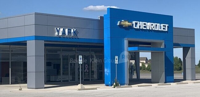
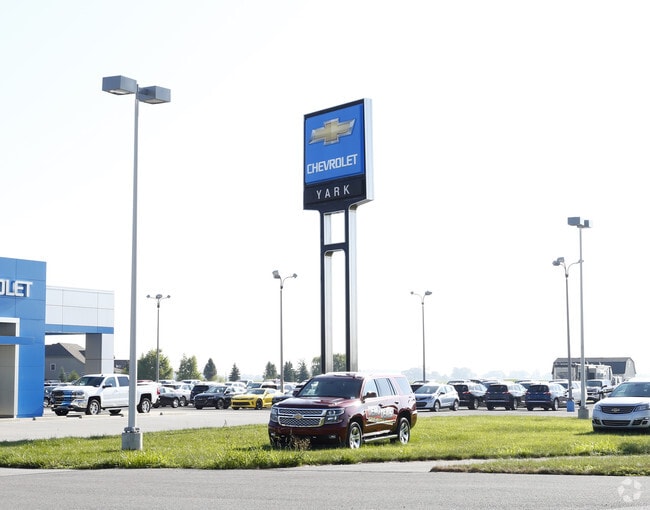
Property Record
9830 Waterville Swanton Rd, Waterville, OH 43566

Property Detail
9830 Waterville Swanton Rd
93-03380
9 6 1 NW 1/4 PT LYING N OF CEN WATERVILLE SWANTON RD & E O
Vehiclerentalsvehiclesales
LUCAS
23-C2
Ohio
B and X Area of moderate flood hazard, usually the area between the limits of the 100-year and 500-year floods.
6.17 AC
0
South/Southwest
2025
Toledo
008903
Toledo, OH
20,758 SF
NEARBY LISTINGS FOR SALE OR LEASE
-
-
View all Waterville listings for sale on LoopNet.com
DEMOGRAPHICS near 9830 Waterville Swanton Rd
1 mile
3 mile
5 mile
2025 Total Population
1,774
13,526
29,281
2030 Population
1,771
13,458
29,141
Pop Growth 2025-2030
(0.17%)
(0.50%)
(0.48%)
Average Age
40
41
43
2025 Total Households
634
4,978
11,041
HH Growth 2025-2030
(0.16%)
(0.56%)
(0.55%)
Median Household Inc
$133,244
$116,912
$118,659
Avg Household Size
2.80
2.70
2.60
2025 Avg HH Vehicles
2.00
2.00
2.00
Median Home Value
$388,920
$332,311
$342,804
Median Year Built
2006
1993
1996
Nearby Places
Map Layers
Map Styles
 Street
 Aerial
Layers
 Traffic
 Biking
Places
Listings with unknown addresses are not visible on the map
- Restaurants
- Banks
- Shops
- Fitness
- Groceries
PUBLIC TRANSPORTATION
AIRPORT
Eugene F Kranz Toledo Express
Drive
Walk
Distance
Eugene F Kranz Toledo Express
19 min
7.4 mi
Freight Ports
Port of Toledo
Drive
Walk
Distance
Port of Toledo
35 min
22.4 mi
SALE & LEASE HISTORY
LISTING DATE
SALE/LEASE

Dec 09, 2020
For Sale
Nearby Properties
Address
Land Use
TOTAL SIZE
Lot Size
Zoning
Address
Land Use
TOTAL SIZE
Lot Size
Zoning
110,484 SF
8.35 AC
NOTZONED
Address
Land Use
TOTAL SIZE
Lot Size
Zoning
193,333 SF
14.84 AC
NOTZONED
Address
Land Use
TOTAL SIZE
Lot Size
Zoning
186,336 SF
14.06 AC
NOTZONED
Address
Land Use
TOTAL SIZE
Lot Size
Zoning
227,690 SF
36.62 AC
23-S1
Address
Land Use
TOTAL SIZE
Lot Size
Zoning
15.26 AC
NOTZONED
Address
Land Use
TOTAL SIZE
Lot Size
Zoning
65,133 SF
13.98 AC
23-R3
Address
Land Use
TOTAL SIZE
Lot Size
Zoning
108,253 SF
83.59 AC
22-A
Address
Land Use
TOTAL SIZE
Lot Size
Zoning
87,021 SF
20 AC
23-S1
Address
Land Use
TOTAL SIZE
Lot Size
Zoning
69,139 SF
22.29 AC
39-R1
Address
Land Use
TOTAL SIZE
Lot Size
Zoning
76,002 SF
3.48 AC
NOTZONED
Address
Land Use
TOTAL SIZE
Lot Size
Zoning
73,656 SF
3.33 AC
NOTZONED
Address
Land Use
TOTAL SIZE
Lot Size
Zoning
289,049 SF
43.63 AC
23-MX
Address
Land Use
TOTAL SIZE
Lot Size
Zoning
106,703 SF
7 AC
22-RA
Address
Land Use
TOTAL SIZE
Lot Size
Zoning
72,061 SF
21.21 AC
23-S1
Address
Land Use
TOTAL SIZE
Lot Size
Zoning
50,400 SF
124.25 AC
39-SUP
Address
Land Use
TOTAL SIZE
Lot Size
Zoning
45,176 SF
3.46 AC
39-M1
Address
Land Use
TOTAL SIZE
Lot Size
Zoning
4.91 AC
39-M1
Address
Land Use
TOTAL SIZE
Lot Size
Zoning
31,790 SF
9.21 AC
NOTZONED
Address
Land Use
TOTAL SIZE
Lot Size
Zoning
14,540 SF
3.76 AC
39-C1
Address
Land Use
TOTAL SIZE
Lot Size
Zoning
76,272 SF
16.76 AC
23-M1
Address
Land Use
TOTAL SIZE
Lot Size
Zoning
35,196 SF
4.52 AC
39-R3
Address
Land Use
TOTAL SIZE
Lot Size
Zoning
87,356 SF
15.39 AC
39-SUP
Address
Land Use
TOTAL SIZE
Lot Size
Zoning
26,862 SF
2.67 AC
23-S1
Address
Land Use
TOTAL SIZE
Lot Size
Zoning
39,981 SF
5.50 AC
39-SUP
Address
Land Use
TOTAL SIZE
Lot Size
Zoning
63,038 SF
4.74 AC
17-RA
Address
Land Use
TOTAL SIZE
Lot Size
Zoning
Address
Land Use
TOTAL SIZE
Lot Size
Zoning
7.45 AC
39-M1
Address
Land Use
TOTAL SIZE
Lot Size
Zoning
3 AC
NOTZONED
Address
Land Use
TOTAL SIZE
Lot Size
Zoning
65,820 SF
4.91 AC
39-M1
Address
Land Use
TOTAL SIZE
Lot Size
Zoning
73,933 SF
8.94 AC
The World's #1 Commercial Real Estate Marketplace
Connect with us
© 2026 CoStar Group
The information above has been obtained from sources believed reliable. While we do not doubt its accuracy we have not verified it and make no guarantee, warranty or representation about it. It is your responsibility to independently confirm its accuracy and completeness. Any projections, opinions, assumptions, or estimates used are for example only and do not represent the current or future performance of the property. The value of this transaction to you depends on tax and other factors which should be evaluated by your tax, financial, and legal advisors. You and your advisors should conduct a careful, independent investigation of the property to determine to your satisfaction the suitability of the property for your needs.