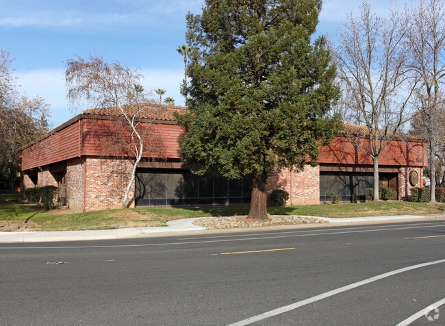
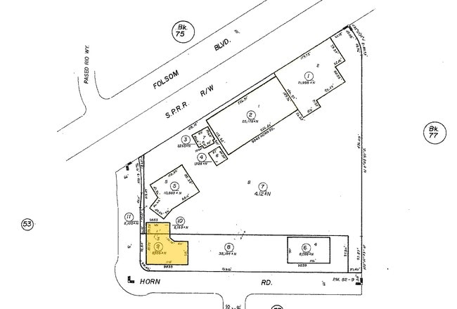
Property Record
9833 Horn Rd, Sacramento, CA 95827
Current Lease Availabilities
NEARBY LISTINGS FOR SALE OR LEASE
Property Detail
9833 Horn Rd
068-0590-009
Old Mills Winery Office Park
Officebuilding
PCL 3 OF BK 82 PARCEL MAPS PG 9 EXC NLY 33.28 FT ALSO EXCM/R CONTG 8,556 SQ FT M/L.
X
Sacramento
06067C0205H
California
2024
0.20 AC
2025
Highway 50 Corridor
009006
Sacramento
7,040 SF
Sacramento--Roseville--Arden-Arcade, CA
DEMOGRAPHICS near 9833 Horn Rd
1 Mile
3 Mile
5 Mile
2024 Total Population
15,525
113,054
254,647
2029 Population
15,553
113,770
256,183
Pop Growth 2024-2029
+ 0.18%
+ 0.63%
+ 0.60%
Average Age
38
40
40
2024 Total Households
5,485
42,753
100,678
HH Growth 2024-2029
+ 0.13%
+ 0.63%
+ 0.63%
Median Household Inc
$70,315
$83,616
$75,403
Avg Household Size
2.80
2.60
2.40
2024 Avg HH Vehicles
2.00
2.00
2.00
Median Home Value
$362,437
$447,399
$462,367
Median Year Built
1975
1973
1972
Nearby Places
Map Layers
Map Styles
 Street
 Aerial
- Restaurants
- Banks
- Shops
- Fitness
- Groceries
PUBLIC TRANSPORTATION
AIRPORT
Sacramento International
DRIVE
WALK
Distance
Sacramento International
30 min
22.4 mi
Nearby Properties
Address
Land Use
TOTAL SIZE
Lot Size
Zoning
Address
Land Use
TOTAL SIZE
Lot Size
Zoning
266,841 SF
47.29 AC
RD-5
Address
Land Use
TOTAL SIZE
Lot Size
Zoning
251,024 SF
5.19 AC
SPA (CVSPA
Address
Land Use
TOTAL SIZE
Lot Size
Zoning
223,046 SF
10.99 AC
RD 20
Address
Land Use
TOTAL SIZE
Lot Size
Zoning
109,805 SF
20.04 AC
OPMU
Address
Land Use
TOTAL SIZE
Lot Size
Zoning
181,573 SF
12.10 AC
SPA (MFSPA
Address
Land Use
TOTAL SIZE
Lot Size
Zoning
192,500 SF
11.78 AC
OPMU
Address
Land Use
TOTAL SIZE
Lot Size
Zoning
137,520 SF
10.37 AC
BP (PC)(PD
Address
Land Use
TOTAL SIZE
Lot Size
Zoning
387,136 SF
8.85 AC
RD-30
Address
Land Use
TOTAL SIZE
Lot Size
Zoning
168,846 SF
7.58 AC
RD-30 (PC)
Address
Land Use
TOTAL SIZE
Lot Size
Zoning
139,500 SF
5.21 AC
MP
Address
Land Use
TOTAL SIZE
Lot Size
Zoning
162,023 SF
8.96 AC
OIMU
Address
Land Use
TOTAL SIZE
Lot Size
Zoning
119,824 SF
7.64 AC
RD-30 (PC)
Address
Land Use
TOTAL SIZE
Lot Size
Zoning
0.21 AC
RD-5
Address
Land Use
TOTAL SIZE
Lot Size
Zoning
6.31 AC
RC (ZSPA)
Address
Land Use
TOTAL SIZE
Lot Size
Zoning
135,375 SF
7.40 AC
RD-30
Address
Land Use
TOTAL SIZE
Lot Size
Zoning
221,337 SF
12.19 AC
RD 25
Address
Land Use
TOTAL SIZE
Lot Size
Zoning
132,149 SF
8.29 AC
OPMU
Address
Land Use
TOTAL SIZE
Lot Size
Zoning
95,174 SF
5.29 AC
SPA (MFSPA
Address
Land Use
TOTAL SIZE
Lot Size
Zoning
198,131 SF
13.36 AC
BP
Address
Land Use
TOTAL SIZE
Lot Size
Zoning
156,032 SF
9.31 AC
OPMU
Address
Land Use
TOTAL SIZE
Lot Size
Zoning
218,216 SF
14.22 AC
OPMU
Address
Land Use
TOTAL SIZE
Lot Size
Zoning
169,618 SF
10.44 AC
RD-4
Address
Land Use
TOTAL SIZE
Lot Size
Zoning
198,413 SF
9.24 AC
RD 30
Address
Land Use
TOTAL SIZE
Lot Size
Zoning
135,197 SF
11.38 AC
SPA (CVSPA
Address
Land Use
TOTAL SIZE
Lot Size
Zoning
12.47 AC
RD 30
Address
Land Use
TOTAL SIZE
Lot Size
Zoning
457,088 SF
12.50 AC
RD 30
Address
Land Use
TOTAL SIZE
Lot Size
Zoning
98,767 SF
6.43 AC
BP (ZSPA)
Address
Land Use
TOTAL SIZE
Lot Size
Zoning
89,098 SF
4.93 AC
RD-40
Address
Land Use
TOTAL SIZE
Lot Size
Zoning
302,966 SF
15.94 AC
RD 30
Address
Land Use
TOTAL SIZE
Lot Size
Zoning
258,819 SF
13.47 AC
RD 30
The World's #1 Commercial Real Estate Marketplace
Connect with us
© 2025 CoStar Group
The information above has been obtained from sources believed reliable. While we do not doubt its accuracy we have not verified it and make no guarantee, warranty or representation about it. It is your responsibility to independently confirm its accuracy and completeness. Any projections, opinions, assumptions, or estimates used are for example only and do not represent the current or future performance of the property. The value of this transaction to you depends on tax and other factors which should be evaluated by your tax, financial, and legal advisors. You and your advisors should conduct a careful, independent investigation of the property to determine to your satisfaction the suitability of the property for your needs.