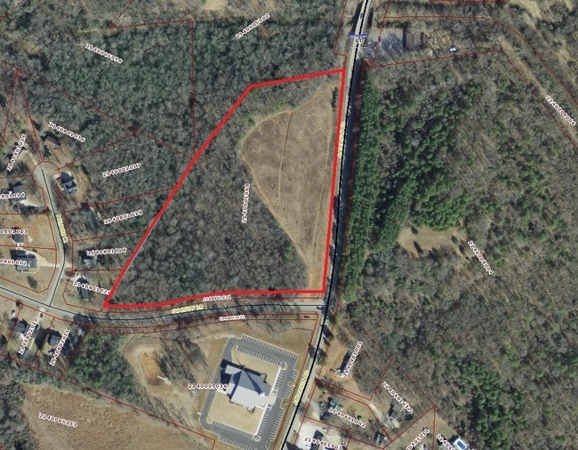
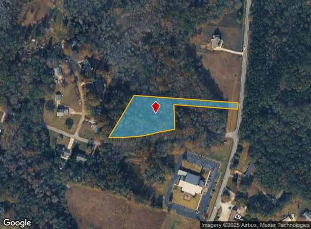
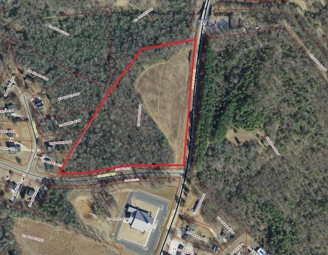
Property Record
9835 Anderson Rd, Easley, SC 29642
NEARBY LISTINGS FOR SALE OR LEASE
Property Detail
9835 Anderson Rd
Greenville-Anderson-Greer, SC
CP S 2820/5 F000 D000 LT 1 ANDERSON RD 2.42 AC
214-00-05-068
Anderson
Agriculturalland
South Carolina
AE
1
45007C0044E
2.42 AC
2023
Anderson County
2024
Greenville/Spartanburg
010904
DEMOGRAPHICS near 9835 Anderson Rd
1 Mile
3 Mile
5 Mile
2024 Total Population
1,575
16,616
49,966
2029 Population
1,676
17,741
53,552
Pop Growth 2024-2029
+ 6.41%
+ 6.77%
+ 7.18%
Average Age
39
39
40
2024 Total Households
555
6,086
18,507
HH Growth 2024-2029
+ 6.49%
+ 6.87%
+ 7.24%
Median Household Inc
$94,457
$80,634
$66,847
Avg Household Size
2.80
2.70
2.60
2024 Avg HH Vehicles
3.00
2.00
2.00
Median Home Value
$265,021
$250,224
$224,386
Median Year Built
1995
1994
1992
Nearby Places
Map Layers
Map Styles
 Street
 Aerial
- Restaurants
- Banks
- Shops
- Fitness
- Groceries
PUBLIC TRANSPORTATION
AIRPORT
Greenville Spartanburg International
DRIVE
WALK
Distance
Greenville Spartanburg International
34 min
22.4 mi
Freight Ports
North Charleston Terminal
DRIVE
WALK
Distance
North Charleston Terminal
237 min
208.8 mi
SALE & LEASE HISTORY
LISTING DATE
SALE/LEASE

Sep 24, 2016
For Sale
Oct 26, 2016
For Sale
Oct 10, 2017
For Sale
Aug 07, 2020
For Sale
Nearby Properties
Address
Land Use
TOTAL SIZE
Lot Size
Zoning
Address
Land Use
TOTAL SIZE
Lot Size
Zoning
285,475 SF
25.82 AC
Address
Land Use
TOTAL SIZE
Lot Size
Zoning
149,800 SF
35.99 AC
Address
Land Use
TOTAL SIZE
Lot Size
Zoning
683 SF
16.53 AC
Address
Land Use
TOTAL SIZE
Lot Size
Zoning
4,778 SF
10.45 AC
Address
Land Use
TOTAL SIZE
Lot Size
Zoning
150,809 SF
15.35 AC
Address
Land Use
TOTAL SIZE
Lot Size
Zoning
0.65 AC
PD
Address
Land Use
TOTAL SIZE
Lot Size
Zoning
71,754 SF
9.46 AC
Address
Land Use
TOTAL SIZE
Lot Size
Zoning
4,930 SF
11.46 AC
Address
Land Use
TOTAL SIZE
Lot Size
Zoning
70,058 SF
11.45 AC
Address
Land Use
TOTAL SIZE
Lot Size
Zoning
58,460 SF
1.43 AC
Address
Land Use
TOTAL SIZE
Lot Size
Zoning
10,059 SF
0.92 AC
Address
Land Use
TOTAL SIZE
Lot Size
Zoning
47,588 SF
2.27 AC
Address
Land Use
TOTAL SIZE
Lot Size
Zoning
7.39 AC
Address
Land Use
TOTAL SIZE
Lot Size
Zoning
37.40 AC
Address
Land Use
TOTAL SIZE
Lot Size
Zoning
14,684 SF
4.42 AC
Address
Land Use
TOTAL SIZE
Lot Size
Zoning
4,050 SF
7.45 AC
Address
Land Use
TOTAL SIZE
Lot Size
Zoning
7.06 AC
Address
Land Use
TOTAL SIZE
Lot Size
Zoning
21,696 SF
10.07 AC
Address
Land Use
TOTAL SIZE
Lot Size
Zoning
11,360 SF
1.52 AC
Address
Land Use
TOTAL SIZE
Lot Size
Zoning
4,509 SF
0.97 AC
Address
Land Use
TOTAL SIZE
Lot Size
Zoning
5,592 SF
11.77 AC
Address
Land Use
TOTAL SIZE
Lot Size
Zoning
4,825 SF
3.19 AC
Address
Land Use
TOTAL SIZE
Lot Size
Zoning
28,390 SF
3.97 AC
Address
Land Use
TOTAL SIZE
Lot Size
Zoning
38,152 SF
1.40 AC
Address
Land Use
TOTAL SIZE
Lot Size
Zoning
5,776 SF
1.61 AC
Address
Land Use
TOTAL SIZE
Lot Size
Zoning
20,271 SF
3.49 AC
Address
Land Use
TOTAL SIZE
Lot Size
Zoning
28,929 SF
1.70 AC
Address
Land Use
TOTAL SIZE
Lot Size
Zoning
21,840 SF
8.21 AC
The World's #1 Commercial Real Estate Marketplace
Connect with us
© 2026 CoStar Group
The information above has been obtained from sources believed reliable. While we do not doubt its accuracy we have not verified it and make no guarantee, warranty or representation about it. It is your responsibility to independently confirm its accuracy and completeness. Any projections, opinions, assumptions, or estimates used are for example only and do not represent the current or future performance of the property. The value of this transaction to you depends on tax and other factors which should be evaluated by your tax, financial, and legal advisors. You and your advisors should conduct a careful, independent investigation of the property to determine to your satisfaction the suitability of the property for your needs.