Property Record
9837 Old Roanoke Rd, Elliston, VA 24087

NEARBY LISTINGS FOR SALE OR LEASE
-
-
View all Elliston listings for sale on LoopNet.com
Property Detail
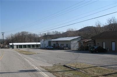
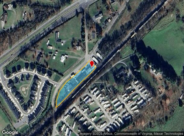
9837 Old Roanoke Rd
012024
R G MOSES & J W CARTER TR 4
Commercialnec
Montgomery
X
Virginia
51121C0177C
1.33 AC
2025
Blacksburg & Wytheville
2025
Other Market Areas
021300
Blacksburg-Christiansburg-Radford, VA
3,840 SF
DEMOGRAPHICS near 9837 Old Roanoke Rd
1 Mile
3 Mile
5 Mile
2024 Total Population
863
2,697
6,963
2029 Population
862
2,677
6,899
Pop Growth 2024-2029
(0.12%)
(0.74%)
(0.92%)
Average Age
39
43
44
2024 Total Households
353
1,013
2,604
HH Growth 2024-2029
(0.28%)
(0.99%)
(1.08%)
Median Household Inc
$37,521
$38,439
$54,295
Avg Household Size
2.40
2.40
2.40
2024 Avg HH Vehicles
2.00
2.00
2.00
Median Home Value
$128,161
$148,684
$191,679
Median Year Built
1971
1977
1978
Nearby Places
Map Layers
Map Styles
 Street
 Aerial
- Restaurants
- Banks
- Shops
- Fitness
- Groceries
PUBLIC TRANSPORTATION
AIRPORT
Roanoke/Blacksburg Regional (Woodrum Field)
DRIVE
WALK
Distance
Roanoke/Blacksburg Regional (Woodrum Field)
29 min
19.6 mi
Freight Ports
Virginia Port Authority - Richmond
DRIVE
WALK
Distance
Virginia Port Authority - Richmond
231 min
203.4 mi
Nearby Properties
Address
Land Use
TOTAL SIZE
Lot Size
Zoning
Address
Land Use
TOTAL SIZE
Lot Size
Zoning
265,000 SF
42.71 AC
AG3S
Address
Land Use
TOTAL SIZE
Lot Size
Zoning
375,302 SF
37.71 AC
PIN
Address
Land Use
TOTAL SIZE
Lot Size
Zoning
107,055 SF
34.45 AC
A1
Address
Land Use
TOTAL SIZE
Lot Size
Zoning
98,713 SF
0.02 AC
A1
Address
Land Use
TOTAL SIZE
Lot Size
Zoning
36,873 SF
29.63 AC
I2
Address
Land Use
TOTAL SIZE
Lot Size
Zoning
6,300 SF
617.74 AC
AG3
Address
Land Use
TOTAL SIZE
Lot Size
Zoning
20,163 SF
3.78 AC
GB
Address
Land Use
TOTAL SIZE
Lot Size
Zoning
16,480 SF
10.32 AC
M1
Address
Land Use
TOTAL SIZE
Lot Size
Zoning
32,620 SF
2.61 AC
M1
Address
Land Use
TOTAL SIZE
Lot Size
Zoning
12,297 SF
1.75 AC
M1
Address
Land Use
TOTAL SIZE
Lot Size
Zoning
5,933 SF
2.49 AC
C2
Address
Land Use
TOTAL SIZE
Lot Size
Zoning
5.95 AC
M1
Address
Land Use
TOTAL SIZE
Lot Size
Zoning
95.79 AC
A1
Address
Land Use
TOTAL SIZE
Lot Size
Zoning
1.28 AC
GB
Address
Land Use
TOTAL SIZE
Lot Size
Zoning
5,777 SF
188.10 AC
A1
Address
Land Use
TOTAL SIZE
Lot Size
Zoning
9.15 AC
A1
Address
Land Use
TOTAL SIZE
Lot Size
Zoning
16.70 AC
Address
Land Use
TOTAL SIZE
Lot Size
Zoning
Address
Land Use
TOTAL SIZE
Lot Size
Zoning
1,500 SF
9.84 AC
M1
Address
Land Use
TOTAL SIZE
Lot Size
Zoning
25,000 SF
3.24 AC
M1
Address
Land Use
TOTAL SIZE
Lot Size
Zoning
10,545 SF
2.41 AC
A1
Address
Land Use
TOTAL SIZE
Lot Size
Zoning
4.80 AC
A1
Address
Land Use
TOTAL SIZE
Lot Size
Zoning
16,422 SF
45.48 AC
AR
Address
Land Use
TOTAL SIZE
Lot Size
Zoning
2,240 SF
70.50 AC
AG3S
Address
Land Use
TOTAL SIZE
Lot Size
Zoning
110.04 AC
AG1
Address
Land Use
TOTAL SIZE
Lot Size
Zoning
2,005 SF
96 AC
A1
Address
Land Use
TOTAL SIZE
Lot Size
Zoning
Address
Land Use
TOTAL SIZE
Lot Size
Zoning
2.89 AC
GB
Address
Land Use
TOTAL SIZE
Lot Size
Zoning
5,272 SF
23.67 AC
A1
The World's #1 Commercial Real Estate Marketplace
Connect with us
© 2025 CoStar Group
The information above has been obtained from sources believed reliable. While we do not doubt its accuracy we have not verified it and make no guarantee, warranty or representation about it. It is your responsibility to independently confirm its accuracy and completeness. Any projections, opinions, assumptions, or estimates used are for example only and do not represent the current or future performance of the property. The value of this transaction to you depends on tax and other factors which should be evaluated by your tax, financial, and legal advisors. You and your advisors should conduct a careful, independent investigation of the property to determine to your satisfaction the suitability of the property for your needs.