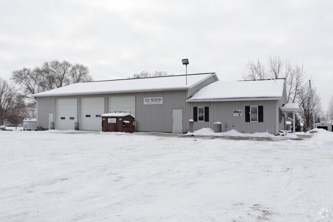
Property Record
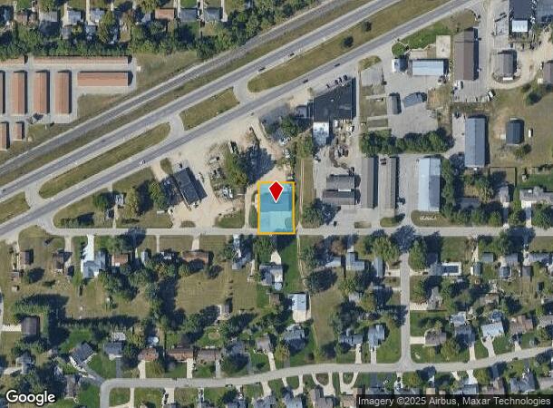
985 Rosewood St, Jenison, MI 49428

NEARBY LISTINGS FOR SALE OR LEASE
Property Detail
985 Rosewood St
70-14-23-250-019
PART NE 1/4 OF NE 1/4 COM SW COR, TH E TO PT 12146 FT W OF E SEC LINE, TH N 158 FT, W TO E 1/8 LINE, TH S 158 FT TO BEG SEC
Autorepair
Ottawa
X
Michigan
26081C0393D
0.32 AC
2024
E Ottawa Cnty/Hudsonville
2025
West Michigan
021606
Grand Rapids-Wyoming, MI
4,300 SF
DEMOGRAPHICS near 985 Rosewood St
1 Mile
3 Mile
5 Mile
2024 Total Population
7,140
50,884
116,615
2029 Population
7,514
52,713
120,500
Pop Growth 2024-2029
+ 5.24%
+ 3.59%
+ 3.33%
Average Age
42
40
38
2024 Total Households
2,888
19,253
43,090
HH Growth 2024-2029
+ 5.44%
+ 3.73%
+ 3.31%
Median Household Inc
$65,826
$78,102
$80,868
Avg Household Size
2.40
2.60
2.60
2024 Avg HH Vehicles
2.00
2.00
2.00
Median Home Value
$215,927
$253,180
$253,928
Median Year Built
1973
1978
1983
Nearby Places
Map Layers
Map Styles
 Street
 Aerial
- Restaurants
- Banks
- Shops
- Fitness
- Groceries
PUBLIC TRANSPORTATION
COMMUTER RAIL
Grand Rapids Vernon J. Ehlers Station (Pere Marquette - Amtrak)
DRIVE
WALK
Distance
Grand Rapids Vernon J. Ehlers Station (Pere Marquette - Amtrak)
13 min
9.0 mi
AIRPORT
Gerald R Ford International
DRIVE
WALK
Distance
Gerald R Ford International
31 min
17.2 mi
Freight Ports
Port Milwaukee
DRIVE
WALK
Distance
Port Milwaukee
297 min
253.4 mi
Nearby Properties
Address
Land Use
TOTAL SIZE
Lot Size
Zoning
Address
Land Use
TOTAL SIZE
Lot Size
Zoning
79.40 AC
C-4
Address
Land Use
TOTAL SIZE
Lot Size
Zoning
12.64 AC
PUD
Address
Land Use
TOTAL SIZE
Lot Size
Zoning
268,440 SF
28.11 AC
HDR
Address
Land Use
TOTAL SIZE
Lot Size
Zoning
225,992 SF
14.40 AC
Address
Land Use
TOTAL SIZE
Lot Size
Zoning
20.61 AC
HDR
Address
Land Use
TOTAL SIZE
Lot Size
Zoning
230,864 SF
59.58 AC
PUD2
Address
Land Use
TOTAL SIZE
Lot Size
Zoning
269,021 SF
22.89 AC
HDR
Address
Land Use
TOTAL SIZE
Lot Size
Zoning
173,288 SF
4.17 AC
PUD
Address
Land Use
TOTAL SIZE
Lot Size
Zoning
211,138 SF
30.58 AC
C-5
Address
Land Use
TOTAL SIZE
Lot Size
Zoning
222,785 SF
26.69 AC
CS
Address
Land Use
TOTAL SIZE
Lot Size
Zoning
124,950 SF
18.30 AC
MHR
Address
Land Use
TOTAL SIZE
Lot Size
Zoning
14.69 AC
R3-B
Address
Land Use
TOTAL SIZE
Lot Size
Zoning
89,648 SF
3.17 AC
OS-2
Address
Land Use
TOTAL SIZE
Lot Size
Zoning
9.65 AC
R3-B
Address
Land Use
TOTAL SIZE
Lot Size
Zoning
139,774 SF
10.67 AC
HDR-B
Address
Land Use
TOTAL SIZE
Lot Size
Zoning
9 AC
R3-A
Address
Land Use
TOTAL SIZE
Lot Size
Zoning
60,523 SF
6.48 AC
C-1
Address
Land Use
TOTAL SIZE
Lot Size
Zoning
82,554 SF
5.56 AC
HDR
Address
Land Use
TOTAL SIZE
Lot Size
Zoning
136,766 SF
18.52 AC
B3
Address
Land Use
TOTAL SIZE
Lot Size
Zoning
164,700 SF
19.18 AC
C-5
Address
Land Use
TOTAL SIZE
Lot Size
Zoning
60,980 SF
2.51 AC
PUD
Address
Land Use
TOTAL SIZE
Lot Size
Zoning
135,752 SF
13.86 AC
C-5
Address
Land Use
TOTAL SIZE
Lot Size
Zoning
62,080 SF
2.54 AC
PUD
Address
Land Use
TOTAL SIZE
Lot Size
Zoning
6.77 AC
R3-B
Address
Land Use
TOTAL SIZE
Lot Size
Zoning
71,102 SF
8.65 AC
MHR
Address
Land Use
TOTAL SIZE
Lot Size
Zoning
45,636 SF
14.11 AC
C-5
Address
Land Use
TOTAL SIZE
Lot Size
Zoning
120,236 SF
13.33 AC
ER
Address
Land Use
TOTAL SIZE
Lot Size
Zoning
106,193 SF
10.68 AC
CS
Address
Land Use
TOTAL SIZE
Lot Size
Zoning
50,554 SF
3.98 AC
PUD2
Address
Land Use
TOTAL SIZE
Lot Size
Zoning
54,987 SF
16.50 AC
I-2
The World's #1 Commercial Real Estate Marketplace
Connect with us
© 2025 CoStar Group
The information above has been obtained from sources believed reliable. While we do not doubt its accuracy we have not verified it and make no guarantee, warranty or representation about it. It is your responsibility to independently confirm its accuracy and completeness. Any projections, opinions, assumptions, or estimates used are for example only and do not represent the current or future performance of the property. The value of this transaction to you depends on tax and other factors which should be evaluated by your tax, financial, and legal advisors. You and your advisors should conduct a careful, independent investigation of the property to determine to your satisfaction the suitability of the property for your needs.