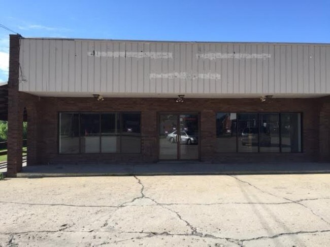
Property Record
985 W Pershing Rd, Decatur, IL 62526

Property Detail
985 W Pershing Rd
04-12-03-101-009
N280 OF E354.84 W977.60 ~(EXC ROW) NW1/4 NW1/4
Regionalshoppingcenterormallwithanchorstore
Macon
MUNICIPAL
Illinois
B and X Area of moderate flood hazard, usually the area between the limits of the 100-year and 500-year floods.
2.28 AC
2024
Springfield/Decatur
2024
Other Market Areas
002001
Decatur, IL
NEARBY LISTINGS FOR SALE OR LEASE
DEMOGRAPHICS near 985 W Pershing Rd
1 mile
3 mile
5 mile
2025 Total Population
5,503
45,315
69,255
2030 Population
5,370
44,995
68,391
Pop Growth 2025-2030
(2.42%)
(0.71%)
(1.25%)
Average Age
46
40
40
2025 Total Households
2,582
19,524
30,078
HH Growth 2025-2030
(2.56%)
(0.76%)
(1.33%)
Median Household Inc
$44,238
$42,422
$46,965
Avg Household Size
1.90
2.10
2.10
2025 Avg HH Vehicles
1.00
1.00
2.00
Median Home Value
$105,410
$86,202
$90,094
Median Year Built
1967
1960
1960
Nearby Places
Map Layers
Map Styles
 Street
 Aerial
Layers
 Traffic
 Biking
Places
Listings with unknown addresses are not visible on the map
- Restaurants
- Banks
- Shops
- Fitness
- Groceries
SALE & LEASE HISTORY
LISTING DATE
SALE/LEASE

Mar 30, 2018
For Lease
Mar 30, 2017
For Lease
Mar 09, 2025
For Sale
Jun 09, 2020
For Sale
Jul 30, 2019
For Lease
Jan 26, 2023
For Lease
Jan 26, 2021
For Lease
Aug 31, 2018
For Lease
Apr 04, 2017
For Sale
Nearby Properties
Address
Land Use
TOTAL SIZE
Lot Size
Zoning
Address
Land Use
TOTAL SIZE
Lot Size
Zoning
12.21 AC
MUNICIPAL
Address
Land Use
TOTAL SIZE
Lot Size
Zoning
1.03 AC
MUNICIPAL
Address
Land Use
TOTAL SIZE
Lot Size
Zoning
207,420 SF
12.41 AC
MUNICIPAL
Address
Land Use
TOTAL SIZE
Lot Size
Zoning
1.40 AC
MUNICIPAL
Address
Land Use
TOTAL SIZE
Lot Size
Zoning
6.60 AC
MUNICIPAL
Address
Land Use
TOTAL SIZE
Lot Size
Zoning
1,604 SF
12.80 AC
MUNICIPAL
Address
Land Use
TOTAL SIZE
Lot Size
Zoning
3.88 AC
MUNICIPAL
Address
Land Use
TOTAL SIZE
Lot Size
Zoning
13.92 AC
MUNICIPAL
Address
Land Use
TOTAL SIZE
Lot Size
Zoning
12.24 AC
MUNICIPAL
Address
Land Use
TOTAL SIZE
Lot Size
Zoning
6.68 AC
MUNICIPAL
Address
Land Use
TOTAL SIZE
Lot Size
Zoning
23.56 AC
MUNICIPAL
Address
Land Use
TOTAL SIZE
Lot Size
Zoning
18.50 AC
MUNICIPAL
Address
Land Use
TOTAL SIZE
Lot Size
Zoning
6.89 AC
MUNICIPAL
Address
Land Use
TOTAL SIZE
Lot Size
Zoning
19.95 AC
MUNICIPAL
Address
Land Use
TOTAL SIZE
Lot Size
Zoning
7.82 AC
MUNICIPAL
Address
Land Use
TOTAL SIZE
Lot Size
Zoning
3.35 AC
MUNICIPAL
Address
Land Use
TOTAL SIZE
Lot Size
Zoning
3.55 AC
MUNICIPAL
Address
Land Use
TOTAL SIZE
Lot Size
Zoning
14.66 AC
MUNICIPAL
Address
Land Use
TOTAL SIZE
Lot Size
Zoning
7.03 AC
MUNICIPAL
Address
Land Use
TOTAL SIZE
Lot Size
Zoning
1.10 AC
MUNICIPAL
Address
Land Use
TOTAL SIZE
Lot Size
Zoning
78.13 AC
MUNICIPAL
Address
Land Use
TOTAL SIZE
Lot Size
Zoning
4.82 AC
MUNICIPAL
Address
Land Use
TOTAL SIZE
Lot Size
Zoning
6.35 AC
MUNICIPAL
Address
Land Use
TOTAL SIZE
Lot Size
Zoning
3.93 AC
MUNICIPAL
Address
Land Use
TOTAL SIZE
Lot Size
Zoning
4.30 AC
MUNICIPAL
Address
Land Use
TOTAL SIZE
Lot Size
Zoning
9.53 AC
MUNICIPAL
Address
Land Use
TOTAL SIZE
Lot Size
Zoning
3.50 AC
MUNICIPAL
Address
Land Use
TOTAL SIZE
Lot Size
Zoning
14.73 AC
MUNICIPAL
Address
Land Use
TOTAL SIZE
Lot Size
Zoning
0.97 AC
MUNICIPAL
The World's #1 Commercial Real Estate Marketplace
Connect with us
© 2026 CoStar Group
The information above has been obtained from sources believed reliable. While we do not doubt its accuracy we have not verified it and make no guarantee, warranty or representation about it. It is your responsibility to independently confirm its accuracy and completeness. Any projections, opinions, assumptions, or estimates used are for example only and do not represent the current or future performance of the property. The value of this transaction to you depends on tax and other factors which should be evaluated by your tax, financial, and legal advisors. You and your advisors should conduct a careful, independent investigation of the property to determine to your satisfaction the suitability of the property for your needs.