Property Record
9850 La Branch Dr, Corpus Christi, TX 78410


NEARBY LISTINGS FOR SALE OR LEASE
-
-
View all Corpus Christi listings for sale on LoopNet.com
Property Detail
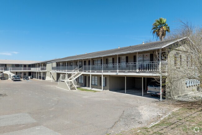
9850 La Branch Dr
Corpus Christi, TX
Westwood Shopping Center
200060394
Nueces
Duplex
Texas
X
2.16 AC
48355C0285G
Northwest Corpus Christi
20,074 SF
Corpus Christi
DEMOGRAPHICS near 9850 La Branch Dr
1 Mile
3 Mile
5 Mile
2024 Total Population
5,618
21,116
27,233
2029 Population
5,565
20,934
27,027
Pop Growth 2024-2029
(0.94%)
(0.86%)
(0.76%)
Average Age
35
36
37
2024 Total Households
1,942
7,498
9,611
HH Growth 2024-2029
(1.08%)
(1.09%)
(1.00%)
Median Household Inc
$83,078
$70,521
$70,989
Avg Household Size
2.80
2.70
2.80
2024 Avg HH Vehicles
2.00
2.00
2.00
Median Home Value
$180,664
$166,756
$163,826
Median Year Built
2000
1985
1985
Nearby Places
Map Layers
Map Styles
 Street
 Aerial
- Restaurants
- Banks
- Shops
- Fitness
- Groceries
PUBLIC TRANSPORTATION
AIRPORT
Corpus Christi International
DRIVE
WALK
Distance
Corpus Christi International
18 min
11.2 mi
Freight Ports
Port of Corpus Christi
DRIVE
WALK
Distance
Port of Corpus Christi
16 min
11.9 mi
SALE & LEASE HISTORY
LISTING DATE
SALE/LEASE

Apr 25, 2017
For Sale
Apr 25, 2017
For Sale
Nearby Properties
Address
Land Use
TOTAL SIZE
Lot Size
Zoning
Address
Land Use
TOTAL SIZE
Lot Size
Zoning
243,200 SF
59.43 AC
R1B
Address
Land Use
TOTAL SIZE
Lot Size
Zoning
126,708 SF
18.17 AC
R1B
Address
Land Use
TOTAL SIZE
Lot Size
Zoning
191,500 SF
14.33 AC
R1B
Address
Land Use
TOTAL SIZE
Lot Size
Zoning
368.71 AC
OCL
Address
Land Use
TOTAL SIZE
Lot Size
Zoning
7,450 SF
132 AC
R1B
Address
Land Use
TOTAL SIZE
Lot Size
Zoning
115,182 SF
12.34 AC
R1B
Address
Land Use
TOTAL SIZE
Lot Size
Zoning
234.07 AC
OCL
Address
Land Use
TOTAL SIZE
Lot Size
Zoning
141,800 SF
6 AC
Address
Land Use
TOTAL SIZE
Lot Size
Zoning
276.16 AC
R1B
Address
Land Use
TOTAL SIZE
Lot Size
Zoning
151,918 SF
10 AC
I-3
Address
Land Use
TOTAL SIZE
Lot Size
Zoning
69,436 SF
10.82 AC
R1B
Address
Land Use
TOTAL SIZE
Lot Size
Zoning
56,345 SF
2.47 AC
Address
Land Use
TOTAL SIZE
Lot Size
Zoning
1,750 SF
4.67 AC
R-1B
Address
Land Use
TOTAL SIZE
Lot Size
Zoning
167.06 AC
Address
Land Use
TOTAL SIZE
Lot Size
Zoning
66,052 SF
23.95 AC
I2SP08
Address
Land Use
TOTAL SIZE
Lot Size
Zoning
7,400 SF
43.16 AC
OCL
Address
Land Use
TOTAL SIZE
Lot Size
Zoning
36.26 AC
OCL
Address
Land Use
TOTAL SIZE
Lot Size
Zoning
333.74 AC
OCL
Address
Land Use
TOTAL SIZE
Lot Size
Zoning
81.50 AC
OCL
Address
Land Use
TOTAL SIZE
Lot Size
Zoning
14,765 SF
80 AC
R1B
Address
Land Use
TOTAL SIZE
Lot Size
Zoning
297.80 AC
Address
Land Use
TOTAL SIZE
Lot Size
Zoning
81,619 SF
9 AC
B4
Address
Land Use
TOTAL SIZE
Lot Size
Zoning
65,982 SF
9.13 AC
I-Z
Address
Land Use
TOTAL SIZE
Lot Size
Zoning
39,046 SF
4.24 AC
R1B
Address
Land Use
TOTAL SIZE
Lot Size
Zoning
36,288 SF
1.63 AC
B-4
Address
Land Use
TOTAL SIZE
Lot Size
Zoning
38,274 SF
10.63 AC
FR
Address
Land Use
TOTAL SIZE
Lot Size
Zoning
57,426 SF
6.88 AC
B-4
Address
Land Use
TOTAL SIZE
Lot Size
Zoning
17,906 SF
10.36 AC
B-4
Address
Land Use
TOTAL SIZE
Lot Size
Zoning
33,746 SF
0.53 AC
B-4
Address
Land Use
TOTAL SIZE
Lot Size
Zoning
49,884 SF
10.09 AC
FR
The World's #1 Commercial Real Estate Marketplace
Connect with us
© 2025 CoStar Group
The information above has been obtained from sources believed reliable. While we do not doubt its accuracy we have not verified it and make no guarantee, warranty or representation about it. It is your responsibility to independently confirm its accuracy and completeness. Any projections, opinions, assumptions, or estimates used are for example only and do not represent the current or future performance of the property. The value of this transaction to you depends on tax and other factors which should be evaluated by your tax, financial, and legal advisors. You and your advisors should conduct a careful, independent investigation of the property to determine to your satisfaction the suitability of the property for your needs.