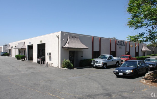
Property Record
9851 8Th St, Rancho Cucamonga, CA 91730

Property Detail
9851 8Th St
Riverside-San Bernardino-Ontario, CA
CUCAMONGA FRUIT LANDS PTN LOT 4 SEC 14 TP 1S R 7W LYING E OF LUCAS SUB AND S OF S LI EIGHTH ST AND SWLY OF SWLY LI LAND CONVEYED TO A T AND S F RR CO BY DEED RECORDED IN BOOK 6805 PG 985 OFFICIAL RECORDS EX STS 4-29-81 #81-093685
0209-193-09
San Bernardino
Lightindustrial
California
B and X Area of moderate flood hazard, usually the area between the limits of the 100-year and 500-year floods.
4
2025
5.83 AC
2025
Airport Area
002111
Inland Empire (California)
111,256 SF
NEARBY LISTINGS FOR SALE OR LEASE
DEMOGRAPHICS near 9851 8Th St
1 mile
3 mile
5 mile
2025 Total Population
14,137
142,436
335,487
2030 Population
14,204
143,697
337,609
Pop Growth 2025-2030
+ 0.47%
+ 0.89%
+ 0.63%
Average Age
38
38
38
2025 Total Households
4,770
48,170
108,543
HH Growth 2025-2030
+ 0.50%
+ 0.97%
+ 0.70%
Median Household Inc
$84,114
$89,981
$99,003
Avg Household Size
2.90
2.90
3.00
2025 Avg HH Vehicles
2.00
2.00
2.00
Median Home Value
$645,446
$665,658
$709,110
Median Year Built
1984
1984
1981
Nearby Places
Map Layers
Map Styles
 Street
 Aerial
Layers
 Traffic
 Biking
Places
Listings with unknown addresses are not visible on the map
- Restaurants
- Banks
- Shops
- Fitness
- Groceries
PUBLIC TRANSPORTATION
COMMUTER RAIL
Rancho Cucamonga (San Bernardino Line - Southern California Regional Rail Authority (Metrolink))
Drive
Walk
Distance
Rancho Cucamonga (San Bernardino Line - Southern California Regional Rail Authority (Metrolink))
7 min
3.4 mi
Upland (San Bernardino Line - Southern California Regional Rail Authority (Metrolink))
Drive
Walk
Distance
Upland (San Bernardino Line - Southern California Regional Rail Authority (Metrolink))
7 min
3.6 mi
AIRPORT
Ontario International
Drive
Walk
Distance
Ontario International
7 min
3.0 mi
John Wayne/Orange County
Drive
Walk
Distance
John Wayne/Orange County
56 min
44.8 mi
Nearby Properties
Address
Land Use
TOTAL SIZE
Lot Size
Zoning
Address
Land Use
TOTAL SIZE
Lot Size
Zoning
1,459,702 SF
96.41 AC
Address
Land Use
TOTAL SIZE
Lot Size
Zoning
376,610 SF
25.22 AC
Address
Land Use
TOTAL SIZE
Lot Size
Zoning
244,370 SF
59.72 AC
Address
Land Use
TOTAL SIZE
Lot Size
Zoning
707,551 SF
20.36 AC
Address
Land Use
TOTAL SIZE
Lot Size
Zoning
539,128 SF
10.24 AC
Address
Land Use
TOTAL SIZE
Lot Size
Zoning
293,860 SF
16.10 AC
Address
Land Use
TOTAL SIZE
Lot Size
Zoning
545,161 SF
11.10 AC
Address
Land Use
TOTAL SIZE
Lot Size
Zoning
453,960 SF
18.54 AC
Address
Land Use
TOTAL SIZE
Lot Size
Zoning
591,495 SF
18.29 AC
Address
Land Use
TOTAL SIZE
Lot Size
Zoning
1,052,840 SF
41.85 AC
Address
Land Use
TOTAL SIZE
Lot Size
Zoning
531,988 SF
9.83 AC
Address
Land Use
TOTAL SIZE
Lot Size
Zoning
286,732 SF
9.58 AC
Address
Land Use
TOTAL SIZE
Lot Size
Zoning
261,357 SF
10.03 AC
Address
Land Use
TOTAL SIZE
Lot Size
Zoning
440,209 SF
10.34 AC
Address
Land Use
TOTAL SIZE
Lot Size
Zoning
830,300 SF
39.99 AC
Address
Land Use
TOTAL SIZE
Lot Size
Zoning
190,724 SF
10.69 AC
Address
Land Use
TOTAL SIZE
Lot Size
Zoning
387,965 SF
10.92 AC
Address
Land Use
TOTAL SIZE
Lot Size
Zoning
468,682 SF
19.40 AC
Address
Land Use
TOTAL SIZE
Lot Size
Zoning
174,092 SF
4.42 AC
Address
Land Use
TOTAL SIZE
Lot Size
Zoning
358,375 SF
9.30 AC
Address
Land Use
TOTAL SIZE
Lot Size
Zoning
183,039 SF
8.30 AC
Address
Land Use
TOTAL SIZE
Lot Size
Zoning
246,012 SF
5.97 AC
Address
Land Use
TOTAL SIZE
Lot Size
Zoning
314,559 SF
9.34 AC
Address
Land Use
TOTAL SIZE
Lot Size
Zoning
573,220 SF
32.33 AC
Address
Land Use
TOTAL SIZE
Lot Size
Zoning
780,648 SF
13.59 AC
Address
Land Use
TOTAL SIZE
Lot Size
Zoning
329,030 SF
15.98 AC
Address
Land Use
TOTAL SIZE
Lot Size
Zoning
273,249 SF
11.07 AC
Address
Land Use
TOTAL SIZE
Lot Size
Zoning
303,915 SF
11.13 AC
Address
Land Use
TOTAL SIZE
Lot Size
Zoning
553,882 SF
24.59 AC
Address
Land Use
TOTAL SIZE
Lot Size
Zoning
612,104 SF
28.37 AC
The World's #1 Commercial Real Estate Marketplace
Connect with us
© 2026 CoStar Group
The information above has been obtained from sources believed reliable. While we do not doubt its accuracy we have not verified it and make no guarantee, warranty or representation about it. It is your responsibility to independently confirm its accuracy and completeness. Any projections, opinions, assumptions, or estimates used are for example only and do not represent the current or future performance of the property. The value of this transaction to you depends on tax and other factors which should be evaluated by your tax, financial, and legal advisors. You and your advisors should conduct a careful, independent investigation of the property to determine to your satisfaction the suitability of the property for your needs.