Property Record
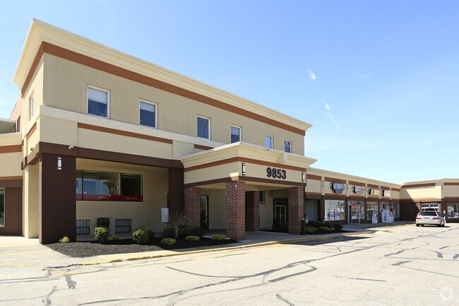
9853 Johnnycake Ridge Rd, Mentor, OH 44060


NEARBY LISTINGS FOR SALE OR LEASE
Property Detail
9853 Johnnycake Ridge Rd
Cleveland-Elyria, OH
Heatherstone Village 02 01 Ph 01
10-A-028-D-00-001
LOT 26 TRACT 4
Regionalshoppingcenterormallwithanchorstore
Lake
X
Ohio
39085C0116F
26
0
4.01 AC
2024
Northeast
205001
Cleveland
68,124 SF
DEMOGRAPHICS near 9853 Johnnycake Ridge Rd
1 Mile
3 Mile
5 Mile
2024 Total Population
6,511
38,560
94,563
2029 Population
6,429
38,415
94,307
Pop Growth 2024-2029
(1.26%)
(0.38%)
(0.27%)
Average Age
46
44
43
2024 Total Households
2,774
15,874
38,898
HH Growth 2024-2029
(1.41%)
(0.45%)
(0.31%)
Median Household Inc
$101,803
$95,769
$84,442
Avg Household Size
2.30
2.40
2.40
2024 Avg HH Vehicles
2.00
2.00
2.00
Median Home Value
$232,520
$235,874
$214,315
Median Year Built
1979
1980
1976
Nearby Places
Map Layers
Map Styles
 Street
 Aerial
- Restaurants
- Banks
- Shops
- Fitness
- Groceries
SALE & LEASE HISTORY
LISTING DATE
SALE/LEASE

Sep 25, 2016
For Lease
Nov 29, 2016
For Lease
Mar 06, 2018
For Lease
Aug 23, 2017
For Lease
Apr 30, 2019
For Lease
Nearby Properties
Address
Land Use
TOTAL SIZE
Lot Size
Zoning
Address
Land Use
TOTAL SIZE
Lot Size
Zoning
441,820 SF
45.04 AC
Address
Land Use
TOTAL SIZE
Lot Size
Zoning
15.89 AC
Address
Land Use
TOTAL SIZE
Lot Size
Zoning
241,548 SF
22.28 AC
Address
Land Use
TOTAL SIZE
Lot Size
Zoning
89,317 SF
7.64 AC
Address
Land Use
TOTAL SIZE
Lot Size
Zoning
580,720 SF
22.25 AC
R-4
Address
Land Use
TOTAL SIZE
Lot Size
Zoning
16,955 SF
69.10 AC
B3
Address
Land Use
TOTAL SIZE
Lot Size
Zoning
141,980 SF
31.16 AC
R-5
Address
Land Use
TOTAL SIZE
Lot Size
Zoning
13.60 AC
Address
Land Use
TOTAL SIZE
Lot Size
Zoning
158,554 SF
23.10 AC
B-2
Address
Land Use
TOTAL SIZE
Lot Size
Zoning
32,209 SF
304.90 AC
R-1
Address
Land Use
TOTAL SIZE
Lot Size
Zoning
111,506 SF
9.84 AC
Address
Land Use
TOTAL SIZE
Lot Size
Zoning
198,502 SF
39.56 AC
Address
Land Use
TOTAL SIZE
Lot Size
Zoning
Address
Land Use
TOTAL SIZE
Lot Size
Zoning
55,441 SF
8.82 AC
R-4
Address
Land Use
TOTAL SIZE
Lot Size
Zoning
101,472 SF
9.07 AC
B-2
Address
Land Use
TOTAL SIZE
Lot Size
Zoning
211,307 SF
11.29 AC
M-1
Address
Land Use
TOTAL SIZE
Lot Size
Zoning
59,448 SF
Address
Land Use
TOTAL SIZE
Lot Size
Zoning
188,875 SF
25.67 AC
M-2
Address
Land Use
TOTAL SIZE
Lot Size
Zoning
138,290 SF
1.73 AC
M-1
Address
Land Use
TOTAL SIZE
Lot Size
Zoning
61,567 SF
25.17 AC
Address
Land Use
TOTAL SIZE
Lot Size
Zoning
187,661 SF
22.19 AC
R-4
Address
Land Use
TOTAL SIZE
Lot Size
Zoning
122,256 SF
11.73 AC
B-2
Address
Land Use
TOTAL SIZE
Lot Size
Zoning
12.50 AC
Address
Land Use
TOTAL SIZE
Lot Size
Zoning
117,081 SF
17.65 AC
R-1
Address
Land Use
TOTAL SIZE
Lot Size
Zoning
Address
Land Use
TOTAL SIZE
Lot Size
Zoning
60,153 SF
25.28 AC
Address
Land Use
TOTAL SIZE
Lot Size
Zoning
Address
Land Use
TOTAL SIZE
Lot Size
Zoning
91,080 SF
10.72 AC
B-2
Address
Land Use
TOTAL SIZE
Lot Size
Zoning
42,089 SF
7.33 AC
Address
Land Use
TOTAL SIZE
Lot Size
Zoning
13,200 SF
2.46 AC
The World's #1 Commercial Real Estate Marketplace
Connect with us
© 2025 CoStar Group
The information above has been obtained from sources believed reliable. While we do not doubt its accuracy we have not verified it and make no guarantee, warranty or representation about it. It is your responsibility to independently confirm its accuracy and completeness. Any projections, opinions, assumptions, or estimates used are for example only and do not represent the current or future performance of the property. The value of this transaction to you depends on tax and other factors which should be evaluated by your tax, financial, and legal advisors. You and your advisors should conduct a careful, independent investigation of the property to determine to your satisfaction the suitability of the property for your needs.