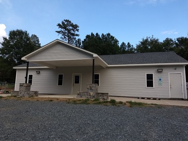
Property Record
9870 Highway 601, Midland, NC 28107


Save to a Folder
{{folder.Name}}
{{folder.ListingIds.length}} Properties
{{folder.ListingIds.length}} Property
Create a New Folder
Property Detail
9870 Highway 601
5556-00-8684-0000
BOTH SIDES US HWY 601 S
Daycare
Cabarrus
AG
North Carolina
B and X Area of moderate flood hazard, usually the area between the limits of the 100-year and 500-year floods.
4.05 AC
2025
Cabarrus County
2025
Charlotte
041604
Charlotte-Concord-Gastonia, NC-SC
3,716 SF
NEARBY LISTINGS FOR SALE OR LEASE
-
-
View all Midland listings for sale on LoopNet.com
DEMOGRAPHICS near 9870 Highway 601
1 mile
3 mile
5 mile
2025 Total Population
501
5,584
21,298
2030 Population
537
5,977
22,892
Pop Growth 2025-2030
+ 7.19%
+ 7.04%
+ 7.48%
Average Age
42
41
40
2025 Total Households
179
2,037
7,898
HH Growth 2025-2030
+ 7.26%
+ 7.17%
+ 7.63%
Median Household Inc
$103,977
$99,861
$90,282
Avg Household Size
2.80
2.70
2.70
2025 Avg HH Vehicles
2.00
2.00
2.00
Median Home Value
$431,818
$417,921
$376,386
Median Year Built
1996
1999
1998
Nearby Places
Map Layers
Map Styles
 Street
 Aerial
Layers
 Traffic
 Biking
Places
Listings with unknown addresses are not visible on the map
- Restaurants
- Banks
- Shops
- Fitness
- Groceries
PUBLIC TRANSPORTATION
AIRPORT
Concord-Padgett Regional
Drive
Walk
Distance
Concord-Padgett Regional
31 min
21.1 mi
Charlotte/Douglas International
Drive
Walk
Distance
Charlotte/Douglas International
50 min
31.5 mi
SALE & LEASE HISTORY
LISTING DATE
SALE/LEASE

Mar 24, 2022
For Sale
Jan 09, 2020
For Sale
Nearby Properties
Address
Land Use
TOTAL SIZE
Lot Size
Zoning
Address
Land Use
TOTAL SIZE
Lot Size
Zoning
9,930 SF
601.95 AC
AO
Address
Land Use
TOTAL SIZE
Lot Size
Zoning
452.39 AC
CR
Address
Land Use
TOTAL SIZE
Lot Size
Zoning
27,500 SF
13.57 AC
C 24/27
Address
Land Use
TOTAL SIZE
Lot Size
Zoning
286.37 AC
AO
Address
Land Use
TOTAL SIZE
Lot Size
Zoning
8,094 SF
74.20 AC
IND
Address
Land Use
TOTAL SIZE
Lot Size
Zoning
33,510 SF
2.60 AC
C 24/27
Address
Land Use
TOTAL SIZE
Lot Size
Zoning
51,686 SF
30.01 AC
IND
Address
Land Use
TOTAL SIZE
Lot Size
Zoning
22,807 SF
4.28 AC
C 24/27
Address
Land Use
TOTAL SIZE
Lot Size
Zoning
220.75 AC
CR
Address
Land Use
TOTAL SIZE
Lot Size
Zoning
6,510 SF
17.57 AC
C 24/27
Address
Land Use
TOTAL SIZE
Lot Size
Zoning
16,439 SF
4.52 AC
C 601
Address
Land Use
TOTAL SIZE
Lot Size
Zoning
167.89 AC
CR
Address
Land Use
TOTAL SIZE
Lot Size
Zoning
16,070 SF
56.34 AC
CR
Address
Land Use
TOTAL SIZE
Lot Size
Zoning
6,506 SF
7.21 AC
C 24/27
Address
Land Use
TOTAL SIZE
Lot Size
Zoning
8,058 SF
3.26 AC
MS
Address
Land Use
TOTAL SIZE
Lot Size
Zoning
6,050 SF
1.65 AC
C 24/27
Address
Land Use
TOTAL SIZE
Lot Size
Zoning
4,402 SF
1.70 AC
C 24/27
Address
Land Use
TOTAL SIZE
Lot Size
Zoning
81.26 AC
C 24/27
Address
Land Use
TOTAL SIZE
Lot Size
Zoning
14,184 SF
135 AC
CR
Address
Land Use
TOTAL SIZE
Lot Size
Zoning
122.16 AC
LDR
Address
Land Use
TOTAL SIZE
Lot Size
Zoning
9,000 SF
4.21 AC
C 24/27
Address
Land Use
TOTAL SIZE
Lot Size
Zoning
5,182 SF
10.45 AC
C 601
Address
Land Use
TOTAL SIZE
Lot Size
Zoning
4,272 SF
1 AC
MSP
Address
Land Use
TOTAL SIZE
Lot Size
Zoning
8.07 AC
C 24/27
Address
Land Use
TOTAL SIZE
Lot Size
Zoning
10,135 SF
1.06 AC
C 601
Address
Land Use
TOTAL SIZE
Lot Size
Zoning
3,150 SF
11.19 AC
CR
Address
Land Use
TOTAL SIZE
Lot Size
Zoning
7,392 SF
3.22 AC
C 24/27
Address
Land Use
TOTAL SIZE
Lot Size
Zoning
9,840 SF
9.85 AC
SFR
Address
Land Use
TOTAL SIZE
Lot Size
Zoning
10,400 SF
3 AC
CR
Address
Land Use
TOTAL SIZE
Lot Size
Zoning
1,160 SF
29.87 AC
C 24/27
The World's #1 Commercial Real Estate Marketplace
Connect with us
© 2026 CoStar Group
The information above has been obtained from sources believed reliable. While we do not doubt its accuracy we have not verified it and make no guarantee, warranty or representation about it. It is your responsibility to independently confirm its accuracy and completeness. Any projections, opinions, assumptions, or estimates used are for example only and do not represent the current or future performance of the property. The value of this transaction to you depends on tax and other factors which should be evaluated by your tax, financial, and legal advisors. You and your advisors should conduct a careful, independent investigation of the property to determine to your satisfaction the suitability of the property for your needs.