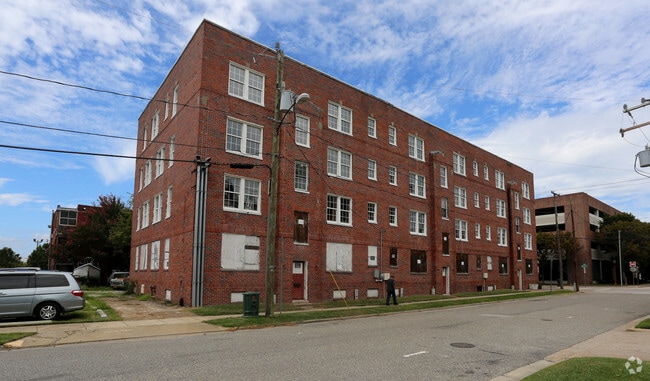
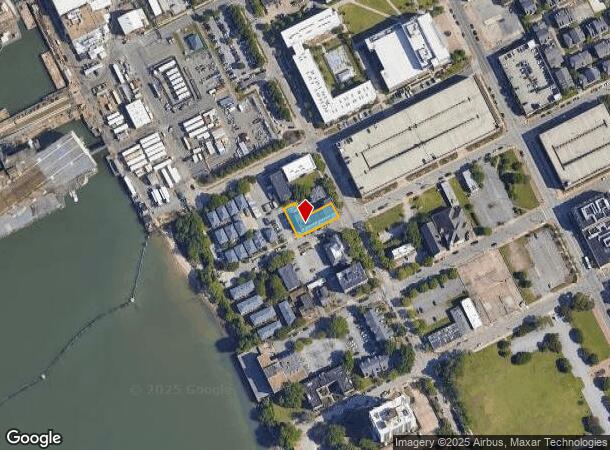
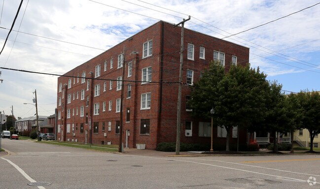
Property Record
99 30Th St, Newport News, VA 23607
NEARBY LISTINGS FOR SALE OR LEASE
Property Detail
99 30Th St
Virginia Beach-Norfolk-Newport News, VA-NC
Ward 1
310.02-04-14
7,8,9, & PT 10 50X137.50X100X37.50X50X100
Apartmenthouse5plusunits
Newport News
X
Virginia
5155270028H
10
2025
0.26 AC
2025
Downtown Newport News
030400
Hampton Roads
DEMOGRAPHICS near 99 30Th St
1 Mile
3 Mile
5 Mile
2024 Total Population
5,207
38,894
89,695
2029 Population
5,235
39,076
90,751
Pop Growth 2024-2029
+ 0.54%
+ 0.47%
+ 1.18%
Average Age
36
38
39
2024 Total Households
2,058
16,621
38,387
HH Growth 2024-2029
+ 0.73%
+ 0.37%
+ 1.16%
Median Household Inc
$37,054
$37,551
$49,882
Avg Household Size
2.10
2.20
2.30
2024 Avg HH Vehicles
1.00
1.00
2.00
Median Home Value
$149,462
$152,155
$185,035
Median Year Built
1975
1965
1966
Nearby Places
Map Layers
Map Styles
 Street
 Aerial
- Restaurants
- Banks
- Shops
- Fitness
- Groceries
PUBLIC TRANSPORTATION
COMMUTER RAIL
Newport News (Northeast Regional - Amtrak)
DRIVE
WALK
Distance
Newport News (Northeast Regional - Amtrak)
7 min
3.5 mi
AIRPORT
Newport News/Williamsburg International
DRIVE
WALK
Distance
Newport News/Williamsburg International
24 min
16.2 mi
Norfolk International
DRIVE
WALK
Distance
Norfolk International
34 min
22.3 mi
Freight Ports
Virginia Port Authority - Newport News
DRIVE
WALK
Distance
Virginia Port Authority - Newport News
1 min
0.6 mi
Nearby Properties
Address
Land Use
TOTAL SIZE
Lot Size
Zoning
Address
Land Use
TOTAL SIZE
Lot Size
Zoning
1 SF
444.26 AC
M2
Address
Land Use
TOTAL SIZE
Lot Size
Zoning
2,993 SF
169.83 AC
M2
Address
Land Use
TOTAL SIZE
Lot Size
Zoning
110,881 SF
2.30 AC
C3
Address
Land Use
TOTAL SIZE
Lot Size
Zoning
135,333 SF
8.22 AC
C3
Address
Land Use
TOTAL SIZE
Lot Size
Zoning
116,905 SF
7.42 AC
C3
Address
Land Use
TOTAL SIZE
Lot Size
Zoning
100 SF
35.50 AC
R7
Address
Land Use
TOTAL SIZE
Lot Size
Zoning
260,228 SF
37.04 AC
M1
Address
Land Use
TOTAL SIZE
Lot Size
Zoning
100 SF
26.21 AC
R7
Address
Land Use
TOTAL SIZE
Lot Size
Zoning
60,350 SF
27.53 AC
M1
Address
Land Use
TOTAL SIZE
Lot Size
Zoning
195,709 SF
1.52 AC
C3
Address
Land Use
TOTAL SIZE
Lot Size
Zoning
255,906 SF
36.57 AC
P1
Address
Land Use
TOTAL SIZE
Lot Size
Zoning
1 SF
101 AC
M2
Address
Land Use
TOTAL SIZE
Lot Size
Zoning
94,032 SF
1.64 AC
C3
Address
Land Use
TOTAL SIZE
Lot Size
Zoning
31,855 SF
4.37 AC
C3
Address
Land Use
TOTAL SIZE
Lot Size
Zoning
458,744 SF
28.01 AC
17 M-3 HEA
Address
Land Use
TOTAL SIZE
Lot Size
Zoning
11,941 SF
61.74 AC
M2
Address
Land Use
TOTAL SIZE
Lot Size
Zoning
53,551 SF
9.87 AC
P1
Address
Land Use
TOTAL SIZE
Lot Size
Zoning
1 SF
16.10 AC
M2
Address
Land Use
TOTAL SIZE
Lot Size
Zoning
133,633 SF
5.39 AC
C3
Address
Land Use
TOTAL SIZE
Lot Size
Zoning
100 SF
22.45 AC
R8 R4
Address
Land Use
TOTAL SIZE
Lot Size
Zoning
1.05 AC
C3
Address
Land Use
TOTAL SIZE
Lot Size
Zoning
1 SF
5.97 AC
M2
Address
Land Use
TOTAL SIZE
Lot Size
Zoning
10.89 AC
R8
Address
Land Use
TOTAL SIZE
Lot Size
Zoning
100 SF
1.65 AC
C3
Address
Land Use
TOTAL SIZE
Lot Size
Zoning
4.61 AC
C3
Address
Land Use
TOTAL SIZE
Lot Size
Zoning
65,964 SF
11.81 AC
17 M-3 HEA
Address
Land Use
TOTAL SIZE
Lot Size
Zoning
1,460 SF
12.40 AC
R7
Address
Land Use
TOTAL SIZE
Lot Size
Zoning
17.93 AC
R8
Address
Land Use
TOTAL SIZE
Lot Size
Zoning
18.98 AC
R8
Address
Land Use
TOTAL SIZE
Lot Size
Zoning
145,334 SF
13.26 AC
9 R-M MULT
The World's #1 Commercial Real Estate Marketplace
Connect with us
© 2025 CoStar Group
The information above has been obtained from sources believed reliable. While we do not doubt its accuracy we have not verified it and make no guarantee, warranty or representation about it. It is your responsibility to independently confirm its accuracy and completeness. Any projections, opinions, assumptions, or estimates used are for example only and do not represent the current or future performance of the property. The value of this transaction to you depends on tax and other factors which should be evaluated by your tax, financial, and legal advisors. You and your advisors should conduct a careful, independent investigation of the property to determine to your satisfaction the suitability of the property for your needs.