Property Record
99 Aiea Heights Dr, Aiea, HI 96701
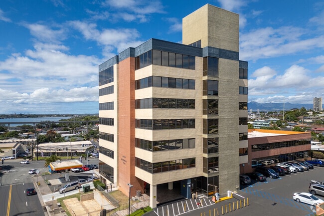
This Property Is For Sale
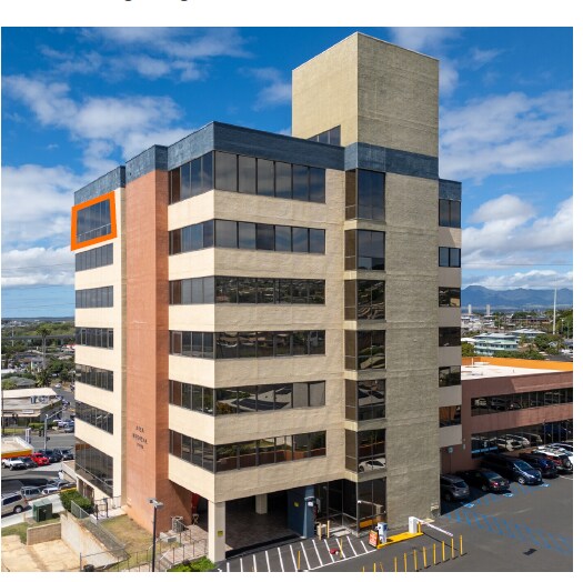
Current Lease Availabilities
NEARBY LISTINGS FOR SALE OR LEASE
Property Detail
99 Aiea Heights Dr
Urban Honolulu, HI
Aiea Medical Building
1-9-9-038-002-0009
LOT D POR LOT 13 AIEA HMSTDS (RDWY) 2,056 SF DES
Commercialnec
Honolulu
X
Hawaii
15003C0244G
13
0
1.22 AC
2025
Leeward
007816
Hawaii
693 SF
DEMOGRAPHICS near 99 Aiea Heights Dr
1 Mile
3 Mile
5 Mile
2024 Total Population
20,714
106,934
188,469
2029 Population
20,094
103,113
181,493
Pop Growth 2024-2029
(2.99%)
(3.57%)
(3.70%)
Average Age
42
40
40
2024 Total Households
7,412
34,638
55,421
HH Growth 2024-2029
(3.29%)
(4.26%)
(4.36%)
Median Household Inc
$86,273
$95,624
$94,556
Avg Household Size
2.60
2.80
3.00
2024 Avg HH Vehicles
2.00
2.00
2.00
Median Home Value
$581,210
$711,225
$722,044
Median Year Built
1975
1975
1974
Nearby Places
Map Layers
Map Styles
 Street
 Aerial
- Restaurants
- Banks
- Shops
- Fitness
- Groceries
PUBLIC TRANSPORTATION
AIRPORT
Daniel K Inouye International
DRIVE
WALK
Distance
Daniel K Inouye International
9 min
4.6 mi
Freight Ports
Honolulu Harbor, Oahu
DRIVE
WALK
Distance
Honolulu Harbor, Oahu
18 min
8.8 mi
Nearby Properties
Address
Land Use
TOTAL SIZE
Lot Size
Zoning
Address
Land Use
TOTAL SIZE
Lot Size
Zoning
355.21 AC
F-1
Address
Land Use
TOTAL SIZE
Lot Size
Zoning
163,285 SF
15.08 AC
R-7.5
Address
Land Use
TOTAL SIZE
Lot Size
Zoning
26,537 SF
2,470.86 AC
I-2
Address
Land Use
TOTAL SIZE
Lot Size
Zoning
6.20 AC
I-2
Address
Land Use
TOTAL SIZE
Lot Size
Zoning
435,857 SF
10.69 AC
BMX-3
Address
Land Use
TOTAL SIZE
Lot Size
Zoning
419,067 SF
7.34 AC
BMX-3
Address
Land Use
TOTAL SIZE
Lot Size
Zoning
154,018 SF
15.24 AC
F-1
Address
Land Use
TOTAL SIZE
Lot Size
Zoning
202,766 SF
2.84 AC
BMX-3
Address
Land Use
TOTAL SIZE
Lot Size
Zoning
164,921 SF
9.31 AC
BMX-3
Address
Land Use
TOTAL SIZE
Lot Size
Zoning
299,696 SF
16.26 AC
BMX-3
Address
Land Use
TOTAL SIZE
Lot Size
Zoning
362,266 SF
11.23 AC
B-2
Address
Land Use
TOTAL SIZE
Lot Size
Zoning
180,294 SF
10.13 AC
B-2
Address
Land Use
TOTAL SIZE
Lot Size
Zoning
203,701 SF
7.14 AC
BMX-3
Address
Land Use
TOTAL SIZE
Lot Size
Zoning
151,200 SF
5.23 AC
BMX-3
Address
Land Use
TOTAL SIZE
Lot Size
Zoning
6,788 SF
13.98 AC
BMX-3
Address
Land Use
TOTAL SIZE
Lot Size
Zoning
59,018 SF
2.76 AC
I-2
Address
Land Use
TOTAL SIZE
Lot Size
Zoning
305,962 SF
7.48 AC
B-1
Address
Land Use
TOTAL SIZE
Lot Size
Zoning
15.25 AC
I-2
Address
Land Use
TOTAL SIZE
Lot Size
Zoning
256,238 SF
13.64 AC
I-2
Address
Land Use
TOTAL SIZE
Lot Size
Zoning
26,734 SF
10.66 AC
I-2
Address
Land Use
TOTAL SIZE
Lot Size
Zoning
185,586 SF
3.59 AC
BMX-3
Address
Land Use
TOTAL SIZE
Lot Size
Zoning
396,295 SF
2.87 AC
B-2
Address
Land Use
TOTAL SIZE
Lot Size
Zoning
9.44 AC
IMX-1
Address
Land Use
TOTAL SIZE
Lot Size
Zoning
10.75 AC
I-2
Address
Land Use
TOTAL SIZE
Lot Size
Zoning
331,750 SF
0.61 AC
IMX-1
Address
Land Use
TOTAL SIZE
Lot Size
Zoning
6.20 AC
I-2
Address
Land Use
TOTAL SIZE
Lot Size
Zoning
307,720 SF
5.35 AC
B-2
Address
Land Use
TOTAL SIZE
Lot Size
Zoning
42,867 SF
341.96 AC
AG-2
Address
Land Use
TOTAL SIZE
Lot Size
Zoning
110,320 SF
6.50 AC
BMX-3
Address
Land Use
TOTAL SIZE
Lot Size
Zoning
115,294 SF
6.05 AC
BMX-3
The World's #1 Commercial Real Estate Marketplace
Connect with us
© 2025 CoStar Group
The information above has been obtained from sources believed reliable. While we do not doubt its accuracy we have not verified it and make no guarantee, warranty or representation about it. It is your responsibility to independently confirm its accuracy and completeness. Any projections, opinions, assumptions, or estimates used are for example only and do not represent the current or future performance of the property. The value of this transaction to you depends on tax and other factors which should be evaluated by your tax, financial, and legal advisors. You and your advisors should conduct a careful, independent investigation of the property to determine to your satisfaction the suitability of the property for your needs.