Property Record
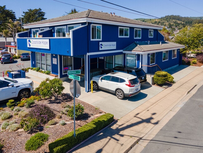
99 Avenue Alhambra, El Granada, CA 94018


NEARBY LISTINGS FOR SALE OR LEASE
-
-
View all El Granada listings for sale on LoopNet.com
Property Detail
99 Avenue Alhambra
San Francisco-San Mateo-Redwood City, CA
Granada Sub
047-091-240
LOTS 9 & 10 BLK 64 GRANADA SUB NO 5 RSM 6/50
Storebuilding
San Mateo
X
California
06081C0138F
9,10
2024
0.11 AC
2025
Peninsula Coastline
613502
San Francisco
DEMOGRAPHICS near 99 Avenue Alhambra
1 Mile
3 Mile
5 Mile
2024 Total Population
3,452
10,428
18,079
2029 Population
3,098
9,512
16,731
Pop Growth 2024-2029
(10.25%)
(8.78%)
(7.46%)
Average Age
46
45
45
2024 Total Households
1,354
3,767
6,558
HH Growth 2024-2029
(10.71%)
(9.34%)
(7.85%)
Median Household Inc
$157,193
$152,405
$143,898
Avg Household Size
2.50
2.60
2.60
2024 Avg HH Vehicles
3.00
3.00
2.00
Median Home Value
$1,131,271
$1,119,668
$1,117,259
Median Year Built
1980
1979
1978
Nearby Places
Map Layers
Map Styles
 Street
 Aerial
- Restaurants
- Banks
- Shops
- Fitness
- Groceries
PUBLIC TRANSPORTATION
AIRPORT
San Francisco International
DRIVE
WALK
Distance
San Francisco International
34 min
18.9 mi
Metro Oakland International
DRIVE
WALK
Distance
Metro Oakland International
57 min
40.4 mi
Norman Y Mineta San Jose International
DRIVE
WALK
Distance
Norman Y Mineta San Jose International
58 min
41.8 mi
SALE & LEASE HISTORY
LISTING DATE
SALE/LEASE

Jul 09, 2024
For Sale
Nearby Properties
Address
Land Use
TOTAL SIZE
Lot Size
Zoning
Address
Land Use
TOTAL SIZE
Lot Size
Zoning
94,688 SF
3.54 AC
H10000
Address
Land Use
TOTAL SIZE
Lot Size
Zoning
6.21 AC
R10S17
Address
Land Use
TOTAL SIZE
Lot Size
Zoning
20.61 AC
Address
Land Use
TOTAL SIZE
Lot Size
Zoning
164.23 AC
RM0000
Address
Land Use
TOTAL SIZE
Lot Size
Zoning
15,724 SF
0.37 AC
R300S3
Address
Land Use
TOTAL SIZE
Lot Size
Zoning
7,295 SF
1.30 AC
RM0000
Address
Land Use
TOTAL SIZE
Lot Size
Zoning
10,883 SF
0.25 AC
R20000
Address
Land Use
TOTAL SIZE
Lot Size
Zoning
24,275 SF
1.74 AC
Address
Land Use
TOTAL SIZE
Lot Size
Zoning
5,290 SF
0.31 AC
R300S
Address
Land Use
TOTAL SIZE
Lot Size
Zoning
12,675 SF
0.60 AC
Address
Land Use
TOTAL SIZE
Lot Size
Zoning
34,320 SF
1.67 AC
M10000
Address
Land Use
TOTAL SIZE
Lot Size
Zoning
0.18 AC
R30000
Address
Land Use
TOTAL SIZE
Lot Size
Zoning
5.48 AC
Address
Land Use
TOTAL SIZE
Lot Size
Zoning
178.20 AC
RM0000
Address
Land Use
TOTAL SIZE
Lot Size
Zoning
12,262 SF
0.19 AC
C100S1
Address
Land Use
TOTAL SIZE
Lot Size
Zoning
6,500 SF
0.32 AC
H10000
Address
Land Use
TOTAL SIZE
Lot Size
Zoning
Address
Land Use
TOTAL SIZE
Lot Size
Zoning
3,540 SF
0.16 AC
ML00M1
Address
Land Use
TOTAL SIZE
Lot Size
Zoning
357.13 AC
Address
Land Use
TOTAL SIZE
Lot Size
Zoning
4,209 SF
0.18 AC
Address
Land Use
TOTAL SIZE
Lot Size
Zoning
3.42 AC
R10006
Address
Land Use
TOTAL SIZE
Lot Size
Zoning
17,100 SF
0.80 AC
Address
Land Use
TOTAL SIZE
Lot Size
Zoning
9,756 SF
0.32 AC
Address
Land Use
TOTAL SIZE
Lot Size
Zoning
0.88 AC
R10000
Address
Land Use
TOTAL SIZE
Lot Size
Zoning
6,852 SF
0.34 AC
CL00C1
Address
Land Use
TOTAL SIZE
Lot Size
Zoning
4,260 SF
0.18 AC
CL00C1
Address
Land Use
TOTAL SIZE
Lot Size
Zoning
4,172 SF
0.31 AC
Address
Land Use
TOTAL SIZE
Lot Size
Zoning
0.32 AC
ML00M1
The World's #1 Commercial Real Estate Marketplace
Connect with us
© 2026 CoStar Group
The information above has been obtained from sources believed reliable. While we do not doubt its accuracy we have not verified it and make no guarantee, warranty or representation about it. It is your responsibility to independently confirm its accuracy and completeness. Any projections, opinions, assumptions, or estimates used are for example only and do not represent the current or future performance of the property. The value of this transaction to you depends on tax and other factors which should be evaluated by your tax, financial, and legal advisors. You and your advisors should conduct a careful, independent investigation of the property to determine to your satisfaction the suitability of the property for your needs.