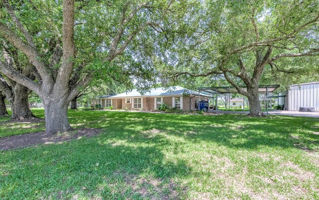
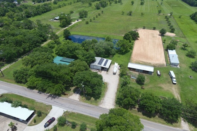
Property Record
99 County Road 99, Alvin, TX 77511
NEARBY LISTINGS FOR SALE OR LEASE
Property Detail
99 County Road 99
0177-0026-001
W J Cannan
Agriculturalland
A0177 W J CANNAN TRACT 1-3-3A ACRES 24.51
X
Brazoria
48039C0135K
Texas
2024
24.51 AC
2025
South
661400
Houston
162,100 SF
Houston-The Woodlands-Sugar Land, TX
DEMOGRAPHICS near 99 County Road 99
1 Mile
3 Mile
5 Mile
2024 Total Population
1,728
14,235
53,596
2029 Population
1,937
16,005
59,646
Pop Growth 2024-2029
+ 12.09%
+ 12.43%
+ 11.29%
Average Age
40
37
37
2024 Total Households
584
4,554
17,962
HH Growth 2024-2029
+ 12.16%
+ 12.56%
+ 11.48%
Median Household Inc
$78,511
$74,590
$81,172
Avg Household Size
2.80
3.00
2.90
2024 Avg HH Vehicles
2.00
2.00
2.00
Median Home Value
$291,891
$237,711
$250,673
Median Year Built
1987
1995
1995
Nearby Places
Map Layers
Map Styles
 Street
 Aerial
- Restaurants
- Banks
- Shops
- Fitness
- Groceries
PUBLIC TRANSPORTATION
AIRPORT
William P Hobby
DRIVE
WALK
Distance
William P Hobby
29 min
13.5 mi
Freight Ports
Port of Houston
DRIVE
WALK
Distance
Port of Houston
41 min
21.6 mi
SALE & LEASE HISTORY
LISTING DATE
SALE/LEASE

Jun 23, 2021
For Sale
Nearby Properties
Address
Land Use
TOTAL SIZE
Lot Size
Zoning
Address
Land Use
TOTAL SIZE
Lot Size
Zoning
40.52 AC
0017
Address
Land Use
TOTAL SIZE
Lot Size
Zoning
172,015 SF
18.36 AC
Address
Land Use
TOTAL SIZE
Lot Size
Zoning
41,510 SF
20.52 AC
Address
Land Use
TOTAL SIZE
Lot Size
Zoning
Address
Land Use
TOTAL SIZE
Lot Size
Zoning
48,750 SF
2.82 AC
Address
Land Use
TOTAL SIZE
Lot Size
Zoning
34,368 SF
4.32 AC
Address
Land Use
TOTAL SIZE
Lot Size
Zoning
128.92 AC
0028
Address
Land Use
TOTAL SIZE
Lot Size
Zoning
44,800 SF
3.97 AC
Address
Land Use
TOTAL SIZE
Lot Size
Zoning
3,504 SF
187.33 AC
0027
Address
Land Use
TOTAL SIZE
Lot Size
Zoning
25,200 SF
5.08 AC
Address
Land Use
TOTAL SIZE
Lot Size
Zoning
50,958 SF
10.33 AC
Address
Land Use
TOTAL SIZE
Lot Size
Zoning
21,152 SF
34.11 AC
0007
Address
Land Use
TOTAL SIZE
Lot Size
Zoning
Address
Land Use
TOTAL SIZE
Lot Size
Zoning
1,830 SF
31.44 AC
Address
Land Use
TOTAL SIZE
Lot Size
Zoning
7,460 SF
1.75 AC
0002
Address
Land Use
TOTAL SIZE
Lot Size
Zoning
24.77 AC
0025
Address
Land Use
TOTAL SIZE
Lot Size
Zoning
3,633 SF
69.42 AC
0060
Address
Land Use
TOTAL SIZE
Lot Size
Zoning
18,250 SF
9.07 AC
0034
Address
Land Use
TOTAL SIZE
Lot Size
Zoning
46,700 SF
6.41 AC
0022
Address
Land Use
TOTAL SIZE
Lot Size
Zoning
9,250 SF
1.55 AC
0004
Address
Land Use
TOTAL SIZE
Lot Size
Zoning
3,186 SF
2 AC
Address
Land Use
TOTAL SIZE
Lot Size
Zoning
75.39 AC
0023
Address
Land Use
TOTAL SIZE
Lot Size
Zoning
52,000 SF
3.86 AC
Address
Land Use
TOTAL SIZE
Lot Size
Zoning
2,920 SF
4.48 AC
0003
Address
Land Use
TOTAL SIZE
Lot Size
Zoning
2,400 SF
15.29 AC
0026
Address
Land Use
TOTAL SIZE
Lot Size
Zoning
28,122 SF
1.12 AC
0045
Address
Land Use
TOTAL SIZE
Lot Size
Zoning
9,110 SF
3.22 AC
0064
Address
Land Use
TOTAL SIZE
Lot Size
Zoning
4,800 SF
79.58 AC
0024
Address
Land Use
TOTAL SIZE
Lot Size
Zoning
12,000 SF
2.18 AC
The World's #1 Commercial Real Estate Marketplace
Connect with us
© 2025 CoStar Group
The information above has been obtained from sources believed reliable. While we do not doubt its accuracy we have not verified it and make no guarantee, warranty or representation about it. It is your responsibility to independently confirm its accuracy and completeness. Any projections, opinions, assumptions, or estimates used are for example only and do not represent the current or future performance of the property. The value of this transaction to you depends on tax and other factors which should be evaluated by your tax, financial, and legal advisors. You and your advisors should conduct a careful, independent investigation of the property to determine to your satisfaction the suitability of the property for your needs.