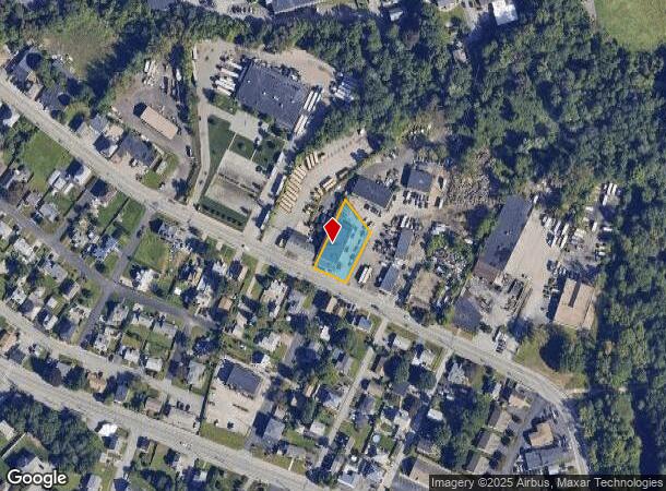
Property Record
99 Fletcher Ave, Cranston, RI 02920

NEARBY LISTINGS FOR SALE OR LEASE
Property Detail
99 Fletcher Ave
CRAN-000012-000002-001126
Providence
Industrialgeneral
Rhode Island
AE
1126
44007C0311H
0.43 AC
2025
Cranston
2025
Providence
014700
Providence-Warwick, RI-MA
13,754 SF
DEMOGRAPHICS near 99 Fletcher Ave
1 Mile
3 Mile
5 Mile
2024 Total Population
10,788
145,805
315,258
2029 Population
10,766
144,055
312,937
Pop Growth 2024-2029
(0.20%)
(1.20%)
(0.74%)
Average Age
43
39
39
2024 Total Households
4,722
55,434
121,982
HH Growth 2024-2029
(0.32%)
(1.22%)
(0.63%)
Median Household Inc
$62,109
$62,696
$64,513
Avg Household Size
2.20
2.50
2.40
2024 Avg HH Vehicles
2.00
2.00
2.00
Median Home Value
$295,618
$285,944
$295,204
Median Year Built
1972
1954
1953
Nearby Places
Map Layers
Map Styles
 Street
 Aerial
- Restaurants
- Banks
- Shops
- Fitness
- Groceries
PUBLIC TRANSPORTATION
COMMUTER RAIL
Providence (Providence/Stoughton Line - Massachusetts Bay Transportation Authority Commuter Rail (Purple Line))
DRIVE
WALK
Distance
Providence (Providence/Stoughton Line - Massachusetts Bay Transportation Authority Commuter Rail (Purple Line))
10 min
5.1 mi
SALE & LEASE HISTORY
LISTING DATE
SALE/LEASE

Sep 20, 2019
For Lease
May 26, 2019
For Lease
Dec 10, 2024
For Lease
Aug 27, 2018
For Lease
Nearby Properties
Address
Land Use
TOTAL SIZE
Lot Size
Zoning
Address
Land Use
TOTAL SIZE
Lot Size
Zoning
9.06 AC
PS
Address
Land Use
TOTAL SIZE
Lot Size
Zoning
13.40 AC
C3
Address
Land Use
TOTAL SIZE
Lot Size
Zoning
91.15 AC
PUD
Address
Land Use
TOTAL SIZE
Lot Size
Zoning
4,954 SF
11.22 AC
C5
Address
Land Use
TOTAL SIZE
Lot Size
Zoning
136,906 SF
4.96 AC
PS
Address
Land Use
TOTAL SIZE
Lot Size
Zoning
333,161 SF
25.85 AC
B1
Address
Land Use
TOTAL SIZE
Lot Size
Zoning
32.30 AC
I
Address
Land Use
TOTAL SIZE
Lot Size
Zoning
27.47 AC
S1
Address
Land Use
TOTAL SIZE
Lot Size
Zoning
27.46 AC
C4
Address
Land Use
TOTAL SIZE
Lot Size
Zoning
30.14 AC
R40
Address
Land Use
TOTAL SIZE
Lot Size
Zoning
13,542 SF
95.26 AC
R10
Address
Land Use
TOTAL SIZE
Lot Size
Zoning
15.57 AC
M-MU-7
Address
Land Use
TOTAL SIZE
Lot Size
Zoning
15.35 AC
MPD
Address
Land Use
TOTAL SIZE
Lot Size
Zoning
63.33 AC
OS
Address
Land Use
TOTAL SIZE
Lot Size
Zoning
10.78 AC
MPD
Address
Land Use
TOTAL SIZE
Lot Size
Zoning
57,068 SF
3.73 AC
Address
Land Use
TOTAL SIZE
Lot Size
Zoning
5.54 AC
R-4
Address
Land Use
TOTAL SIZE
Lot Size
Zoning
3.07 AC
M-MU-7
Address
Land Use
TOTAL SIZE
Lot Size
Zoning
Address
Land Use
TOTAL SIZE
Lot Size
Zoning
2,308 SF
12.82 AC
B2
Address
Land Use
TOTAL SIZE
Lot Size
Zoning
12.81 AC
A8
Address
Land Use
TOTAL SIZE
Lot Size
Zoning
138,056 SF
3.22 AC
PS
Address
Land Use
TOTAL SIZE
Lot Size
Zoning
81,129 SF
5.75 AC
A8
Address
Land Use
TOTAL SIZE
Lot Size
Zoning
11.17 AC
A20
Address
Land Use
TOTAL SIZE
Lot Size
Zoning
138,213 SF
1.61 AC
MPD
Address
Land Use
TOTAL SIZE
Lot Size
Zoning
10.76 AC
R-4
Address
Land Use
TOTAL SIZE
Lot Size
Zoning
184,286 SF
2.91 AC
C1
Address
Land Use
TOTAL SIZE
Lot Size
Zoning
2.36 AC
PS
Address
Land Use
TOTAL SIZE
Lot Size
Zoning
64,882 SF
0.82 AC
R-2
Address
Land Use
TOTAL SIZE
Lot Size
Zoning
105,054 SF
18.73 AC
A6
The World's #1 Commercial Real Estate Marketplace
Connect with us
© 2026 CoStar Group
The information above has been obtained from sources believed reliable. While we do not doubt its accuracy we have not verified it and make no guarantee, warranty or representation about it. It is your responsibility to independently confirm its accuracy and completeness. Any projections, opinions, assumptions, or estimates used are for example only and do not represent the current or future performance of the property. The value of this transaction to you depends on tax and other factors which should be evaluated by your tax, financial, and legal advisors. You and your advisors should conduct a careful, independent investigation of the property to determine to your satisfaction the suitability of the property for your needs.