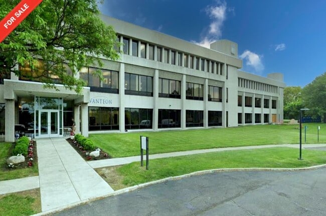
Property Record
99 Garnsey Rd, Pittsford, NY 14534


NEARBY LISTINGS FOR SALE OR LEASE
Property Detail
99 Garnsey Rd
Rochester, NY
Map Of Citibank Land Title Survey
264489-179-040-0001-005-000
0064-12-04
Officebuilding
Monroe
X
New York
36055C0387G
5.000
2025
26.13 AC
2024
Southeast
011708
Rochester
101,804 SF
DEMOGRAPHICS near 99 Garnsey Rd
1 Mile
3 Mile
5 Mile
2024 Total Population
3,427
31,849
84,514
2029 Population
3,386
31,615
83,435
Pop Growth 2024-2029
(1.20%)
(0.73%)
(1.28%)
Average Age
45
45
44
2024 Total Households
1,302
12,752
33,930
HH Growth 2024-2029
(1.31%)
(0.78%)
(1.41%)
Median Household Inc
$153,346
$116,929
$104,731
Avg Household Size
2.60
2.40
2.40
2024 Avg HH Vehicles
2.00
2.00
2.00
Median Home Value
$315,454
$272,549
$275,767
Median Year Built
1979
1974
1974
Nearby Places
Map Layers
Map Styles
 Street
 Aerial
- Restaurants
- Banks
- Shops
- Fitness
- Groceries
PUBLIC TRANSPORTATION
AIRPORT
Frederick Douglass/Greater Rochester International
DRIVE
WALK
Distance
Frederick Douglass/Greater Rochester International
25 min
14.0 mi
SALE & LEASE HISTORY
LISTING DATE
SALE/LEASE

Aug 29, 2023
For Sale
Nearby Properties
Address
Land Use
TOTAL SIZE
Lot Size
Zoning
Address
Land Use
TOTAL SIZE
Lot Size
Zoning
667,703 SF
89.60 AC
COMM
Address
Land Use
TOTAL SIZE
Lot Size
Zoning
239,694 SF
94.46 AC
COMM
Address
Land Use
TOTAL SIZE
Lot Size
Zoning
177,828 SF
36.90 AC
Address
Land Use
TOTAL SIZE
Lot Size
Zoning
191,117 SF
31.86 AC
Address
Land Use
TOTAL SIZE
Lot Size
Zoning
105,768 SF
51.10 AC
R-B
Address
Land Use
TOTAL SIZE
Lot Size
Zoning
196,411 SF
23.40 AC
COMMERCIAL
Address
Land Use
TOTAL SIZE
Lot Size
Zoning
150,814 SF
20.38 AC
INDUSTRIAL
Address
Land Use
TOTAL SIZE
Lot Size
Zoning
145,904 SF
24.20 AC
PDD
Address
Land Use
TOTAL SIZE
Lot Size
Zoning
211,069 SF
22.70 AC
COMM
Address
Land Use
TOTAL SIZE
Lot Size
Zoning
7,282 SF
24.04 AC
APT
Address
Land Use
TOTAL SIZE
Lot Size
Zoning
114,692 SF
27.10 AC
RES B
Address
Land Use
TOTAL SIZE
Lot Size
Zoning
107,120 SF
9.01 AC
INDUSTRIAL
Address
Land Use
TOTAL SIZE
Lot Size
Zoning
135,844 SF
8.40 AC
COMM
Address
Land Use
TOTAL SIZE
Lot Size
Zoning
1,728 SF
85.30 AC
Address
Land Use
TOTAL SIZE
Lot Size
Zoning
72,747 SF
5.98 AC
Address
Land Use
TOTAL SIZE
Lot Size
Zoning
6,768 SF
14.32 AC
APT
Address
Land Use
TOTAL SIZE
Lot Size
Zoning
155,915 SF
20.80 AC
PDD
Address
Land Use
TOTAL SIZE
Lot Size
Zoning
11,630 SF
15.80 AC
APT
Address
Land Use
TOTAL SIZE
Lot Size
Zoning
75,624 SF
19.20 AC
Address
Land Use
TOTAL SIZE
Lot Size
Zoning
122,000 SF
11.39 AC
COMMERCIAL
Address
Land Use
TOTAL SIZE
Lot Size
Zoning
130,674 SF
42 AC
RES B
Address
Land Use
TOTAL SIZE
Lot Size
Zoning
123,500 SF
8.80 AC
PDD
Address
Land Use
TOTAL SIZE
Lot Size
Zoning
75,677 SF
47.69 AC
RES B
Address
Land Use
TOTAL SIZE
Lot Size
Zoning
117,445 SF
11.86 AC
PDD
Address
Land Use
TOTAL SIZE
Lot Size
Zoning
122,402 SF
10 AC
PDD
Address
Land Use
TOTAL SIZE
Lot Size
Zoning
112,061 SF
20.16 AC
COMM
Address
Land Use
TOTAL SIZE
Lot Size
Zoning
114,667 SF
10.30 AC
PDD
Address
Land Use
TOTAL SIZE
Lot Size
Zoning
105,726 SF
13.80 AC
RES B
Address
Land Use
TOTAL SIZE
Lot Size
Zoning
174,700 SF
15.90 AC
COMM
The World's #1 Commercial Real Estate Marketplace
Connect with us
© 2025 CoStar Group
The information above has been obtained from sources believed reliable. While we do not doubt its accuracy we have not verified it and make no guarantee, warranty or representation about it. It is your responsibility to independently confirm its accuracy and completeness. Any projections, opinions, assumptions, or estimates used are for example only and do not represent the current or future performance of the property. The value of this transaction to you depends on tax and other factors which should be evaluated by your tax, financial, and legal advisors. You and your advisors should conduct a careful, independent investigation of the property to determine to your satisfaction the suitability of the property for your needs.