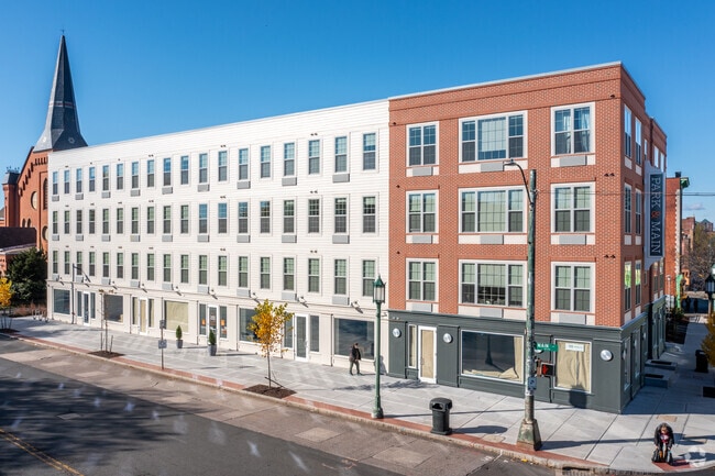
Property Record
87 Main St, Hartford, CT 06106
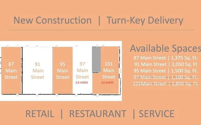
Current Lease Availabilities
NEARBY LISTINGS FOR SALE OR LEASE
Property Detail
87 Main St
HTFD-000248-000555-000073
Hartford
Governmentalpublicusegeneral
Connecticut
X
105
09003C0368G
0.60 AC
0
South Green
2025
Hartford
502800
Hartford-West Hartford-East Hartford, CT
30,910 SF
DEMOGRAPHICS near 87 Main St
1 Mile
3 Mile
5 Mile
2024 Total Population
30,654
152,427
276,014
2029 Population
31,070
151,746
274,557
Pop Growth 2024-2029
+ 1.36%
(0.45%)
(0.53%)
Average Age
35
37
39
2024 Total Households
12,881
62,134
110,288
HH Growth 2024-2029
+ 1.93%
(0.26%)
(0.45%)
Median Household Inc
$39,349
$44,831
$61,685
Avg Household Size
2.20
2.30
2.40
2024 Avg HH Vehicles
1.00
1.00
1.00
Median Home Value
$227,825
$208,726
$247,888
Median Year Built
1959
1953
1955
Nearby Places
- Restaurants
- Banks
- Shops
- Fitness
- Groceries
PUBLIC TRANSPORTATION
COMMUTER RAIL
DRIVE
WALK
Distance
2 min
20 min
1.0 mi
DRIVE
WALK
Distance
2 min
20 min
1.0 mi
AIRPORT
Bradley International
DRIVE
WALK
Distance
Bradley International
33 min
18.2 mi
Tweed/New Haven
DRIVE
WALK
Distance
Tweed/New Haven
55 min
39.1 mi
Freight Ports
Port of New Haven
DRIVE
WALK
Distance
Port of New Haven
51 min
36.8 mi
Nearby Properties
Address
Land Use
TOTAL SIZE
Lot Size
Zoning
Address
Land Use
TOTAL SIZE
Lot Size
Zoning
147,644 SF
0.19 AC
CAMP
Address
Land Use
TOTAL SIZE
Lot Size
Zoning
173,601 SF
1.56 AC
DT-1
Address
Land Use
TOTAL SIZE
Lot Size
Zoning
516,804 SF
32.98 AC
CAMP
Address
Land Use
TOTAL SIZE
Lot Size
Zoning
482,566 SF
0.65 AC
DT-2
Address
Land Use
TOTAL SIZE
Lot Size
Zoning
15.73 AC
CAMP
Address
Land Use
TOTAL SIZE
Lot Size
Zoning
4.13 AC
DT-1
Address
Land Use
TOTAL SIZE
Lot Size
Zoning
1.45 AC
CAMP
Address
Land Use
TOTAL SIZE
Lot Size
Zoning
213,017 SF
6.21 AC
DT-3
Address
Land Use
TOTAL SIZE
Lot Size
Zoning
149.23 AC
DDD1
Address
Land Use
TOTAL SIZE
Lot Size
Zoning
2.90 AC
DT-2
Address
Land Use
TOTAL SIZE
Lot Size
Zoning
69.42 AC
CT R
Address
Land Use
TOTAL SIZE
Lot Size
Zoning
8.89 AC
MX-2
Address
Land Use
TOTAL SIZE
Lot Size
Zoning
29.35 AC
CAMP
Address
Land Use
TOTAL SIZE
Lot Size
Zoning
2,500 SF
74.98 AC
I-2
Address
Land Use
TOTAL SIZE
Lot Size
Zoning
584 AC
OS
Address
Land Use
TOTAL SIZE
Lot Size
Zoning
1,125,149 SF
1.14 AC
DT-1
Address
Land Use
TOTAL SIZE
Lot Size
Zoning
205,719 SF
12.15 AC
MX-2
Address
Land Use
TOTAL SIZE
Lot Size
Zoning
28.02 AC
CAMP
Address
Land Use
TOTAL SIZE
Lot Size
Zoning
9.92 AC
DDD1
Address
Land Use
TOTAL SIZE
Lot Size
Zoning
416,762 SF
20 AC
CAMP
Address
Land Use
TOTAL SIZE
Lot Size
Zoning
14.56 AC
SDD/BG
Address
Land Use
TOTAL SIZE
Lot Size
Zoning
20.41 AC
MX-2
Address
Land Use
TOTAL SIZE
Lot Size
Zoning
235,476 SF
198.32 AC
CT R
Address
Land Use
TOTAL SIZE
Lot Size
Zoning
197,704 SF
1.82 AC
CAMP
Address
Land Use
TOTAL SIZE
Lot Size
Zoning
109,276 SF
11 AC
DDD1
Address
Land Use
TOTAL SIZE
Lot Size
Zoning
40,632 SF
1.10 AC
NX-1
Address
Land Use
TOTAL SIZE
Lot Size
Zoning
4.76 AC
MX-2
Address
Land Use
TOTAL SIZE
Lot Size
Zoning
6.63 AC
DT-1
Address
Land Use
TOTAL SIZE
Lot Size
Zoning
2.13 AC
DT-1
Address
Land Use
TOTAL SIZE
Lot Size
Zoning
4.50 AC
DT-1
The World's #1 Commercial Real Estate Marketplace
Connect with us
© 2025 CoStar Group
The information above has been obtained from sources believed reliable. While we do not doubt its accuracy we have not verified it and make no guarantee, warranty or representation about it. It is your responsibility to independently confirm its accuracy and completeness. Any projections, opinions, assumptions, or estimates used are for example only and do not represent the current or future performance of the property. The value of this transaction to you depends on tax and other factors which should be evaluated by your tax, financial, and legal advisors. You and your advisors should conduct a careful, independent investigation of the property to determine to your satisfaction the suitability of the property for your needs.