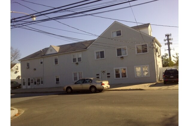
Property Record
99 Nassau Ln, Island Park, NY 11558
NEARBY LISTINGS FOR SALE OR LEASE
Property Detail
99 Nassau Ln
Nassau County-Suffolk County, NY
Island Park Long Beach Inc
2021-43-050-00-0071-0
TOWN #1 SCH DIST 031
Apartment
Nassau
AE
New York
36059C0307G
71
2025
0.32 AC
2025
Island Park
416202
Long Island (New York)
9,240 SF
DEMOGRAPHICS near 99 Nassau Ln
1 Mile
3 Mile
5 Mile
2024 Total Population
11,976
85,897
277,473
2029 Population
11,621
84,150
272,044
Pop Growth 2024-2029
(2.96%)
(2.03%)
(1.96%)
Average Age
43
43
41
2024 Total Households
4,185
33,531
97,417
HH Growth 2024-2029
(3.15%)
(2.00%)
(2.01%)
Median Household Inc
$107,379
$117,375
$118,608
Avg Household Size
2.70
2.50
2.70
2024 Avg HH Vehicles
2.00
2.00
2.00
Median Home Value
$671,019
$672,038
$661,247
Median Year Built
1959
1957
1953
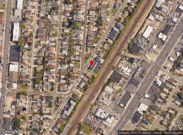
Nearby Places
Map Layers
Map Styles
 Street
 Aerial
- Restaurants
- Banks
- Shops
- Fitness
- Groceries
PUBLIC TRANSPORTATION
COMMUTER RAIL
Island Park Station (Long Beach Branch - Long Island Rail Road)
DRIVE
WALK
Distance
Island Park Station (Long Beach Branch - Long Island Rail Road)
1 min
13 min
0.3 mi
Long Beach Station (Long Beach Branch - Long Island Rail Road)
DRIVE
WALK
Distance
Long Beach Station (Long Beach Branch - Long Island Rail Road)
4 min
1.8 mi
AIRPORT
John F Kennedy International
DRIVE
WALK
Distance
John F Kennedy International
24 min
14.0 mi
LaGuardia
DRIVE
WALK
Distance
LaGuardia
34 min
20.9 mi
Newark Liberty International
DRIVE
WALK
Distance
Newark Liberty International
61 min
40.7 mi
Freight Ports
NY - Red Hook Container Terminal
DRIVE
WALK
Distance
NY - Red Hook Container Terminal
45 min
25.4 mi
Nearby Properties
Address
Land Use
TOTAL SIZE
Lot Size
Zoning
Address
Land Use
TOTAL SIZE
Lot Size
Zoning
Address
Land Use
TOTAL SIZE
Lot Size
Zoning
Address
Land Use
TOTAL SIZE
Lot Size
Zoning
648 SF
111.40 AC
Address
Land Use
TOTAL SIZE
Lot Size
Zoning
88.30 AC
Address
Land Use
TOTAL SIZE
Lot Size
Zoning
350.74 AC
Address
Land Use
TOTAL SIZE
Lot Size
Zoning
336,450 SF
139.91 AC
Address
Land Use
TOTAL SIZE
Lot Size
Zoning
30,700 SF
88.36 AC
Address
Land Use
TOTAL SIZE
Lot Size
Zoning
26,726 SF
135.53 AC
Address
Land Use
TOTAL SIZE
Lot Size
Zoning
58,400 SF
58.17 AC
Address
Land Use
TOTAL SIZE
Lot Size
Zoning
133.85 AC
Address
Land Use
TOTAL SIZE
Lot Size
Zoning
195,575 SF
35.93 AC
Address
Land Use
TOTAL SIZE
Lot Size
Zoning
197,920 SF
16.50 AC
Address
Land Use
TOTAL SIZE
Lot Size
Zoning
92.92 AC
Address
Land Use
TOTAL SIZE
Lot Size
Zoning
80.84 AC
Address
Land Use
TOTAL SIZE
Lot Size
Zoning
Address
Land Use
TOTAL SIZE
Lot Size
Zoning
151,757 SF
34.38 AC
Address
Land Use
TOTAL SIZE
Lot Size
Zoning
99,904 SF
20.17 AC
Address
Land Use
TOTAL SIZE
Lot Size
Zoning
357,868 SF
24.92 AC
Address
Land Use
TOTAL SIZE
Lot Size
Zoning
66.41 AC
Address
Land Use
TOTAL SIZE
Lot Size
Zoning
6,258 SF
34.59 AC
Address
Land Use
TOTAL SIZE
Lot Size
Zoning
1,664 SF
32.13 AC
Address
Land Use
TOTAL SIZE
Lot Size
Zoning
61.52 AC
Address
Land Use
TOTAL SIZE
Lot Size
Zoning
61.52 AC
Address
Land Use
TOTAL SIZE
Lot Size
Zoning
58.86 AC
Address
Land Use
TOTAL SIZE
Lot Size
Zoning
60.30 AC
Address
Land Use
TOTAL SIZE
Lot Size
Zoning
484,552 SF
11.56 AC
Address
Land Use
TOTAL SIZE
Lot Size
Zoning
59,715 SF
12.81 AC
Address
Land Use
TOTAL SIZE
Lot Size
Zoning
37.90 AC
Address
Land Use
TOTAL SIZE
Lot Size
Zoning
120,000 SF
39.77 AC
Address
Land Use
TOTAL SIZE
Lot Size
Zoning
225,176 SF
15.55 AC
The World's #1 Commercial Real Estate Marketplace
Connect with us
© 2025 CoStar Group
The information above has been obtained from sources believed reliable. While we do not doubt its accuracy we have not verified it and make no guarantee, warranty or representation about it. It is your responsibility to independently confirm its accuracy and completeness. Any projections, opinions, assumptions, or estimates used are for example only and do not represent the current or future performance of the property. The value of this transaction to you depends on tax and other factors which should be evaluated by your tax, financial, and legal advisors. You and your advisors should conduct a careful, independent investigation of the property to determine to your satisfaction the suitability of the property for your needs.