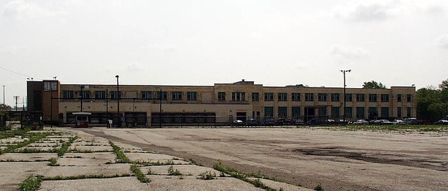
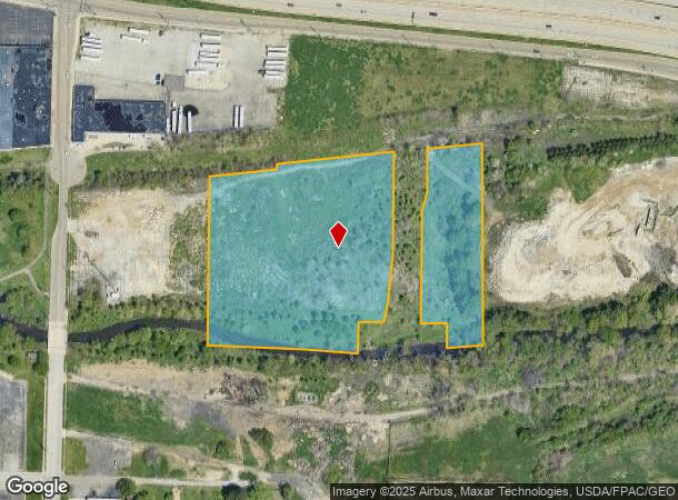
Property Record
99 S Seiberling St, Akron, OH 44305

NEARBY LISTINGS FOR SALE OR LEASE
Property Detail
99 S Seiberling St
Akron, OH
Springfield 03
67-61032
TR 3 LOT A S OF RR E OF E OF SEIBERLING ST 8.00 AC LESS PT FOR RD PENDING EPA ABMT
Industrialgeneral
Summit
AE
Ohio
39153C0211F
a
2023
6.66 AC
2025
Akron
502700
Cleveland
227,140 SF
DEMOGRAPHICS near 99 S Seiberling St
1 mile
3 mile
5 mile
2024 Total Population
10,478
87,122
195,507
2029 Population
10,449
86,737
194,240
Pop Growth 2024-2029
(0.28%)
(0.44%)
(0.65%)
Average Age
38
38
39
2024 Total Households
4,372
36,656
83,287
HH Growth 2024-2029
(0.37%)
(0.46%)
(0.70%)
Median Household Inc
$46,716
$43,026
$44,377
Avg Household Size
2.30
2.20
2.20
2024 Avg HH Vehicles
2.00
2.00
2.00
Median Home Value
$81,928
$91,930
$112,987
Median Year Built
1950
1954
1955
Nearby Places
Map Layers
Map Styles
 Street
 Aerial
Transit
 Traffic
 Biking
Places
Listings with unknown addresses are not visible on the map
- Restaurants
- Banks
- Shops
- Fitness
- Groceries
PUBLIC TRANSPORTATION
COMMUTER RAIL
Akron Northside (National Park Scenic Railway - Cuyahoga Valley Scenic Railroad)
Drive
Walk
Distance
Akron Northside (National Park Scenic Railway - Cuyahoga Valley Scenic Railroad)
10 min
4.8 mi
Big Bend (National Park Scenic Railway - Cuyahoga Valley Scenic Railroad)
Drive
Walk
Distance
Big Bend (National Park Scenic Railway - Cuyahoga Valley Scenic Railroad)
18 min
8.2 mi
AIRPORT
Akron-Canton Regional
Drive
Walk
Distance
Akron-Canton Regional
21 min
14.5 mi
Freight Ports
Port of Toledo
Drive
Walk
Distance
Port of Toledo
165 min
139.1 mi
Nearby Properties
Address
Land Use
TOTAL SIZE
Lot Size
Zoning
Address
Land Use
TOTAL SIZE
Lot Size
Zoning
1,811,279 SF
38.71 AC
Address
Land Use
TOTAL SIZE
Lot Size
Zoning
Address
Land Use
TOTAL SIZE
Lot Size
Zoning
225,751 SF
0.16 AC
Address
Land Use
TOTAL SIZE
Lot Size
Zoning
404,207 SF
2.19 AC
Address
Land Use
TOTAL SIZE
Lot Size
Zoning
203,458 SF
10.41 AC
Address
Land Use
TOTAL SIZE
Lot Size
Zoning
264,753 SF
22.87 AC
Address
Land Use
TOTAL SIZE
Lot Size
Zoning
Address
Land Use
TOTAL SIZE
Lot Size
Zoning
Address
Land Use
TOTAL SIZE
Lot Size
Zoning
3.15 AC
Address
Land Use
TOTAL SIZE
Lot Size
Zoning
186,867 SF
1.48 AC
Address
Land Use
TOTAL SIZE
Lot Size
Zoning
423,125 SF
5.57 AC
Address
Land Use
TOTAL SIZE
Lot Size
Zoning
Address
Land Use
TOTAL SIZE
Lot Size
Zoning
0.41 AC
Address
Land Use
TOTAL SIZE
Lot Size
Zoning
183,227 SF
4.29 AC
Address
Land Use
TOTAL SIZE
Lot Size
Zoning
347,139 SF
9.65 AC
Address
Land Use
TOTAL SIZE
Lot Size
Zoning
51,702 SF
0.36 AC
Address
Land Use
TOTAL SIZE
Lot Size
Zoning
3.16 AC
Address
Land Use
TOTAL SIZE
Lot Size
Zoning
66,302 SF
10.87 AC
Address
Land Use
TOTAL SIZE
Lot Size
Zoning
52,803 SF
1.33 AC
Address
Land Use
TOTAL SIZE
Lot Size
Zoning
275,025 SF
0.98 AC
Address
Land Use
TOTAL SIZE
Lot Size
Zoning
232,791 SF
8.16 AC
Address
Land Use
TOTAL SIZE
Lot Size
Zoning
145,684 SF
27.98 AC
Address
Land Use
TOTAL SIZE
Lot Size
Zoning
215,975 SF
5.76 AC
Address
Land Use
TOTAL SIZE
Lot Size
Zoning
245,911 SF
14.48 AC
Address
Land Use
TOTAL SIZE
Lot Size
Zoning
82,418 SF
1.52 AC
Address
Land Use
TOTAL SIZE
Lot Size
Zoning
115,567 SF
9.06 AC
Address
Land Use
TOTAL SIZE
Lot Size
Zoning
52,949 SF
2.35 AC
Address
Land Use
TOTAL SIZE
Lot Size
Zoning
123,088 SF
1.30 AC
Address
Land Use
TOTAL SIZE
Lot Size
Zoning
248,793 SF
0.27 AC
Address
Land Use
TOTAL SIZE
Lot Size
Zoning
2.20 AC
The World's #1 Commercial Real Estate Marketplace
Connect with us
© 2026 CoStar Group
The information above has been obtained from sources believed reliable. While we do not doubt its accuracy we have not verified it and make no guarantee, warranty or representation about it. It is your responsibility to independently confirm its accuracy and completeness. Any projections, opinions, assumptions, or estimates used are for example only and do not represent the current or future performance of the property. The value of this transaction to you depends on tax and other factors which should be evaluated by your tax, financial, and legal advisors. You and your advisors should conduct a careful, independent investigation of the property to determine to your satisfaction the suitability of the property for your needs.