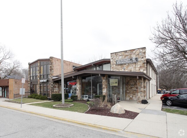
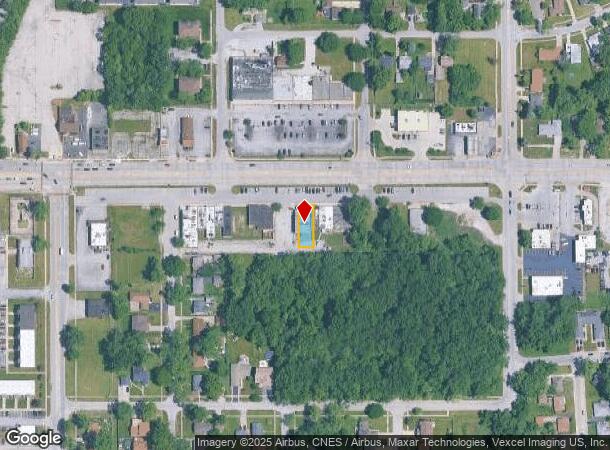
Property Record
99 Sauk Trl, Richton Park, IL 60471

NEARBY LISTINGS FOR SALE OR LEASE
Property Detail
99 Sauk Trl
Chicago-Naperville-Elgin, IL-IN-WI
Reuter &Cos Richton
31-35-103-001-0000
O (REUTER) &COS (RICHTON) PARK SUB OF PT EH WH SEC 35-35-13
Taxexempt
Cook
X
Illinois
17031C0802J
9
2022
0.13 AC
2024
Far South
830007
Chicago
4,855 SF
DEMOGRAPHICS near 99 Sauk Trl
1 Mile
3 Mile
5 Mile
2024 Total Population
12,574
60,164
145,906
2029 Population
12,389
59,199
143,680
Pop Growth 2024-2029
(1.47%)
(1.60%)
(1.53%)
Average Age
40
41
40
2024 Total Households
5,031
23,187
54,005
HH Growth 2024-2029
(1.85%)
(1.94%)
(1.81%)
Median Household Inc
$54,885
$62,088
$67,548
Avg Household Size
2.40
2.50
2.60
2024 Avg HH Vehicles
2.00
2.00
2.00
Median Home Value
$118,790
$140,655
$158,867
Median Year Built
1970
1970
1971
Nearby Places
Map Layers
Map Styles
 Street
 Aerial
- Restaurants
- Banks
- Shops
- Fitness
- Groceries
PUBLIC TRANSPORTATION
COMMUTER RAIL
Richton Park Station (Metra Electric Line - Northeast Illinois Regional Commuter Railroad (Metra))
DRIVE
WALK
Distance
Richton Park Station (Metra Electric Line - Northeast Illinois Regional Commuter Railroad (Metra))
3 min
10 min
0.5 mi
Matteson Station (Metra Electric Line - Northeast Illinois Regional Commuter Railroad (Metra))
DRIVE
WALK
Distance
Matteson Station (Metra Electric Line - Northeast Illinois Regional Commuter Railroad (Metra))
4 min
1.3 mi
AIRPORT
Chicago Midway International
DRIVE
WALK
Distance
Chicago Midway International
40 min
23.6 mi
Freight Ports
Port Milwaukee
DRIVE
WALK
Distance
Port Milwaukee
147 min
117.3 mi
Nearby Properties
Address
Land Use
TOTAL SIZE
Lot Size
Zoning
Address
Land Use
TOTAL SIZE
Lot Size
Zoning
757,504 SF
46.30 AC
Address
Land Use
TOTAL SIZE
Lot Size
Zoning
575,024 SF
39.03 AC
Address
Land Use
TOTAL SIZE
Lot Size
Zoning
Address
Land Use
TOTAL SIZE
Lot Size
Zoning
192,701 SF
31.69 AC
Address
Land Use
TOTAL SIZE
Lot Size
Zoning
37.62 AC
Address
Land Use
TOTAL SIZE
Lot Size
Zoning
455,870 SF
23.32 AC
Address
Land Use
TOTAL SIZE
Lot Size
Zoning
Address
Land Use
TOTAL SIZE
Lot Size
Zoning
Address
Land Use
TOTAL SIZE
Lot Size
Zoning
Address
Land Use
TOTAL SIZE
Lot Size
Zoning
471,716 SF
29.58 AC
Address
Land Use
TOTAL SIZE
Lot Size
Zoning
Address
Land Use
TOTAL SIZE
Lot Size
Zoning
70.02 AC
Address
Land Use
TOTAL SIZE
Lot Size
Zoning
300,399 SF
26.50 AC
Address
Land Use
TOTAL SIZE
Lot Size
Zoning
11.84 AC
Address
Land Use
TOTAL SIZE
Lot Size
Zoning
150,289 SF
16.40 AC
Address
Land Use
TOTAL SIZE
Lot Size
Zoning
192,369 SF
22.05 AC
Address
Land Use
TOTAL SIZE
Lot Size
Zoning
224,611 SF
0.90 AC
Address
Land Use
TOTAL SIZE
Lot Size
Zoning
322,629 SF
53.73 AC
Address
Land Use
TOTAL SIZE
Lot Size
Zoning
2.94 AC
Address
Land Use
TOTAL SIZE
Lot Size
Zoning
15.23 AC
Address
Land Use
TOTAL SIZE
Lot Size
Zoning
2.04 AC
Address
Land Use
TOTAL SIZE
Lot Size
Zoning
Address
Land Use
TOTAL SIZE
Lot Size
Zoning
183,041 SF
18.71 AC
Address
Land Use
TOTAL SIZE
Lot Size
Zoning
250,656 SF
Address
Land Use
TOTAL SIZE
Lot Size
Zoning
130,753 SF
8.12 AC
Address
Land Use
TOTAL SIZE
Lot Size
Zoning
268,051 SF
40.82 AC
Address
Land Use
TOTAL SIZE
Lot Size
Zoning
133,342 SF
11.63 AC
Address
Land Use
TOTAL SIZE
Lot Size
Zoning
96,255 SF
12.01 AC
Address
Land Use
TOTAL SIZE
Lot Size
Zoning
155,000 SF
10.18 AC
Address
Land Use
TOTAL SIZE
Lot Size
Zoning
72,668 SF
3 AC
The World's #1 Commercial Real Estate Marketplace
Connect with us
© 2025 CoStar Group
The information above has been obtained from sources believed reliable. While we do not doubt its accuracy we have not verified it and make no guarantee, warranty or representation about it. It is your responsibility to independently confirm its accuracy and completeness. Any projections, opinions, assumptions, or estimates used are for example only and do not represent the current or future performance of the property. The value of this transaction to you depends on tax and other factors which should be evaluated by your tax, financial, and legal advisors. You and your advisors should conduct a careful, independent investigation of the property to determine to your satisfaction the suitability of the property for your needs.