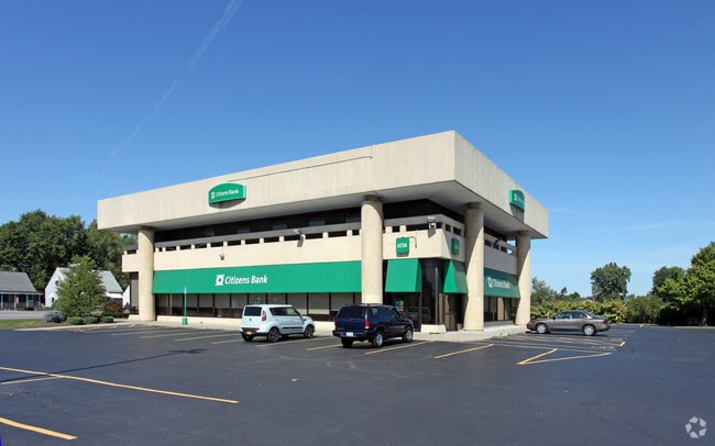
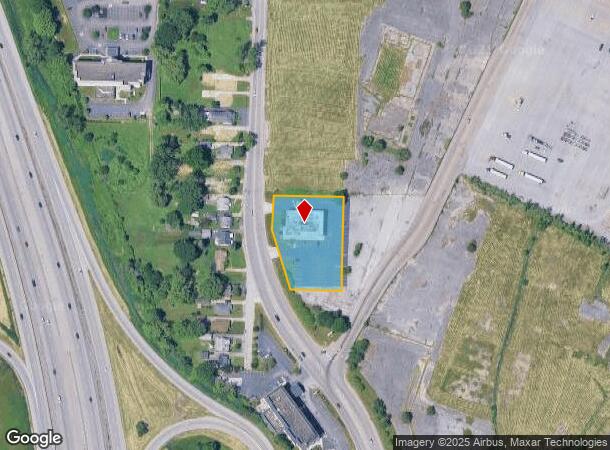
Property Record
99 Slade Ave, Buffalo, NY 14224
NEARBY LISTINGS FOR SALE OR LEASE
Property Detail
99 Slade Ave
146800-143-050-0001-034-000
SL'S-9,9A,10,11 SL-12 PT-13 276.75 X 203.05
Financialbuilding
Erie
X
New York
36029C0333H
34.000
2025
1.10 AC
2024
South
011800
Buffalo/Niagara Falls
10,744 SF
Buffalo-Cheektowaga-Niagara Falls, NY
DEMOGRAPHICS near 99 Slade Ave
1 Mile
3 Mile
5 Mile
2024 Total Population
9,700
91,170
180,464
2029 Population
9,569
89,416
177,753
Pop Growth 2024-2029
(1.35%)
(1.92%)
(1.50%)
Average Age
42
41
42
2024 Total Households
4,344
39,915
79,558
HH Growth 2024-2029
(1.34%)
(1.98%)
(1.53%)
Median Household Inc
$67,925
$59,904
$57,735
Avg Household Size
2.10
2.20
2.20
2024 Avg HH Vehicles
2.00
2.00
2.00
Median Home Value
$158,611
$158,352
$161,203
Median Year Built
1954
1953
1956
Nearby Places
- Restaurants
- Banks
- Shops
- Fitness
- Groceries
PUBLIC TRANSPORTATION
COMMUTER RAIL
DRIVE
WALK
Distance
12 min
6.4 mi
DRIVE
WALK
Distance
15 min
8.8 mi
AIRPORT
Buffalo Niagara International
DRIVE
WALK
Distance
Buffalo Niagara International
20 min
11.5 mi
Niagara Falls International
DRIVE
WALK
Distance
Niagara Falls International
41 min
26.3 mi
SALE & LEASE HISTORY
LISTING DATE
SALE/LEASE

Jan 06, 2021
For Lease
Nearby Properties
Address
Land Use
TOTAL SIZE
Lot Size
Zoning
Address
Land Use
TOTAL SIZE
Lot Size
Zoning
425,796 SF
7.10 AC
D-M
Address
Land Use
TOTAL SIZE
Lot Size
Zoning
972 SF
194.01 AC
D-OG
Address
Land Use
TOTAL SIZE
Lot Size
Zoning
197,584 SF
32.50 AC
B2
Address
Land Use
TOTAL SIZE
Lot Size
Zoning
80,440 SF
1.54 AC
N-1C
Address
Land Use
TOTAL SIZE
Lot Size
Zoning
48.14 AC
OP
Address
Land Use
TOTAL SIZE
Lot Size
Zoning
104,881 SF
24.43 AC
12
Address
Land Use
TOTAL SIZE
Lot Size
Zoning
43,942 SF
14.34 AC
CBD
Address
Land Use
TOTAL SIZE
Lot Size
Zoning
124,112 SF
53.10 AC
05 - COMME
Address
Land Use
TOTAL SIZE
Lot Size
Zoning
205,680 SF
37.40 AC
11
Address
Land Use
TOTAL SIZE
Lot Size
Zoning
314,904 SF
30.05 AC
D-IL
Address
Land Use
TOTAL SIZE
Lot Size
Zoning
7.50 AC
Address
Land Use
TOTAL SIZE
Lot Size
Zoning
107,760 SF
4.14 AC
D-E
Address
Land Use
TOTAL SIZE
Lot Size
Zoning
0.07 AC
Address
Land Use
TOTAL SIZE
Lot Size
Zoning
3,268 SF
1.68 AC
Address
Land Use
TOTAL SIZE
Lot Size
Zoning
123 AC
OP
Address
Land Use
TOTAL SIZE
Lot Size
Zoning
Address
Land Use
TOTAL SIZE
Lot Size
Zoning
198,558 SF
3.16 AC
N-3R
Address
Land Use
TOTAL SIZE
Lot Size
Zoning
191,026 SF
32.60 AC
10
Address
Land Use
TOTAL SIZE
Lot Size
Zoning
279,026 SF
25.08 AC
D-IL
Address
Land Use
TOTAL SIZE
Lot Size
Zoning
72.11 AC
Address
Land Use
TOTAL SIZE
Lot Size
Zoning
34,968 SF
18.26 AC
10
Address
Land Use
TOTAL SIZE
Lot Size
Zoning
99,000 SF
26.60 AC
N-3R
Address
Land Use
TOTAL SIZE
Lot Size
Zoning
33,345 SF
2.50 AC
OP
Address
Land Use
TOTAL SIZE
Lot Size
Zoning
149,858 SF
24.18 AC
Address
Land Use
TOTAL SIZE
Lot Size
Zoning
2,490 SF
0.19 AC
N-3E
Address
Land Use
TOTAL SIZE
Lot Size
Zoning
51,992 SF
10.20 AC
13
Address
Land Use
TOTAL SIZE
Lot Size
Zoning
127,204 SF
16.50 AC
05C
Address
Land Use
TOTAL SIZE
Lot Size
Zoning
2,250 SF
148.60 AC
D-OG
Address
Land Use
TOTAL SIZE
Lot Size
Zoning
264,816 SF
2.08 AC
D-M
Address
Land Use
TOTAL SIZE
Lot Size
Zoning
195,103 SF
15.30 AC
D-OG
The World's #1 Commercial Real Estate Marketplace
Connect with us
© 2025 CoStar Group
The information above has been obtained from sources believed reliable. While we do not doubt its accuracy we have not verified it and make no guarantee, warranty or representation about it. It is your responsibility to independently confirm its accuracy and completeness. Any projections, opinions, assumptions, or estimates used are for example only and do not represent the current or future performance of the property. The value of this transaction to you depends on tax and other factors which should be evaluated by your tax, financial, and legal advisors. You and your advisors should conduct a careful, independent investigation of the property to determine to your satisfaction the suitability of the property for your needs.