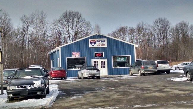
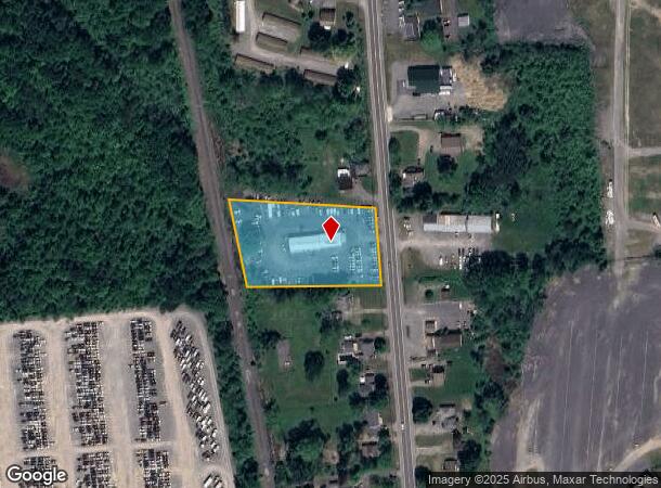
Property Record
99 Us Route 11, Central Square, NY 13036
NEARBY LISTINGS FOR SALE OR LEASE
Property Detail
99 Us Route 11
353289-293-018-0001-007-002-0000
Case Subdivision
Storesoffices
Oswego
X
New York
36067C0082F
7.020
2025
1.84 AC
2024
Oswego County
020707
Syracuse
3,328 SF
Syracuse, NY
DEMOGRAPHICS near 99 Us Route 11
1 Mile
3 Mile
5 Mile
2024 Total Population
1,562
8,586
19,952
2029 Population
1,547
8,427
19,601
Pop Growth 2024-2029
(0.96%)
(1.85%)
(1.76%)
Average Age
44
43
43
2024 Total Households
659
3,612
8,140
HH Growth 2024-2029
(1.21%)
(2.05%)
(1.90%)
Median Household Inc
$83,216
$75,853
$83,009
Avg Household Size
2.30
2.30
2.40
2024 Avg HH Vehicles
2.00
2.00
2.00
Median Home Value
$192,049
$199,249
$189,629
Median Year Built
1975
1979
1981
Nearby Places
- Restaurants
- Banks
- Shops
- Fitness
- Groceries
PUBLIC TRANSPORTATION
AIRPORT
Syracuse Hancock International
DRIVE
WALK
Distance
Syracuse Hancock International
17 min
12.0 mi
Freight Ports
Albany, NY Port
DRIVE
WALK
Distance
Albany, NY Port
182 min
152.4 mi
SALE & LEASE HISTORY
LISTING DATE
SALE/LEASE

Sep 24, 2016
For Sale
Nearby Properties
Address
Land Use
TOTAL SIZE
Lot Size
Zoning
Address
Land Use
TOTAL SIZE
Lot Size
Zoning
97,288 SF
62.96 AC
05
Address
Land Use
TOTAL SIZE
Lot Size
Zoning
150,670 SF
31.81 AC
CR
Address
Land Use
TOTAL SIZE
Lot Size
Zoning
1,568 SF
330.36 AC
Address
Land Use
TOTAL SIZE
Lot Size
Zoning
39,128 SF
17.22 AC
Address
Land Use
TOTAL SIZE
Lot Size
Zoning
660 SF
9.75 AC
WH
Address
Land Use
TOTAL SIZE
Lot Size
Zoning
51,587 SF
10.37 AC
Address
Land Use
TOTAL SIZE
Lot Size
Zoning
50,512 SF
4.50 AC
05 - COMME
Address
Land Use
TOTAL SIZE
Lot Size
Zoning
39,591 SF
7.39 AC
Address
Land Use
TOTAL SIZE
Lot Size
Zoning
12,978 SF
3.71 AC
PUD-R
Address
Land Use
TOTAL SIZE
Lot Size
Zoning
56,215 SF
7.31 AC
Address
Land Use
TOTAL SIZE
Lot Size
Zoning
11.96 AC
Address
Land Use
TOTAL SIZE
Lot Size
Zoning
32,640 SF
4.48 AC
Address
Land Use
TOTAL SIZE
Lot Size
Zoning
7,500 SF
21.82 AC
CI
Address
Land Use
TOTAL SIZE
Lot Size
Zoning
23,168 SF
3.19 AC
05 - COMME
Address
Land Use
TOTAL SIZE
Lot Size
Zoning
4,416 SF
5.37 AC
03 - MULTI
Address
Land Use
TOTAL SIZE
Lot Size
Zoning
46,400 SF
4.39 AC
W
Address
Land Use
TOTAL SIZE
Lot Size
Zoning
1,900 SF
144.90 AC
01 - NOT Z
Address
Land Use
TOTAL SIZE
Lot Size
Zoning
13,576 SF
1.98 AC
Address
Land Use
TOTAL SIZE
Lot Size
Zoning
13,576 SF
1.98 AC
Address
Land Use
TOTAL SIZE
Lot Size
Zoning
10,162 SF
21.86 AC
02 - SINGL
Address
Land Use
TOTAL SIZE
Lot Size
Zoning
25,420 SF
3.42 AC
02 - SINGL
Address
Land Use
TOTAL SIZE
Lot Size
Zoning
3,200 SF
6.39 AC
CI
Address
Land Use
TOTAL SIZE
Lot Size
Zoning
19,028 SF
5.55 AC
Address
Land Use
TOTAL SIZE
Lot Size
Zoning
19,127 SF
1.98 AC
Address
Land Use
TOTAL SIZE
Lot Size
Zoning
1,360 SF
28.10 AC
Address
Land Use
TOTAL SIZE
Lot Size
Zoning
39,875 SF
2.83 AC
01 - NOT Z
Address
Land Use
TOTAL SIZE
Lot Size
Zoning
6,440 SF
2.53 AC
Address
Land Use
TOTAL SIZE
Lot Size
Zoning
14,034 SF
11.96 AC
Address
Land Use
TOTAL SIZE
Lot Size
Zoning
12,978 SF
1.76 AC
PUD-R
Address
Land Use
TOTAL SIZE
Lot Size
Zoning
8,068 SF
3.33 AC
The World's #1 Commercial Real Estate Marketplace
Connect with us
© 2025 CoStar Group
The information above has been obtained from sources believed reliable. While we do not doubt its accuracy we have not verified it and make no guarantee, warranty or representation about it. It is your responsibility to independently confirm its accuracy and completeness. Any projections, opinions, assumptions, or estimates used are for example only and do not represent the current or future performance of the property. The value of this transaction to you depends on tax and other factors which should be evaluated by your tax, financial, and legal advisors. You and your advisors should conduct a careful, independent investigation of the property to determine to your satisfaction the suitability of the property for your needs.