Property Record
990 Ely Rd N, Petaluma, CA 94954
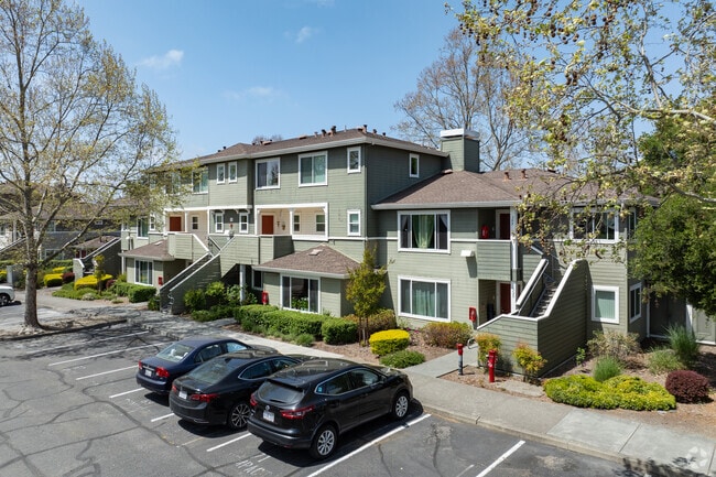

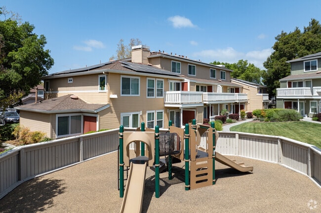
Property Detail
990 Ely Rd N
137-280-017
94 FM PT 137-060-089 CORONA CRESCENT, LOT 17
Apartment
Sonoma
CITYPE
California
B and X Area of moderate flood hazard, usually the area between the limits of the 100-year and 500-year floods.
17
2025
4.14 AC
2025
East Petaluma
150610
North Bay/Santa Rosa
81,859 SF
Santa Rosa-Petaluma, CA
NEARBY LISTINGS FOR SALE OR LEASE
DEMOGRAPHICS near 990 Ely Rd N
1 mile
3 mile
5 mile
2025 Total Population
10,639
50,139
84,726
2030 Population
10,552
49,873
84,307
Pop Growth 2025-2030
(0.82%)
(0.53%)
(0.49%)
Average Age
44
44
43
2025 Total Households
4,111
19,684
31,760
HH Growth 2025-2030
(0.78%)
(0.51%)
(0.52%)
Median Household Inc
$124,800
$108,240
$111,567
Avg Household Size
2.60
2.50
2.50
2025 Avg HH Vehicles
2.00
2.00
2.00
Median Home Value
$747,982
$810,113
$841,479
Median Year Built
1991
1978
1981
Nearby Places
Map Layers
Map Styles
 Street
 Aerial
Layers
 Traffic
 Biking
Places
Listings with unknown addresses are not visible on the map
- Restaurants
- Banks
- Shops
- Fitness
- Groceries
PUBLIC TRANSPORTATION
COMMUTER RAIL
Drive
Walk
Distance
3 min
16 min
0.8 mi
Drive
Walk
Distance
7 min
3.6 mi
AIRPORT
Charles M Schulz - Sonoma County
Drive
Walk
Distance
Charles M Schulz - Sonoma County
31 min
21.4 mi
Freight Ports
Port of Richmond
Drive
Walk
Distance
Port of Richmond
50 min
35.7 mi
Nearby Properties
Address
Land Use
TOTAL SIZE
Lot Size
Zoning
Address
Land Use
TOTAL SIZE
Lot Size
Zoning
226,772 SF
8.05 AC
Address
Land Use
TOTAL SIZE
Lot Size
Zoning
38,083 SF
16.14 AC
Address
Land Use
TOTAL SIZE
Lot Size
Zoning
3,967 SF
5.03 AC
CITYPE
Address
Land Use
TOTAL SIZE
Lot Size
Zoning
150,025 SF
1.48 AC
Address
Land Use
TOTAL SIZE
Lot Size
Zoning
165,541 SF
12.61 AC
Address
Land Use
TOTAL SIZE
Lot Size
Zoning
63,000 SF
5.40 AC
CITYPE
Address
Land Use
TOTAL SIZE
Lot Size
Zoning
137,270 SF
10.04 AC
Address
Land Use
TOTAL SIZE
Lot Size
Zoning
35,408 SF
2.66 AC
Address
Land Use
TOTAL SIZE
Lot Size
Zoning
82,704 SF
14.63 AC
CITYPE
Address
Land Use
TOTAL SIZE
Lot Size
Zoning
59,351 SF
14.53 AC
Address
Land Use
TOTAL SIZE
Lot Size
Zoning
83,653 SF
1.18 AC
Address
Land Use
TOTAL SIZE
Lot Size
Zoning
23,979 SF
5.85 AC
Address
Land Use
TOTAL SIZE
Lot Size
Zoning
63,959 SF
7.13 AC
Address
Land Use
TOTAL SIZE
Lot Size
Zoning
195,837 SF
16.32 AC
PCD
Address
Land Use
TOTAL SIZE
Lot Size
Zoning
85,582 SF
2.61 AC
CITYPE
Address
Land Use
TOTAL SIZE
Lot Size
Zoning
83,109 SF
9.56 AC
Address
Land Use
TOTAL SIZE
Lot Size
Zoning
5,640 SF
7.31 AC
CITYPE
Address
Land Use
TOTAL SIZE
Lot Size
Zoning
20,728 SF
10.36 AC
ML
Address
Land Use
TOTAL SIZE
Lot Size
Zoning
73,279 SF
0.96 AC
MG
Address
Land Use
TOTAL SIZE
Lot Size
Zoning
70,110 SF
1.11 AC
CITYPE
Address
Land Use
TOTAL SIZE
Lot Size
Zoning
93,700 SF
6.02 AC
ML
Address
Land Use
TOTAL SIZE
Lot Size
Zoning
4,608 SF
1.43 AC
CITYPE
Address
Land Use
TOTAL SIZE
Lot Size
Zoning
81,975 SF
5 AC
Address
Land Use
TOTAL SIZE
Lot Size
Zoning
88,482 SF
7.29 AC
Address
Land Use
TOTAL SIZE
Lot Size
Zoning
64,568 SF
0.87 AC
Address
Land Use
TOTAL SIZE
Lot Size
Zoning
83,880 SF
5 AC
ML
Address
Land Use
TOTAL SIZE
Lot Size
Zoning
49,549 SF
4.02 AC
CITYPE
Address
Land Use
TOTAL SIZE
Lot Size
Zoning
43,050 SF
1.38 AC
Address
Land Use
TOTAL SIZE
Lot Size
Zoning
7.52 AC
The World's #1 Commercial Real Estate Marketplace
Connect with us
© 2026 CoStar Group
The information above has been obtained from sources believed reliable. While we do not doubt its accuracy we have not verified it and make no guarantee, warranty or representation about it. It is your responsibility to independently confirm its accuracy and completeness. Any projections, opinions, assumptions, or estimates used are for example only and do not represent the current or future performance of the property. The value of this transaction to you depends on tax and other factors which should be evaluated by your tax, financial, and legal advisors. You and your advisors should conduct a careful, independent investigation of the property to determine to your satisfaction the suitability of the property for your needs.