Property Record
990 Ribaut Rd, Beaufort, SC 29902


Save to a Folder
{{folder.Name}}
{{folder.ListingIds.length}} Properties
{{folder.ListingIds.length}} Property
Create a New Folder
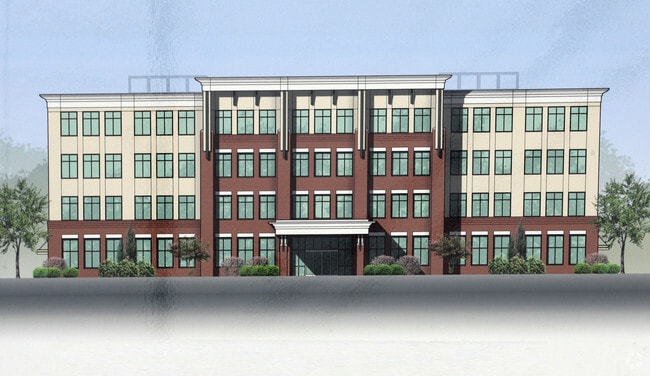
Property Detail
990 Ribaut Rd
R120-005-000-0175-0000
LOTS 10 12 POR LOT 11 ROYAL GARDENS TOT AC INC 0.13 AC CRITICAL AREA FKA LOT 12
Medicalbuilding
Beaufort
6611
South Carolina
2025
10-12
2025
4.76 AC
000700
Other Market Areas
87,456 SF
Hilton Head Island-Bluffton-Port Royal, SC
NEARBY LISTINGS FOR SALE OR LEASE
DEMOGRAPHICS near 990 Ribaut Rd
1 mile
3 mile
5 mile
2025 Total Population
3,235
21,544
46,730
2030 Population
3,368
22,493
48,687
Pop Growth 2025-2030
+ 4.11%
+ 4.40%
+ 4.19%
Average Age
44
42
39
2025 Total Households
1,446
9,293
17,257
HH Growth 2025-2030
+ 4.22%
+ 4.57%
+ 4.56%
Median Household Inc
$87,998
$68,353
$68,860
Avg Household Size
2.10
2.20
2.40
2025 Avg HH Vehicles
2.00
2.00
2.00
Median Home Value
$357,024
$366,098
$350,046
Median Year Built
1983
1987
1993
Nearby Places
Map Layers
Map Styles
 Street
 Aerial
Layers
 Traffic
 Biking
Places
Listings with unknown addresses are not visible on the map
- Restaurants
- Banks
- Shops
- Fitness
- Groceries
PUBLIC TRANSPORTATION
AIRPORT
Hilton Head
Drive
Walk
Distance
Hilton Head
54 min
39.3 mi
Freight Ports
Georgia Ports - Savannah
Drive
Walk
Distance
Georgia Ports - Savannah
63 min
48.7 mi
Nearby Properties
Address
Land Use
TOTAL SIZE
Lot Size
Zoning
Address
Land Use
TOTAL SIZE
Lot Size
Zoning
361,033 SF
21.89 AC
6611
Address
Land Use
TOTAL SIZE
Lot Size
Zoning
308,567 SF
26.58 AC
Address
Land Use
TOTAL SIZE
Lot Size
Zoning
252,178 SF
19.36 AC
6601
Address
Land Use
TOTAL SIZE
Lot Size
Zoning
173,303 SF
16.12 AC
Address
Land Use
TOTAL SIZE
Lot Size
Zoning
240,395 SF
4.45 AC
6601
Address
Land Use
TOTAL SIZE
Lot Size
Zoning
148,706 SF
16.27 AC
6612
Address
Land Use
TOTAL SIZE
Lot Size
Zoning
134,196 SF
9.67 AC
6101
Address
Land Use
TOTAL SIZE
Lot Size
Zoning
56,139 SF
6.97 AC
6611
Address
Land Use
TOTAL SIZE
Lot Size
Zoning
101,304 SF
6.47 AC
6611
Address
Land Use
TOTAL SIZE
Lot Size
Zoning
147,556 SF
22.54 AC
6611
Address
Land Use
TOTAL SIZE
Lot Size
Zoning
78,168 SF
11 AC
Address
Land Use
TOTAL SIZE
Lot Size
Zoning
75,973 SF
2.05 AC
6611
Address
Land Use
TOTAL SIZE
Lot Size
Zoning
214,795 SF
24.94 AC
6611
Address
Land Use
TOTAL SIZE
Lot Size
Zoning
56,043 SF
4.18 AC
6601
Address
Land Use
TOTAL SIZE
Lot Size
Zoning
144,226 SF
41.30 AC
6611
Address
Land Use
TOTAL SIZE
Lot Size
Zoning
142,753 SF
47.79 AC
6611
Address
Land Use
TOTAL SIZE
Lot Size
Zoning
116,067 SF
27 AC
6611
Address
Land Use
TOTAL SIZE
Lot Size
Zoning
18,312 SF
47.49 AC
6611
Address
Land Use
TOTAL SIZE
Lot Size
Zoning
50,800 SF
4.03 AC
6611
Address
Land Use
TOTAL SIZE
Lot Size
Zoning
25,475 SF
4.10 AC
6611
Address
Land Use
TOTAL SIZE
Lot Size
Zoning
60,814 SF
3 AC
Address
Land Use
TOTAL SIZE
Lot Size
Zoning
87,884 SF
4.16 AC
6611
Address
Land Use
TOTAL SIZE
Lot Size
Zoning
76,552 SF
2.42 AC
6611
Address
Land Use
TOTAL SIZE
Lot Size
Zoning
75,342 SF
10.60 AC
6611
Address
Land Use
TOTAL SIZE
Lot Size
Zoning
92,125 SF
10.14 AC
6611
Address
Land Use
TOTAL SIZE
Lot Size
Zoning
134,446 SF
19.90 AC
6611
Address
Land Use
TOTAL SIZE
Lot Size
Zoning
3,304 SF
7.50 AC
6611
Address
Land Use
TOTAL SIZE
Lot Size
Zoning
70,055 SF
10.50 AC
6111
Address
Land Use
TOTAL SIZE
Lot Size
Zoning
57,117 SF
2.03 AC
The World's #1 Commercial Real Estate Marketplace
Connect with us
© 2026 CoStar Group
The information above has been obtained from sources believed reliable. While we do not doubt its accuracy we have not verified it and make no guarantee, warranty or representation about it. It is your responsibility to independently confirm its accuracy and completeness. Any projections, opinions, assumptions, or estimates used are for example only and do not represent the current or future performance of the property. The value of this transaction to you depends on tax and other factors which should be evaluated by your tax, financial, and legal advisors. You and your advisors should conduct a careful, independent investigation of the property to determine to your satisfaction the suitability of the property for your needs.