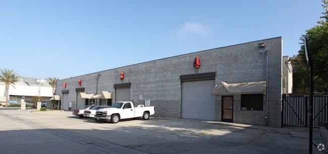
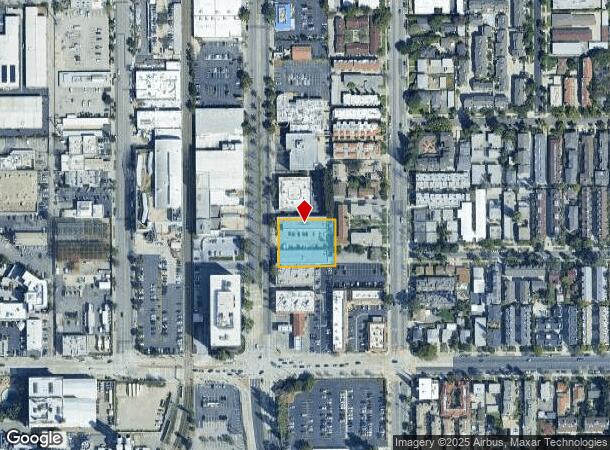
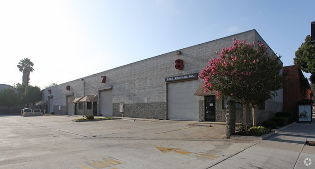
Property Record
990 S Arroyo Pky, Pasadena, CA 91105

Current Lease Availabilities
NEARBY LISTINGS FOR SALE OR LEASE
Property Detail
990 S Arroyo Pky
Los Angeles-Long Beach-Glendale, CA
South Marengo Boulevard Tract
5720-017-035
*TR=SOUTH MARENGO BLVD TRACT*LOTS 14, 15 AND LOT 16
Warehouse
Los Angeles
X
California
06037C1375F
14
2024
0.64 AC
2025
Upper San Gabriel Valley
463700
Los Angeles
13,576 SF
DEMOGRAPHICS near 990 S Arroyo Pky
1 Mile
3 Mile
5 Mile
2024 Total Population
25,786
223,080
571,726
2029 Population
25,137
216,644
553,301
Pop Growth 2024-2029
(2.52%)
(2.89%)
(3.22%)
Average Age
42
41
42
2024 Total Households
12,426
89,044
207,578
HH Growth 2024-2029
(2.81%)
(3.06%)
(3.43%)
Median Household Inc
$109,782
$93,898
$90,206
Avg Household Size
2.00
2.40
2.60
2024 Avg HH Vehicles
2.00
2.00
2.00
Median Home Value
$1,016,710
$966,941
$896,989
Median Year Built
1968
1959
1956
Nearby Places
- Restaurants
- Banks
- Shops
- Fitness
- Groceries
PUBLIC TRANSPORTATION
TRANSIT/SUBWAY
Fillmore Station (Gold Line - Los Angeles County Metropolitan Transportation Authority (Metro))
DRIVE
WALK
Distance
Fillmore Station (Gold Line - Los Angeles County Metropolitan Transportation Authority (Metro))
2 min
8 min
0.4 mi
Del Mar Station (Gold Line - Los Angeles County Metropolitan Transportation Authority (Metro))
DRIVE
WALK
Distance
Del Mar Station (Gold Line - Los Angeles County Metropolitan Transportation Authority (Metro))
4 min
19 min
1.0 mi
COMMUTER RAIL
DRIVE
WALK
Distance
14 min
8.7 mi
Glendale (Antelope Valley Line - Southern California Regional Rail Authority (Metrolink), Ventura County Line - Southern California Regional Rail Authority (Metrolink))
DRIVE
WALK
Distance
Glendale (Antelope Valley Line - Southern California Regional Rail Authority (Metrolink), Ventura County Line - Southern California Regional Rail Authority (Metrolink))
15 min
10.0 mi
AIRPORT
Bob Hope
DRIVE
WALK
Distance
Bob Hope
25 min
17.5 mi
Los Angeles International
DRIVE
WALK
Distance
Los Angeles International
37 min
23.8 mi
Long Beach (Daugherty Field)
DRIVE
WALK
Distance
Long Beach (Daugherty Field)
39 min
25.0 mi
Freight Ports
Port of Long Beach
DRIVE
WALK
Distance
Port of Long Beach
41 min
27.8 mi
Nearby Properties
Address
Land Use
TOTAL SIZE
Lot Size
Zoning
Address
Land Use
TOTAL SIZE
Lot Size
Zoning
874,871 SF
25.01 AC
PSC*
Address
Land Use
TOTAL SIZE
Lot Size
Zoning
327,804 SF
17.76 AC
PSR*
Address
Land Use
TOTAL SIZE
Lot Size
Zoning
643,699 SF
9.73 AC
PSC-
Address
Land Use
TOTAL SIZE
Lot Size
Zoning
1,067,590 SF
7.22 AC
PSC-
Address
Land Use
TOTAL SIZE
Lot Size
Zoning
346,537 SF
3.33 AC
PSC-
Address
Land Use
TOTAL SIZE
Lot Size
Zoning
523,298 SF
5.74 AC
PSC-
Address
Land Use
TOTAL SIZE
Lot Size
Zoning
11,590 SF
14.43 AC
PSC*
Address
Land Use
TOTAL SIZE
Lot Size
Zoning
262,988 SF
1.42 AC
PSR*
Address
Land Use
TOTAL SIZE
Lot Size
Zoning
91,229 SF
206.59 AC
SOH
Address
Land Use
TOTAL SIZE
Lot Size
Zoning
278,741 SF
1.21 AC
PSC*
Address
Land Use
TOTAL SIZE
Lot Size
Zoning
407,027 SF
3.91 AC
PSC-
Address
Land Use
TOTAL SIZE
Lot Size
Zoning
385,765 SF
4.41 AC
PSC-
Address
Land Use
TOTAL SIZE
Lot Size
Zoning
291,667 SF
0.83 AC
PSC-
Address
Land Use
TOTAL SIZE
Lot Size
Zoning
255,411 SF
0.81 AC
PSC-
Address
Land Use
TOTAL SIZE
Lot Size
Zoning
231,187 SF
1.47 AC
PSC-
Address
Land Use
TOTAL SIZE
Lot Size
Zoning
516,474 SF
4.37 AC
ALCBD/DRD*
Address
Land Use
TOTAL SIZE
Lot Size
Zoning
192,792 SF
14.52 AC
PSR
Address
Land Use
TOTAL SIZE
Lot Size
Zoning
588,972 SF
2.59 AC
PSC-
Address
Land Use
TOTAL SIZE
Lot Size
Zoning
372,451 SF
3.24 AC
PSC*
Address
Land Use
TOTAL SIZE
Lot Size
Zoning
236,801 SF
1.67 AC
PSC-
Address
Land Use
TOTAL SIZE
Lot Size
Zoning
246,000 SF
5.67 AC
PSC-
Address
Land Use
TOTAL SIZE
Lot Size
Zoning
749,874 SF
4.74 AC
PSC-
Address
Land Use
TOTAL SIZE
Lot Size
Zoning
233,424 SF
1.67 AC
PSC-
Address
Land Use
TOTAL SIZE
Lot Size
Zoning
255,343 SF
0.80 AC
PSC-
Address
Land Use
TOTAL SIZE
Lot Size
Zoning
266,947 SF
10.91 AC
PSC2
Address
Land Use
TOTAL SIZE
Lot Size
Zoning
91,145 SF
1.21 AC
PSC-
Address
Land Use
TOTAL SIZE
Lot Size
Zoning
100,653 SF
1.41 AC
PSC-
Address
Land Use
TOTAL SIZE
Lot Size
Zoning
139,416 SF
10.27 AC
PSR*
Address
Land Use
TOTAL SIZE
Lot Size
Zoning
220,402 SF
1.35 AC
PSC-
The World's #1 Commercial Real Estate Marketplace
Connect with us
© 2025 CoStar Group
The information above has been obtained from sources believed reliable. While we do not doubt its accuracy we have not verified it and make no guarantee, warranty or representation about it. It is your responsibility to independently confirm its accuracy and completeness. Any projections, opinions, assumptions, or estimates used are for example only and do not represent the current or future performance of the property. The value of this transaction to you depends on tax and other factors which should be evaluated by your tax, financial, and legal advisors. You and your advisors should conduct a careful, independent investigation of the property to determine to your satisfaction the suitability of the property for your needs.