Property Record
990 State Route 149, Queensbury, NY 12804
NEARBY LISTINGS FOR SALE OR LEASE
-
-
View all Queensbury listings for sale on LoopNet.com
Property Detail
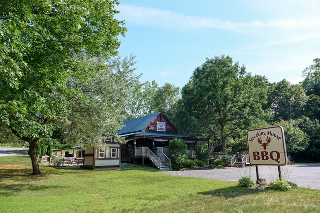
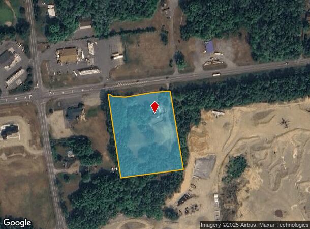
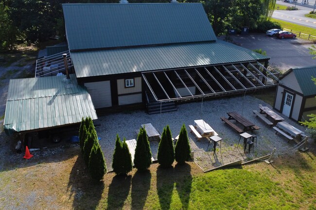
990 State Route 149
Glens Falls, NY
FOUNDATION (PARTIAL) 350.07'RF 52.-2-1.34
523400-279-000-0001-008-000-0000
Warren
Restaurantdrivein
New York
2025
8.000
2024
3.65 AC
070701
Warren County
671 SF
Albany/Schenectady/Troy
DEMOGRAPHICS near 990 State Route 149
1 Mile
3 Mile
5 Mile
2024 Total Population
416
4,545
14,269
2029 Population
430
4,649
14,476
Pop Growth 2024-2029
+ 3.37%
+ 2.29%
+ 1.45%
Average Age
45
46
47
2024 Total Households
167
1,908
6,234
HH Growth 2024-2029
+ 2.99%
+ 2.20%
+ 1.33%
Median Household Inc
$81,410
$76,411
$79,353
Avg Household Size
2.30
2.20
2.20
2024 Avg HH Vehicles
2.00
2.00
2.00
Median Home Value
$275,714
$268,321
$278,966
Median Year Built
1977
1983
1985
Nearby Places
- Restaurants
- Banks
- Shops
- Fitness
- Groceries
SALE & LEASE HISTORY
LISTING DATE
SALE/LEASE

Jul 30, 2024
For Sale
Nearby Properties
Address
Land Use
TOTAL SIZE
Lot Size
Zoning
Address
Land Use
TOTAL SIZE
Lot Size
Zoning
3,990 SF
157.26 AC
01 - NOT Z
Address
Land Use
TOTAL SIZE
Lot Size
Zoning
696 SF
55.11 AC
MDR
Address
Land Use
TOTAL SIZE
Lot Size
Zoning
10,450 SF
8 AC
1
Address
Land Use
TOTAL SIZE
Lot Size
Zoning
808 SF
19.55 AC
MDR
Address
Land Use
TOTAL SIZE
Lot Size
Zoning
14,400 SF
196.26 AC
PUD
Address
Land Use
TOTAL SIZE
Lot Size
Zoning
14,982 SF
4.32 AC
RR-3A
Address
Land Use
TOTAL SIZE
Lot Size
Zoning
1,303.63 AC
NYS
Address
Land Use
TOTAL SIZE
Lot Size
Zoning
6,208 SF
209.76 AC
RR-5A
Address
Land Use
TOTAL SIZE
Lot Size
Zoning
218.80 AC
01 - NOT Z
Address
Land Use
TOTAL SIZE
Lot Size
Zoning
4,595 SF
79.98 AC
MDR
Address
Land Use
TOTAL SIZE
Lot Size
Zoning
5,490 SF
3.63 AC
NC
Address
Land Use
TOTAL SIZE
Lot Size
Zoning
71.70 AC
1
Address
Land Use
TOTAL SIZE
Lot Size
Zoning
3,672 SF
1.73 AC
NC
Address
Land Use
TOTAL SIZE
Lot Size
Zoning
57.26 AC
RR-5A
Address
Land Use
TOTAL SIZE
Lot Size
Zoning
13,145 SF
5.50 AC
MDR
Address
Land Use
TOTAL SIZE
Lot Size
Zoning
3,168 SF
24.11 AC
SPLIT
Address
Land Use
TOTAL SIZE
Lot Size
Zoning
4,256 SF
18.05 AC
MDR
Address
Land Use
TOTAL SIZE
Lot Size
Zoning
2,176 SF
99.23 AC
LC-10A
Address
Land Use
TOTAL SIZE
Lot Size
Zoning
6,000 SF
2.11 AC
MDR
Address
Land Use
TOTAL SIZE
Lot Size
Zoning
1,850 SF
2.68 AC
RR-5A
Address
Land Use
TOTAL SIZE
Lot Size
Zoning
11,388 SF
2.10 AC
RR-3A
Address
Land Use
TOTAL SIZE
Lot Size
Zoning
1,040 SF
22.47 AC
01 - NOT Z
Address
Land Use
TOTAL SIZE
Lot Size
Zoning
1,671 SF
187.28 AC
PUD
Address
Land Use
TOTAL SIZE
Lot Size
Zoning
4,256 SF
13.39 AC
MDR
Address
Land Use
TOTAL SIZE
Lot Size
Zoning
9,212 SF
1.60 AC
NC
Address
Land Use
TOTAL SIZE
Lot Size
Zoning
54.24 AC
CLI
Address
Land Use
TOTAL SIZE
Lot Size
Zoning
5,880 SF
19.90 AC
RR-3A
Address
Land Use
TOTAL SIZE
Lot Size
Zoning
46.34 AC
LC-10A
Address
Land Use
TOTAL SIZE
Lot Size
Zoning
30.90 AC
01 - NOT Z
Address
Land Use
TOTAL SIZE
Lot Size
Zoning
3,972 SF
9.93 AC
SPLIT
The World's #1 Commercial Real Estate Marketplace
Connect with us
© 2025 CoStar Group
The information above has been obtained from sources believed reliable. While we do not doubt its accuracy we have not verified it and make no guarantee, warranty or representation about it. It is your responsibility to independently confirm its accuracy and completeness. Any projections, opinions, assumptions, or estimates used are for example only and do not represent the current or future performance of the property. The value of this transaction to you depends on tax and other factors which should be evaluated by your tax, financial, and legal advisors. You and your advisors should conduct a careful, independent investigation of the property to determine to your satisfaction the suitability of the property for your needs.