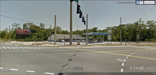
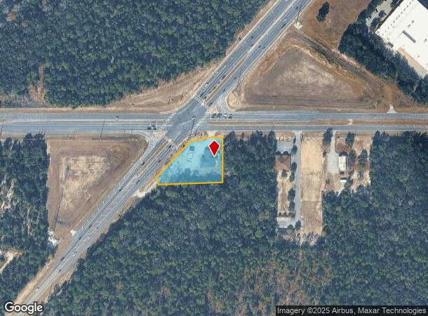
Property Record
9900 Sw Highway 200, Ocala, FL 34481
NEARBY LISTINGS FOR SALE OR LEASE
Property Detail
9900 Sw Highway 200
35341-001-02
Sportsmans Park Subdivision
Regionalshoppingcenterormallwithanchorstore
SEC 35 TWP 16 RGE 20 COM AT THE SW COR OF N 3/4 TH N 88-15-59 E ALONG SAID S BDY OF SAID N 3/4 224.88 FT TO THE SELY ROW OF SR 200 TH N 40-29-10 E ALONG SAID SELY ROW 490.83 FT TO THE POB TH CONT N 40-29-10 E ALONG SAID SELY ROW 279.17 FT TO THE S RO
X
Marion
12083C0691E
Florida
2025
1.18 AC
2025
Outlying Marion County
001005
Ocala
6,895 SF
Ocala, FL
DEMOGRAPHICS near 9900 Sw Highway 200
1 Mile
3 Mile
5 Mile
2024 Total Population
333
19,680
45,651
2029 Population
372
22,308
52,008
Pop Growth 2024-2029
+ 11.71%
+ 13.35%
+ 13.93%
Average Age
70
64
59
2024 Total Households
194
10,639
22,393
HH Growth 2024-2029
+ 11.86%
+ 13.17%
+ 13.70%
Median Household Inc
$47,000
$53,702
$56,358
Avg Household Size
1.60
1.80
2.00
2024 Avg HH Vehicles
1.00
1.00
2.00
Median Home Value
$163,414
$164,170
$189,622
Median Year Built
1991
1994
1998
Nearby Places
Map Layers
Map Styles
 Street
 Aerial
- Restaurants
- Banks
- Shops
- Fitness
- Groceries
Nearby Properties
Address
Land Use
TOTAL SIZE
Lot Size
Zoning
Address
Land Use
TOTAL SIZE
Lot Size
Zoning
96,094 SF
13.66 AC
B2
Address
Land Use
TOTAL SIZE
Lot Size
Zoning
103,410 SF
27.04 AC
PUD
Address
Land Use
TOTAL SIZE
Lot Size
Zoning
74,928 SF
7.80 AC
PUD
Address
Land Use
TOTAL SIZE
Lot Size
Zoning
210,937 SF
27.08 AC
B4
Address
Land Use
TOTAL SIZE
Lot Size
Zoning
3,474.32 AC
A1
Address
Land Use
TOTAL SIZE
Lot Size
Zoning
28,813 SF
70.30 AC
B4
Address
Land Use
TOTAL SIZE
Lot Size
Zoning
18,035 SF
3.33 AC
B2
Address
Land Use
TOTAL SIZE
Lot Size
Zoning
43,619 SF
6.04 AC
R3
Address
Land Use
TOTAL SIZE
Lot Size
Zoning
101,312 SF
5,201.15 AC
A1
Address
Land Use
TOTAL SIZE
Lot Size
Zoning
98,205 SF
13.41 AC
B2
Address
Land Use
TOTAL SIZE
Lot Size
Zoning
88,777 SF
10.50 AC
B4
Address
Land Use
TOTAL SIZE
Lot Size
Zoning
69,278 SF
7.52 AC
B4
Address
Land Use
TOTAL SIZE
Lot Size
Zoning
68,180 SF
5.40 AC
B5
Address
Land Use
TOTAL SIZE
Lot Size
Zoning
82,904 SF
10.51 AC
B2
Address
Land Use
TOTAL SIZE
Lot Size
Zoning
16,729 SF
5 AC
B4
Address
Land Use
TOTAL SIZE
Lot Size
Zoning
27,563 SF
3.03 AC
B4
Address
Land Use
TOTAL SIZE
Lot Size
Zoning
47,378 SF
23.26 AC
A1
Address
Land Use
TOTAL SIZE
Lot Size
Zoning
286.80 AC
PUD
Address
Land Use
TOTAL SIZE
Lot Size
Zoning
16,214 SF
4.91 AC
B2
Address
Land Use
TOTAL SIZE
Lot Size
Zoning
37,213 SF
14.54 AC
A1
Address
Land Use
TOTAL SIZE
Lot Size
Zoning
27,862 SF
17.04 AC
A1
Address
Land Use
TOTAL SIZE
Lot Size
Zoning
41,642 SF
5.47 AC
B4
Address
Land Use
TOTAL SIZE
Lot Size
Zoning
20,288 SF
7.20 AC
B2
Address
Land Use
TOTAL SIZE
Lot Size
Zoning
17,428 SF
2.01 AC
B4
Address
Land Use
TOTAL SIZE
Lot Size
Zoning
45,364 SF
6.69 AC
B2
Address
Land Use
TOTAL SIZE
Lot Size
Zoning
955 AC
A1
Address
Land Use
TOTAL SIZE
Lot Size
Zoning
16,308 SF
1.74 AC
B2
Address
Land Use
TOTAL SIZE
Lot Size
Zoning
30,847 SF
6 AC
A1
Address
Land Use
TOTAL SIZE
Lot Size
Zoning
16,954 SF
1.68 AC
B4
Address
Land Use
TOTAL SIZE
Lot Size
Zoning
13,089 SF
1.72 AC
B2
The World's #1 Commercial Real Estate Marketplace
Connect with us
© 2026 CoStar Group
The information above has been obtained from sources believed reliable. While we do not doubt its accuracy we have not verified it and make no guarantee, warranty or representation about it. It is your responsibility to independently confirm its accuracy and completeness. Any projections, opinions, assumptions, or estimates used are for example only and do not represent the current or future performance of the property. The value of this transaction to you depends on tax and other factors which should be evaluated by your tax, financial, and legal advisors. You and your advisors should conduct a careful, independent investigation of the property to determine to your satisfaction the suitability of the property for your needs.