Property Record
9900 W Colfax Ave, Lakewood, CO 80215

NEARBY LISTINGS FOR SALE OR LEASE
Property Detail
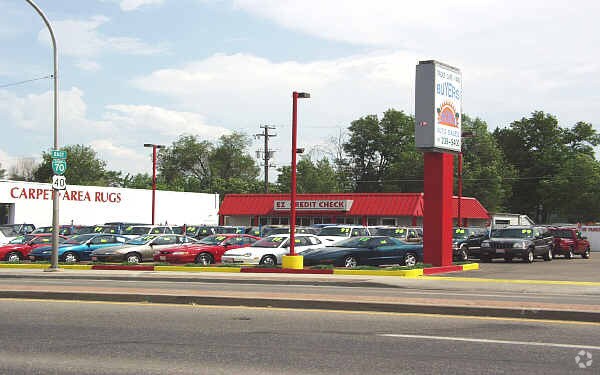
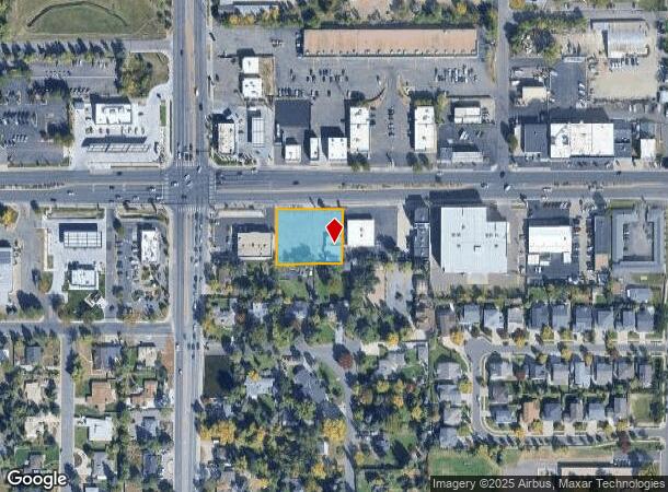
9900 W Colfax Ave
49-032-00-069
Acreage
Commercialnec
SECTION 03 TOWNSHIP 04 RANGE 69 QTR NW SIZE: 26659 VALUE: .612 KEY=042
X
Jefferson
08059C0301F
Colorado
2023
0.61 AC
2024
West
011101
Denver
2,384 SF
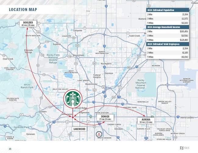
Denver-Aurora-Lakewood, CO
DEMOGRAPHICS near 9900 W Colfax Ave
1 Mile
3 Mile
5 Mile
2024 Total Population
13,319
112,319
317,549
2029 Population
13,418
111,909
317,199
Pop Growth 2024-2029
+ 0.74%
(0.37%)
(0.11%)
Average Age
41
41
40
2024 Total Households
6,067
49,737
135,760
HH Growth 2024-2029
+ 0.71%
(0.42%)
(0.12%)
Median Household Inc
$65,443
$73,341
$79,141
Avg Household Size
2.10
2.20
2.20
2024 Avg HH Vehicles
2.00
2.00
2.00
Median Home Value
$545,686
$564,141
$524,158
Median Year Built
1972
1971
1970
Nearby Places
- Restaurants
- Banks
- Shops
- Fitness
- Groceries
PUBLIC TRANSPORTATION
TRANSIT/SUBWAY
Garrison (W Line - Denver Regional Transportation District Light Rail (TheRide))
DRIVE
WALK
Distance
Garrison (W Line - Denver Regional Transportation District Light Rail (TheRide))
2 min
13 min
0.7 mi
Oak (W Line - Denver Regional Transportation District Light Rail (TheRide))
DRIVE
WALK
Distance
Oak (W Line - Denver Regional Transportation District Light Rail (TheRide))
2 min
15 min
0.8 mi
COMMUTER RAIL
Arvada Ridge Station Track 1 (Union Station to Wheat Ridge Ward Station - Regional Transportation District)
DRIVE
WALK
Distance
Arvada Ridge Station Track 1 (Union Station to Wheat Ridge Ward Station - Regional Transportation District)
9 min
4.4 mi
Wheat Ridge - Ward Station Track 1 (Union Station to Wheat Ridge Ward Station - Regional Transportation District)
DRIVE
WALK
Distance
Wheat Ridge - Ward Station Track 1 (Union Station to Wheat Ridge Ward Station - Regional Transportation District)
11 min
5.0 mi
AIRPORT
Denver International
DRIVE
WALK
Distance
Denver International
42 min
32.0 mi
Freight Ports
Tulsa Port Of Catoosa
DRIVE
WALK
Distance
Tulsa Port Of Catoosa
739 min
717.5 mi
SALE & LEASE HISTORY
LISTING DATE
SALE/LEASE

Sep 29, 2021
For Lease
Jul 22, 2024
For Sale
Nearby Properties
Address
Land Use
TOTAL SIZE
Lot Size
Zoning
Address
Land Use
TOTAL SIZE
Lot Size
Zoning
943,179 SF
23.96 AC
Address
Land Use
TOTAL SIZE
Lot Size
Zoning
830,160 SF
26.93 AC
Address
Land Use
TOTAL SIZE
Lot Size
Zoning
3,195,026 SF
562.97 AC
Address
Land Use
TOTAL SIZE
Lot Size
Zoning
229,819 SF
29.97 AC
Address
Land Use
TOTAL SIZE
Lot Size
Zoning
1,193,158 SF
68.86 AC
Address
Land Use
TOTAL SIZE
Lot Size
Zoning
198,081 SF
Address
Land Use
TOTAL SIZE
Lot Size
Zoning
111,673 SF
29.06 AC
Address
Land Use
TOTAL SIZE
Lot Size
Zoning
232,678 SF
27.50 AC
Address
Land Use
TOTAL SIZE
Lot Size
Zoning
233,688 SF
22.37 AC
Address
Land Use
TOTAL SIZE
Lot Size
Zoning
199,685 SF
27.73 AC
Address
Land Use
TOTAL SIZE
Lot Size
Zoning
187,095 SF
23.42 AC
Address
Land Use
TOTAL SIZE
Lot Size
Zoning
187,745 SF
16.25 AC
Address
Land Use
TOTAL SIZE
Lot Size
Zoning
282,190 SF
6.42 AC
PD
Address
Land Use
TOTAL SIZE
Lot Size
Zoning
239,510 SF
6.63 AC
Address
Land Use
TOTAL SIZE
Lot Size
Zoning
238,452 SF
8.03 AC
Address
Land Use
TOTAL SIZE
Lot Size
Zoning
738 SF
3.69 AC
Address
Land Use
TOTAL SIZE
Lot Size
Zoning
298,767 SF
4.43 AC
Address
Land Use
TOTAL SIZE
Lot Size
Zoning
397,700 SF
14.45 AC
Address
Land Use
TOTAL SIZE
Lot Size
Zoning
135,372 SF
11.66 AC
Address
Land Use
TOTAL SIZE
Lot Size
Zoning
284,413 SF
3.82 AC
Address
Land Use
TOTAL SIZE
Lot Size
Zoning
167,420 SF
5.84 AC
Address
Land Use
TOTAL SIZE
Lot Size
Zoning
214,839 SF
8.17 AC
Address
Land Use
TOTAL SIZE
Lot Size
Zoning
299,678 SF
20.79 AC
PD
Address
Land Use
TOTAL SIZE
Lot Size
Zoning
100,615 SF
2.28 AC
Address
Land Use
TOTAL SIZE
Lot Size
Zoning
82,756 SF
14.95 AC
Address
Land Use
TOTAL SIZE
Lot Size
Zoning
147,609 SF
9.22 AC
Address
Land Use
TOTAL SIZE
Lot Size
Zoning
391,227 SF
5.77 AC
Address
Land Use
TOTAL SIZE
Lot Size
Zoning
143,603 SF
4.71 AC
Address
Land Use
TOTAL SIZE
Lot Size
Zoning
327,549 SF
128.38 AC
Address
Land Use
TOTAL SIZE
Lot Size
Zoning
311,200 SF
0.85 AC
The World's #1 Commercial Real Estate Marketplace
Connect with us
© 2025 CoStar Group
The information above has been obtained from sources believed reliable. While we do not doubt its accuracy we have not verified it and make no guarantee, warranty or representation about it. It is your responsibility to independently confirm its accuracy and completeness. Any projections, opinions, assumptions, or estimates used are for example only and do not represent the current or future performance of the property. The value of this transaction to you depends on tax and other factors which should be evaluated by your tax, financial, and legal advisors. You and your advisors should conduct a careful, independent investigation of the property to determine to your satisfaction the suitability of the property for your needs.