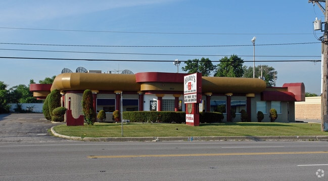
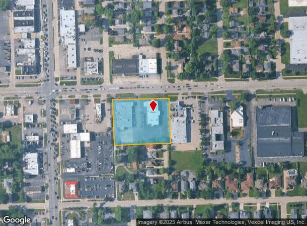
Property Record
9901 W 55Th St, Countryside, IL 60525

Current Lease Availabilities
NEARBY LISTINGS FOR SALE OR LEASE
Property Detail
9901 W 55Th St
18-16-200-042-0000
Aherns Subdivision
Commercialbuilding
Cook
X
Illinois
17031C0486J
2 AC
2023
Eastern East/West Corr
2024
Chicago
820103
Chicago-Naperville-Elgin, IL-IN-WI
21,891 SF
DEMOGRAPHICS near 9901 W 55Th St
1 Mile
3 Mile
5 Mile
2024 Total Population
9,336
91,596
276,676
2029 Population
9,013
89,192
269,727
Pop Growth 2024-2029
(3.46%)
(2.62%)
(2.51%)
Average Age
41
41
42
2024 Total Households
3,479
33,062
102,091
HH Growth 2024-2029
(3.88%)
(3.00%)
(2.80%)
Median Household Inc
$90,497
$104,271
$90,868
Avg Household Size
2.60
2.70
2.60
2024 Avg HH Vehicles
2.00
2.00
2.00
Median Home Value
$391,061
$393,384
$325,248
Median Year Built
1965
1959
1962
Nearby Places
- Restaurants
- Banks
- Shops
- Fitness
- Groceries
PUBLIC TRANSPORTATION
COMMUTER RAIL
Lagrange Road Station (Burlington Northern-Santa Fe Railway Line - Northeast Illinois Regional Commuter Railroad (Metra))
DRIVE
WALK
Distance
Lagrange Road Station (Burlington Northern-Santa Fe Railway Line - Northeast Illinois Regional Commuter Railroad (Metra))
4 min
2.1 mi
Lagrange/Stone Avenue Station (Burlington Northern-Santa Fe Railway Line - Northeast Illinois Regional Commuter Railroad (Metra))
DRIVE
WALK
Distance
Lagrange/Stone Avenue Station (Burlington Northern-Santa Fe Railway Line - Northeast Illinois Regional Commuter Railroad (Metra))
5 min
2.4 mi
AIRPORT
Chicago Midway International
DRIVE
WALK
Distance
Chicago Midway International
10 min
6.3 mi
Chicago O'Hare International
DRIVE
WALK
Distance
Chicago O'Hare International
28 min
15.6 mi
Freight Ports
Port Milwaukee
DRIVE
WALK
Distance
Port Milwaukee
111 min
91.9 mi
Nearby Properties
Address
Land Use
TOTAL SIZE
Lot Size
Zoning
Address
Land Use
TOTAL SIZE
Lot Size
Zoning
424,376 SF
3.48 AC
Address
Land Use
TOTAL SIZE
Lot Size
Zoning
445,440 SF
24.50 AC
Address
Land Use
TOTAL SIZE
Lot Size
Zoning
140,579 SF
11.30 AC
Address
Land Use
TOTAL SIZE
Lot Size
Zoning
1,182,079 SF
Address
Land Use
TOTAL SIZE
Lot Size
Zoning
61,003 SF
68.78 AC
Address
Land Use
TOTAL SIZE
Lot Size
Zoning
134,361 SF
4.09 AC
Address
Land Use
TOTAL SIZE
Lot Size
Zoning
49,503 SF
1.47 AC
Address
Land Use
TOTAL SIZE
Lot Size
Zoning
274,900 SF
13.14 AC
Address
Land Use
TOTAL SIZE
Lot Size
Zoning
140,814 SF
Address
Land Use
TOTAL SIZE
Lot Size
Zoning
313,899 SF
13.43 AC
Address
Land Use
TOTAL SIZE
Lot Size
Zoning
Address
Land Use
TOTAL SIZE
Lot Size
Zoning
124.04 AC
Address
Land Use
TOTAL SIZE
Lot Size
Zoning
Address
Land Use
TOTAL SIZE
Lot Size
Zoning
11.53 AC
Address
Land Use
TOTAL SIZE
Lot Size
Zoning
44,863 SF
9.87 AC
COM-2
Address
Land Use
TOTAL SIZE
Lot Size
Zoning
98,811 SF
10.02 AC
Address
Land Use
TOTAL SIZE
Lot Size
Zoning
8.32 AC
Address
Land Use
TOTAL SIZE
Lot Size
Zoning
99.88 AC
Address
Land Use
TOTAL SIZE
Lot Size
Zoning
317,321 SF
15.99 AC
Address
Land Use
TOTAL SIZE
Lot Size
Zoning
117,394 SF
9.33 AC
Address
Land Use
TOTAL SIZE
Lot Size
Zoning
358,212 SF
17.87 AC
Address
Land Use
TOTAL SIZE
Lot Size
Zoning
123,388 SF
11.14 AC
Address
Land Use
TOTAL SIZE
Lot Size
Zoning
46,244 SF
3.16 AC
Address
Land Use
TOTAL SIZE
Lot Size
Zoning
1,583,756 SF
78.72 AC
Address
Land Use
TOTAL SIZE
Lot Size
Zoning
2,056,254 SF
22.98 AC
Address
Land Use
TOTAL SIZE
Lot Size
Zoning
188,000 SF
8.91 AC
Address
Land Use
TOTAL SIZE
Lot Size
Zoning
3.51 AC
Address
Land Use
TOTAL SIZE
Lot Size
Zoning
246,248 SF
19.35 AC
Address
Land Use
TOTAL SIZE
Lot Size
Zoning
226,088 SF
12.95 AC
Address
Land Use
TOTAL SIZE
Lot Size
Zoning
80.10 AC
The World's #1 Commercial Real Estate Marketplace
Connect with us
© 2025 CoStar Group
The information above has been obtained from sources believed reliable. While we do not doubt its accuracy we have not verified it and make no guarantee, warranty or representation about it. It is your responsibility to independently confirm its accuracy and completeness. Any projections, opinions, assumptions, or estimates used are for example only and do not represent the current or future performance of the property. The value of this transaction to you depends on tax and other factors which should be evaluated by your tax, financial, and legal advisors. You and your advisors should conduct a careful, independent investigation of the property to determine to your satisfaction the suitability of the property for your needs.