Property Record
9909 W Primrose, Edwards, IL 61528
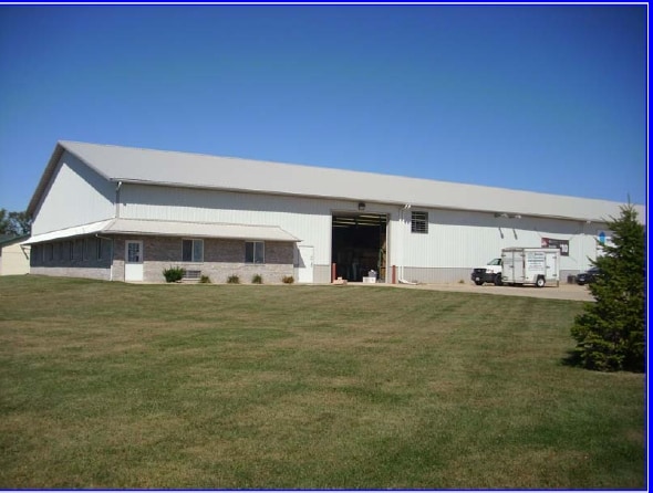

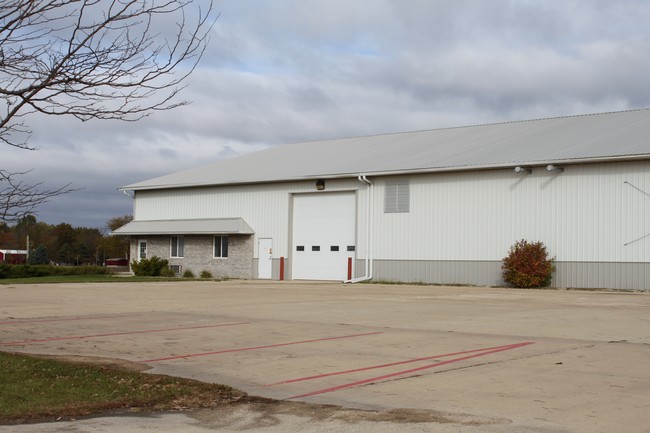
Property Detail
9909 W Primrose
Peoria
CENTENNIAL DEVELOPMENT NO 1 SW 1/4 SEC 5-9N-7E 2.128 AC LOT 6
Peoria, IL
Peoria
13-06-376-015
Illinois
Commercialnec
6
2024
2.13 AC
2024
Outlying Peoria County
004101
NEARBY LISTINGS FOR SALE OR LEASE
-
-
View all Edwards listings for sale on LoopNet.com
DEMOGRAPHICS near 9909 W Primrose
1 mile
3 mile
5 mile
2025 Total Population
270
2,418
12,265
2030 Population
265
2,388
12,156
Pop Growth 2025-2030
(1.85%)
(1.24%)
(0.89%)
Average Age
43
42
40
2025 Total Households
105
900
4,751
HH Growth 2025-2030
(1.90%)
(1.33%)
(1.01%)
Median Household Inc
$173,000
$154,738
$128,651
Avg Household Size
2.60
2.70
2.50
2025 Avg HH Vehicles
2.00
2.00
2.00
Median Home Value
$306,667
$334,593
$296,149
Median Year Built
1969
1989
1992
Nearby Places
Map Layers
Map Styles
 Street
 Aerial
Layers
 Traffic
 Biking
Places
Listings with unknown addresses are not visible on the map
- Restaurants
- Banks
- Shops
- Fitness
- Groceries
PUBLIC TRANSPORTATION
AIRPORT
General Downing - Peoria International
Drive
Walk
Distance
General Downing - Peoria International
20 min
12.8 mi
Freight Ports
Port Milwaukee
Drive
Walk
Distance
Port Milwaukee
271 min
227.0 mi
SALE & LEASE HISTORY
LISTING DATE
SALE/LEASE

Sep 25, 2016
For Lease
May 10, 2019
For Sale
Nearby Properties
Address
Land Use
TOTAL SIZE
Lot Size
Zoning
Address
Land Use
TOTAL SIZE
Lot Size
Zoning
43.09 AC
Address
Land Use
TOTAL SIZE
Lot Size
Zoning
160 AC
Address
Land Use
TOTAL SIZE
Lot Size
Zoning
5.56 AC
Address
Land Use
TOTAL SIZE
Lot Size
Zoning
Address
Land Use
TOTAL SIZE
Lot Size
Zoning
Address
Land Use
TOTAL SIZE
Lot Size
Zoning
Address
Land Use
TOTAL SIZE
Lot Size
Zoning
7,560 SF
38.03 AC
Address
Land Use
TOTAL SIZE
Lot Size
Zoning
Address
Land Use
TOTAL SIZE
Lot Size
Zoning
7,668 SF
52.44 AC
Address
Land Use
TOTAL SIZE
Lot Size
Zoning
2,400 SF
3.54 AC
Address
Land Use
TOTAL SIZE
Lot Size
Zoning
6,966 SF
10.27 AC
Address
Land Use
TOTAL SIZE
Lot Size
Zoning
13,198 SF
67.05 AC
Address
Land Use
TOTAL SIZE
Lot Size
Zoning
4,000 SF
25 AC
Address
Land Use
TOTAL SIZE
Lot Size
Zoning
Address
Land Use
TOTAL SIZE
Lot Size
Zoning
1,341 SF
13.17 AC
Address
Land Use
TOTAL SIZE
Lot Size
Zoning
Address
Land Use
TOTAL SIZE
Lot Size
Zoning
7,814 SF
30.02 AC
Address
Land Use
TOTAL SIZE
Lot Size
Zoning
11,339 SF
70.40 AC
Address
Land Use
TOTAL SIZE
Lot Size
Zoning
6,636 SF
5.16 AC
Address
Land Use
TOTAL SIZE
Lot Size
Zoning
1.51 AC
Address
Land Use
TOTAL SIZE
Lot Size
Zoning
6,921 SF
19.48 AC
Address
Land Use
TOTAL SIZE
Lot Size
Zoning
1.63 AC
Address
Land Use
TOTAL SIZE
Lot Size
Zoning
5,554 SF
9.98 AC
Address
Land Use
TOTAL SIZE
Lot Size
Zoning
25.47 AC
Address
Land Use
TOTAL SIZE
Lot Size
Zoning
6,296 SF
22.99 AC
Address
Land Use
TOTAL SIZE
Lot Size
Zoning
7,575 SF
26.45 AC
Address
Land Use
TOTAL SIZE
Lot Size
Zoning
5,463 SF
6.32 AC
Address
Land Use
TOTAL SIZE
Lot Size
Zoning
6,190 SF
38.16 AC
Address
Land Use
TOTAL SIZE
Lot Size
Zoning
8,063 SF
79.97 AC
The World's #1 Commercial Real Estate Marketplace
Connect with us
© 2026 CoStar Group
The information above has been obtained from sources believed reliable. While we do not doubt its accuracy we have not verified it and make no guarantee, warranty or representation about it. It is your responsibility to independently confirm its accuracy and completeness. Any projections, opinions, assumptions, or estimates used are for example only and do not represent the current or future performance of the property. The value of this transaction to you depends on tax and other factors which should be evaluated by your tax, financial, and legal advisors. You and your advisors should conduct a careful, independent investigation of the property to determine to your satisfaction the suitability of the property for your needs.