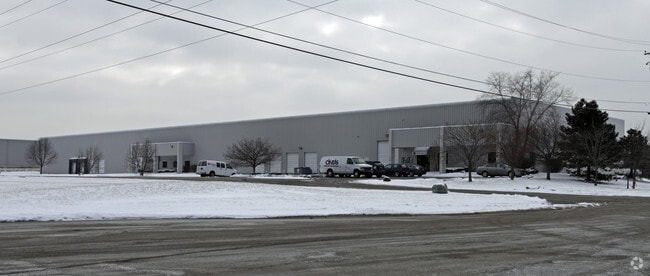
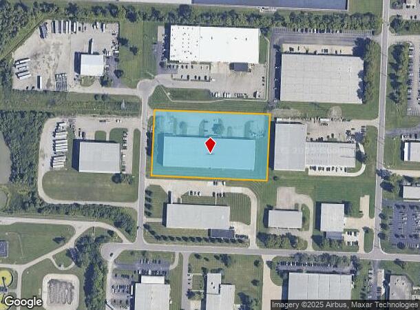
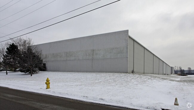
Property Record
9910 Charter Park Dr, West Chester, OH 45069

NEARBY LISTINGS FOR SALE OR LEASE
Property Detail
9910 Charter Park Dr
Cincinnati, OH-KY-IN
Schumacher
M5620-282-000-006
9 ENT SCHUMACHER COMMERCE PARK
Warehouse
Butler
X
Ohio
39017C0341F
9
2024
3.40 AC
2024
Tri-County
011131
Cincinnati/Dayton
57,322 SF
DEMOGRAPHICS near 9910 Charter Park Dr
1 Mile
3 Mile
5 Mile
2024 Total Population
1,286
33,424
138,363
2029 Population
1,290
33,591
140,010
Pop Growth 2024-2029
+ 0.31%
+ 0.50%
+ 1.19%
Average Age
41
40
40
2024 Total Households
502
13,100
53,890
HH Growth 2024-2029
+ 0.20%
+ 0.40%
+ 1.15%
Median Household Inc
$110,138
$83,791
$87,752
Avg Household Size
2.50
2.50
2.50
2024 Avg HH Vehicles
2.00
2.00
2.00
Median Home Value
$283,625
$254,996
$250,602
Median Year Built
1995
1983
1983
Nearby Places
Map Layers
Map Styles
 Street
 Aerial
- Restaurants
- Banks
- Shops
- Fitness
- Groceries
PUBLIC TRANSPORTATION
AIRPORT
Cincinnati/Northern Kentucky International
DRIVE
WALK
Distance
Cincinnati/Northern Kentucky International
55 min
32.8 mi
Nearby Properties
Address
Land Use
TOTAL SIZE
Lot Size
Zoning
Address
Land Use
TOTAL SIZE
Lot Size
Zoning
47.52 AC
Address
Land Use
TOTAL SIZE
Lot Size
Zoning
987,717 SF
57.32 AC
Address
Land Use
TOTAL SIZE
Lot Size
Zoning
61.62 AC
Address
Land Use
TOTAL SIZE
Lot Size
Zoning
1,398,190 SF
54.91 AC
Address
Land Use
TOTAL SIZE
Lot Size
Zoning
54,055 SF
18.17 AC
Address
Land Use
TOTAL SIZE
Lot Size
Zoning
69.99 AC
Address
Land Use
TOTAL SIZE
Lot Size
Zoning
342,284 SF
37.92 AC
Address
Land Use
TOTAL SIZE
Lot Size
Zoning
914,426 SF
41.39 AC
Address
Land Use
TOTAL SIZE
Lot Size
Zoning
782,765 SF
33.15 AC
Address
Land Use
TOTAL SIZE
Lot Size
Zoning
15.33 AC
Address
Land Use
TOTAL SIZE
Lot Size
Zoning
287,883 SF
10.90 AC
Address
Land Use
TOTAL SIZE
Lot Size
Zoning
4,620 SF
85.80 AC
Address
Land Use
TOTAL SIZE
Lot Size
Zoning
68.49 AC
Address
Land Use
TOTAL SIZE
Lot Size
Zoning
84,133 SF
4.28 AC
Address
Land Use
TOTAL SIZE
Lot Size
Zoning
498,300 SF
14.86 AC
Address
Land Use
TOTAL SIZE
Lot Size
Zoning
26.63 AC
Address
Land Use
TOTAL SIZE
Lot Size
Zoning
10.76 AC
Address
Land Use
TOTAL SIZE
Lot Size
Zoning
11.19 AC
Address
Land Use
TOTAL SIZE
Lot Size
Zoning
Address
Land Use
TOTAL SIZE
Lot Size
Zoning
536,648 SF
22.28 AC
Address
Land Use
TOTAL SIZE
Lot Size
Zoning
25.89 AC
Address
Land Use
TOTAL SIZE
Lot Size
Zoning
434,916 SF
19.98 AC
Address
Land Use
TOTAL SIZE
Lot Size
Zoning
417,137 SF
47.57 AC
Address
Land Use
TOTAL SIZE
Lot Size
Zoning
76.09 AC
Address
Land Use
TOTAL SIZE
Lot Size
Zoning
433,277 SF
25.66 AC
Address
Land Use
TOTAL SIZE
Lot Size
Zoning
115,697 SF
6.89 AC
Address
Land Use
TOTAL SIZE
Lot Size
Zoning
Address
Land Use
TOTAL SIZE
Lot Size
Zoning
54.92 AC
Address
Land Use
TOTAL SIZE
Lot Size
Zoning
433,309 SF
21.87 AC
Address
Land Use
TOTAL SIZE
Lot Size
Zoning
9,744 SF
8.15 AC
The World's #1 Commercial Real Estate Marketplace
Connect with us
© 2025 CoStar Group
The information above has been obtained from sources believed reliable. While we do not doubt its accuracy we have not verified it and make no guarantee, warranty or representation about it. It is your responsibility to independently confirm its accuracy and completeness. Any projections, opinions, assumptions, or estimates used are for example only and do not represent the current or future performance of the property. The value of this transaction to you depends on tax and other factors which should be evaluated by your tax, financial, and legal advisors. You and your advisors should conduct a careful, independent investigation of the property to determine to your satisfaction the suitability of the property for your needs.