Property Record
9912 37Th Ave, Corona, NY 11368
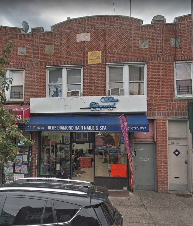

Property Detail
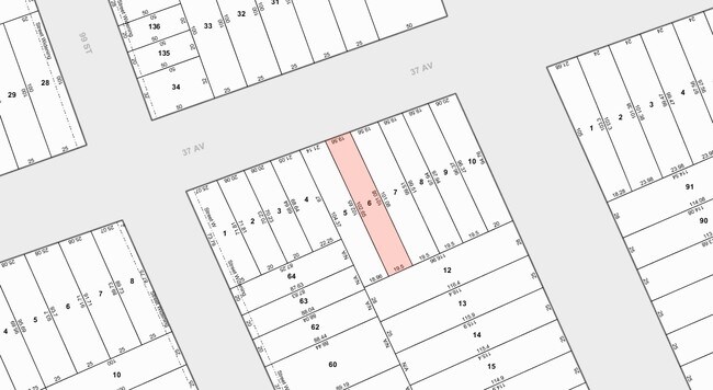
9912 37Th Ave
01762-0006
Queens
Commercialofficeresidentialmixeduse
New York
R6B
6
B and X Area of moderate flood hazard, usually the area between the limits of the 100-year and 500-year floods.
0.05 AC
2024
Northeast Queens
2025
Long Island (New York)
040702
New York-Jersey City-White Plains, NY-NJ
2,602 SF
NEARBY LISTINGS FOR SALE OR LEASE
DEMOGRAPHICS near 9912 37Th Ave
1 mile
3 mile
5 mile
2024 Total Population
194,427
861,638
2,080,190
2029 Population
179,508
809,163
1,944,263
Pop Growth 2024-2029
(7.67%)
(6.09%)
(6.53%)
Average Age
39
42
40
2024 Total Households
57,057
309,393
788,099
HH Growth 2024-2029
(7.74%)
(6.16%)
(6.70%)
Median Household Inc
$63,095
$68,392
$73,098
Avg Household Size
3.20
2.70
2.50
2024 Avg HH Vehicles
1.00
1.00
1.00
Median Home Value
$604,099
$657,601
$730,702
Median Year Built
1951
1953
1954
Nearby Places
Map Layers
Map Styles
 Street
 Aerial
Transit
 Traffic
 Biking
Places
Listings with unknown addresses are not visible on the map
- Restaurants
- Banks
- Shops
- Fitness
- Groceries
Nearby Properties
Address
Land Use
TOTAL SIZE
Lot Size
Zoning
Address
Land Use
TOTAL SIZE
Lot Size
Zoning
2,078,606 SF
58.93 AC
R4
Address
Land Use
TOTAL SIZE
Lot Size
Zoning
1,258,350 SF
410.24 AC
PARK
Address
Land Use
TOTAL SIZE
Lot Size
Zoning
1,502,532 SF
6.35 AC
R7B
Address
Land Use
TOTAL SIZE
Lot Size
Zoning
772,163 SF
5.24 AC
C4-5X
Address
Land Use
TOTAL SIZE
Lot Size
Zoning
1,292,074 SF
C4-2F
Address
Land Use
TOTAL SIZE
Lot Size
Zoning
234,891 SF
3.17 AC
C4-5X
Address
Land Use
TOTAL SIZE
Lot Size
Zoning
1,516,458 SF
5.97 AC
R7-1
Address
Land Use
TOTAL SIZE
Lot Size
Zoning
15,000 SF
255.27 AC
PARK
Address
Land Use
TOTAL SIZE
Lot Size
Zoning
1,000 SF
210.07 AC
R3-2
Address
Land Use
TOTAL SIZE
Lot Size
Zoning
332,266 SF
12.57 AC
M2-1
Address
Land Use
TOTAL SIZE
Lot Size
Zoning
344,116 SF
0.92 AC
R7-1
Address
Land Use
TOTAL SIZE
Lot Size
Zoning
577,654 SF
5.38 AC
R6
Address
Land Use
TOTAL SIZE
Lot Size
Zoning
521,944 SF
16.68 AC
R4
Address
Land Use
TOTAL SIZE
Lot Size
Zoning
360,000 SF
5.88 AC
C4-2
Address
Land Use
TOTAL SIZE
Lot Size
Zoning
480,000 SF
16.98 AC
M1-1
Address
Land Use
TOTAL SIZE
Lot Size
Zoning
248,200 SF
1.25 AC
R6
Address
Land Use
TOTAL SIZE
Lot Size
Zoning
250,577 SF
23.17 AC
M2-1
Address
Land Use
TOTAL SIZE
Lot Size
Zoning
266,195 SF
4.59 AC
C4-2
Address
Land Use
TOTAL SIZE
Lot Size
Zoning
272,081 SF
4.59 AC
C4-2
Address
Land Use
TOTAL SIZE
Lot Size
Zoning
240,000 SF
2.09 AC
R6
Address
Land Use
TOTAL SIZE
Lot Size
Zoning
281,416 SF
2.57 AC
C4-2
Address
Land Use
TOTAL SIZE
Lot Size
Zoning
192,200 SF
9.70 AC
R4
Address
Land Use
TOTAL SIZE
Lot Size
Zoning
454,631 SF
24.61 AC
M1-1
Address
Land Use
TOTAL SIZE
Lot Size
Zoning
4,279,575 SF
144.16 AC
PARK
Address
Land Use
TOTAL SIZE
Lot Size
Zoning
443,492 SF
27.75 AC
M1-1
Address
Land Use
TOTAL SIZE
Lot Size
Zoning
207,407 SF
3.73 AC
R6B
Address
Land Use
TOTAL SIZE
Lot Size
Zoning
454,645 SF
0.95 AC
C4-4
Address
Land Use
TOTAL SIZE
Lot Size
Zoning
306,387 SF
1.46 AC
R7X
Address
Land Use
TOTAL SIZE
Lot Size
Zoning
325,300 SF
7.71 AC
R5D
Address
Land Use
TOTAL SIZE
Lot Size
Zoning
202,615 SF
1.33 AC
R7-1
The World's #1 Commercial Real Estate Marketplace
Connect with us
© 2026 CoStar Group
The information above has been obtained from sources believed reliable. While we do not doubt its accuracy we have not verified it and make no guarantee, warranty or representation about it. It is your responsibility to independently confirm its accuracy and completeness. Any projections, opinions, assumptions, or estimates used are for example only and do not represent the current or future performance of the property. The value of this transaction to you depends on tax and other factors which should be evaluated by your tax, financial, and legal advisors. You and your advisors should conduct a careful, independent investigation of the property to determine to your satisfaction the suitability of the property for your needs.