Property Record
9913 Rutledge Pike, Corryton, TN 37721
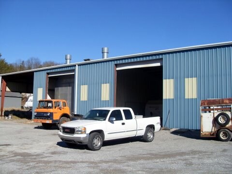

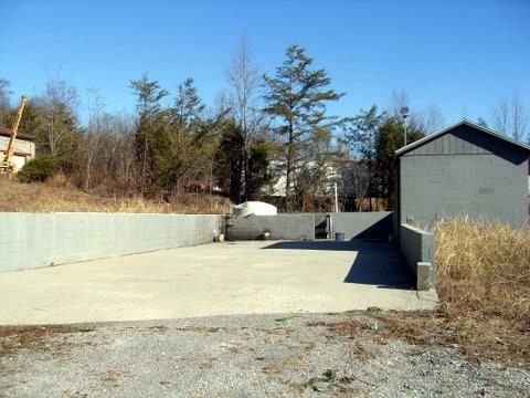
Property Detail
9913 Rutledge Pike
032-11303
MAPPLATB 79L MAPPLATP 94
Autorepair
KNOX
B and X Area of moderate flood hazard, usually the area between the limits of the 100-year and 500-year floods.
Tennessee
2025
5.20 AC
2025
East
006501
Knoxville
9,928 SF
Knoxville, TN
NEARBY LISTINGS FOR SALE OR LEASE
DEMOGRAPHICS near 9913 Rutledge Pike
1 mile
3 mile
5 mile
2025 Total Population
634
5,749
16,798
2030 Population
667
6,048
17,722
Pop Growth 2025-2030
+ 5.21%
+ 5.20%
+ 5.50%
Average Age
42
42
42
2025 Total Households
253
2,261
6,599
HH Growth 2025-2030
+ 5.14%
+ 5.17%
+ 5.49%
Median Household Inc
$65,322
$57,178
$60,823
Avg Household Size
2.50
2.50
2.50
2025 Avg HH Vehicles
2.00
2.00
2.00
Median Home Value
$282,407
$290,216
$285,375
Median Year Built
1985
1987
1991
Nearby Places
Map Layers
Map Styles
 Street
 Aerial
Layers
 Traffic
 Biking
Places
Listings with unknown addresses are not visible on the map
- Restaurants
- Banks
- Shops
- Fitness
- Groceries
PUBLIC TRANSPORTATION
AIRPORT
McGhee Tyson
Drive
Walk
Distance
McGhee Tyson
47 min
31.8 mi
Freight Ports
North Charleston Terminal
Drive
Walk
Distance
North Charleston Terminal
416 min
358.4 mi
Nearby Properties
Address
Land Use
TOTAL SIZE
Lot Size
Zoning
Address
Land Use
TOTAL SIZE
Lot Size
Zoning
427,949 SF
139.04 AC
Address
Land Use
TOTAL SIZE
Lot Size
Zoning
130,834 SF
18.05 AC
Address
Land Use
TOTAL SIZE
Lot Size
Zoning
122,500 SF
15.31 AC
Address
Land Use
TOTAL SIZE
Lot Size
Zoning
130,560 SF
19.33 AC
Address
Land Use
TOTAL SIZE
Lot Size
Zoning
46,080 SF
6.66 AC
Address
Land Use
TOTAL SIZE
Lot Size
Zoning
16,254 SF
8.80 AC
Address
Land Use
TOTAL SIZE
Lot Size
Zoning
44,522 SF
11.49 AC
Address
Land Use
TOTAL SIZE
Lot Size
Zoning
9,432 SF
8.58 AC
Address
Land Use
TOTAL SIZE
Lot Size
Zoning
1,200 SF
402.70 AC
Address
Land Use
TOTAL SIZE
Lot Size
Zoning
4,000 SF
3.81 AC
Address
Land Use
TOTAL SIZE
Lot Size
Zoning
19,286 SF
10 AC
Address
Land Use
TOTAL SIZE
Lot Size
Zoning
9,100 SF
3.15 AC
Address
Land Use
TOTAL SIZE
Lot Size
Zoning
9,400 SF
3.02 AC
Address
Land Use
TOTAL SIZE
Lot Size
Zoning
3,290 SF
1.56 AC
Address
Land Use
TOTAL SIZE
Lot Size
Zoning
11.17 AC
Address
Land Use
TOTAL SIZE
Lot Size
Zoning
13,080 SF
0.50 AC
Address
Land Use
TOTAL SIZE
Lot Size
Zoning
39.53 AC
Address
Land Use
TOTAL SIZE
Lot Size
Zoning
9,450 SF
1.02 AC
Address
Land Use
TOTAL SIZE
Lot Size
Zoning
2,120 SF
10 AC
Address
Land Use
TOTAL SIZE
Lot Size
Zoning
5,475 SF
5 AC
Address
Land Use
TOTAL SIZE
Lot Size
Zoning
3,600 SF
0.92 AC
Address
Land Use
TOTAL SIZE
Lot Size
Zoning
6,350 SF
6.75 AC
Address
Land Use
TOTAL SIZE
Lot Size
Zoning
3,772 SF
1.01 AC
Address
Land Use
TOTAL SIZE
Lot Size
Zoning
115.95 AC
Address
Land Use
TOTAL SIZE
Lot Size
Zoning
7,650 SF
0.94 AC
Address
Land Use
TOTAL SIZE
Lot Size
Zoning
2,280 SF
0.75 AC
Address
Land Use
TOTAL SIZE
Lot Size
Zoning
5,600 SF
1.11 AC
Address
Land Use
TOTAL SIZE
Lot Size
Zoning
4,826 SF
1.38 AC
Address
Land Use
TOTAL SIZE
Lot Size
Zoning
2,800 SF
1.35 AC
The World's #1 Commercial Real Estate Marketplace
Connect with us
© 2026 CoStar Group
The information above has been obtained from sources believed reliable. While we do not doubt its accuracy we have not verified it and make no guarantee, warranty or representation about it. It is your responsibility to independently confirm its accuracy and completeness. Any projections, opinions, assumptions, or estimates used are for example only and do not represent the current or future performance of the property. The value of this transaction to you depends on tax and other factors which should be evaluated by your tax, financial, and legal advisors. You and your advisors should conduct a careful, independent investigation of the property to determine to your satisfaction the suitability of the property for your needs.