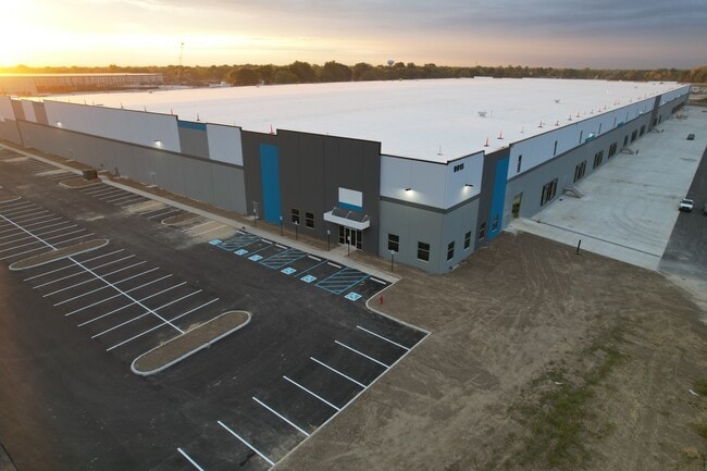
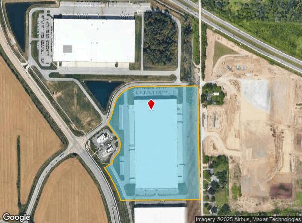
Property Record
9915 Lacy Knot Dr, Brownsburg, IN 46112
NEARBY LISTINGS FOR SALE OR LEASE
Property Detail
9915 Lacy Knot Dr
Indianapolis
Ronald Reagan Logistics Park
Indianapolis-Carmel-Greenwood, IN
RONALD REAGANLOGISTICS PARK I-74 LOT-2 32.50AC
32-08-18-210-002.000-016
Hendricks
Warehouse
Indiana
2024
32.50 AC
2024
West Hendricks Cty
210109
DEMOGRAPHICS near 9915 Lacy Knot Dr
1 Mile
3 Mile
5 Mile
2024 Total Population
2,353
48,954
147,785
2029 Population
2,623
53,457
155,618
Pop Growth 2024-2029
+ 11.47%
+ 9.20%
+ 5.30%
Average Age
37
38
37
2024 Total Households
858
18,429
56,416
HH Growth 2024-2029
+ 11.54%
+ 8.90%
+ 4.91%
Median Household Inc
$81,508
$94,936
$75,930
Avg Household Size
2.60
2.60
2.60
2024 Avg HH Vehicles
2.00
2.00
2.00
Median Home Value
$179,051
$220,329
$214,927
Median Year Built
2002
1997
1991
Nearby Places
Map Layers
Map Styles
 Street
 Aerial
- Restaurants
- Banks
- Shops
- Fitness
- Groceries
PUBLIC TRANSPORTATION
AIRPORT
Indianapolis International
DRIVE
WALK
Distance
Indianapolis International
25 min
12.6 mi
Freight Ports
Port of Toledo
DRIVE
WALK
Distance
Port of Toledo
284 min
233.1 mi
SALE & LEASE HISTORY
LISTING DATE
SALE/LEASE

Aug 13, 2021
For Lease
Nearby Properties
Address
Land Use
TOTAL SIZE
Lot Size
Zoning
Address
Land Use
TOTAL SIZE
Lot Size
Zoning
56.57 AC
Address
Land Use
TOTAL SIZE
Lot Size
Zoning
805,018 SF
48.20 AC
Address
Land Use
TOTAL SIZE
Lot Size
Zoning
683,528 SF
43.54 AC
Address
Land Use
TOTAL SIZE
Lot Size
Zoning
773,129 SF
36.12 AC
Address
Land Use
TOTAL SIZE
Lot Size
Zoning
Address
Land Use
TOTAL SIZE
Lot Size
Zoning
244,838 SF
3.01 AC
Address
Land Use
TOTAL SIZE
Lot Size
Zoning
225,712 SF
2.22 AC
Address
Land Use
TOTAL SIZE
Lot Size
Zoning
3,712 SF
17.58 AC
Address
Land Use
TOTAL SIZE
Lot Size
Zoning
5,189 SF
19.05 AC
Address
Land Use
TOTAL SIZE
Lot Size
Zoning
526,200 SF
28.31 AC
Address
Land Use
TOTAL SIZE
Lot Size
Zoning
405,824 SF
32.37 AC
Address
Land Use
TOTAL SIZE
Lot Size
Zoning
3,348 SF
32.01 AC
ZO01
Address
Land Use
TOTAL SIZE
Lot Size
Zoning
456 SF
50.27 AC
Address
Land Use
TOTAL SIZE
Lot Size
Zoning
29.46 AC
Address
Land Use
TOTAL SIZE
Lot Size
Zoning
396,768 SF
20.88 AC
Address
Land Use
TOTAL SIZE
Lot Size
Zoning
24.15 AC
Address
Land Use
TOTAL SIZE
Lot Size
Zoning
86,706 SF
19.47 AC
Address
Land Use
TOTAL SIZE
Lot Size
Zoning
Address
Land Use
TOTAL SIZE
Lot Size
Zoning
80,046 SF
13.65 AC
Address
Land Use
TOTAL SIZE
Lot Size
Zoning
18.29 AC
Address
Land Use
TOTAL SIZE
Lot Size
Zoning
Address
Land Use
TOTAL SIZE
Lot Size
Zoning
99,038 SF
7.09 AC
Address
Land Use
TOTAL SIZE
Lot Size
Zoning
17,500 SF
33.72 AC
Address
Land Use
TOTAL SIZE
Lot Size
Zoning
Address
Land Use
TOTAL SIZE
Lot Size
Zoning
Address
Land Use
TOTAL SIZE
Lot Size
Zoning
75,809 SF
7.91 AC
Address
Land Use
TOTAL SIZE
Lot Size
Zoning
5,934 SF
9.78 AC
Address
Land Use
TOTAL SIZE
Lot Size
Zoning
6,586 SF
110.97 AC
Address
Land Use
TOTAL SIZE
Lot Size
Zoning
6,540 SF
18.79 AC
ZO01
The World's #1 Commercial Real Estate Marketplace
Connect with us
© 2026 CoStar Group
The information above has been obtained from sources believed reliable. While we do not doubt its accuracy we have not verified it and make no guarantee, warranty or representation about it. It is your responsibility to independently confirm its accuracy and completeness. Any projections, opinions, assumptions, or estimates used are for example only and do not represent the current or future performance of the property. The value of this transaction to you depends on tax and other factors which should be evaluated by your tax, financial, and legal advisors. You and your advisors should conduct a careful, independent investigation of the property to determine to your satisfaction the suitability of the property for your needs.