Property Record
9925 Us Highway 441, Leesburg, FL 34788
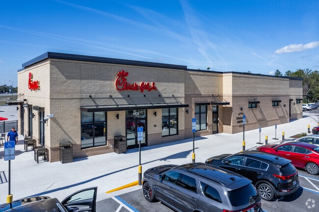

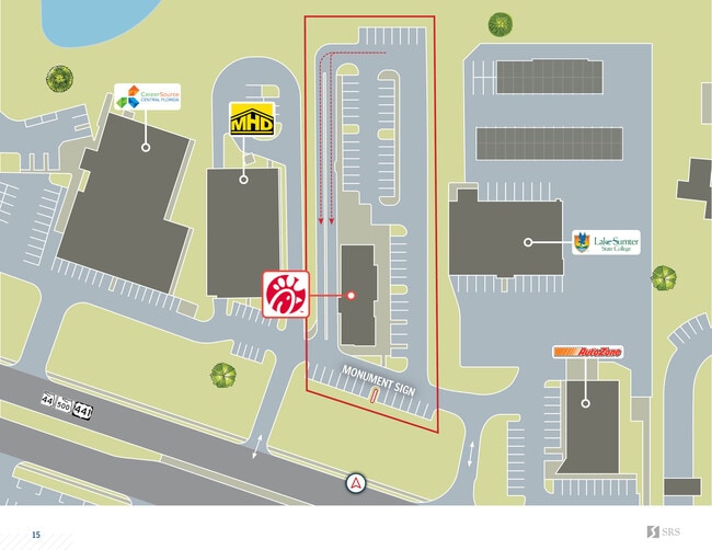
This Property Is For Sale
NEARBY LISTINGS FOR SALE OR LEASE
Property Detail
9925 Us Highway 441
Orlando-Kissimmee-Sanford, FL
Silver Lake Estates
01-19-25-0500-047-00800
SILVER LAKE ESTATES THAT PART OF LOT 8 BLK 47 IN SEC 22-19-25 DESCRIBED AS FOLLOWS: FROM E 1/4 COR OF SEC RUN N 00DEG 44MIN 50SEC W 817.03 FT TO A POINT ON N R/W LINE OF US HWY 441 FOR POB RUN N 71DEG 57MIN 39SEC W ALONG SAID R/W LINE 165.83 FT N 00D
Restaurantdrivein
Lake
X
Florida
12069C0333E
8
2024
1.67 AC
2026
Lake County
030302
Orlando
5,130 SF
DEMOGRAPHICS near 9925 Us Highway 441
1 Mile
3 Mile
5 Mile
2024 Total Population
3,993
22,035
49,713
2029 Population
4,655
25,821
58,584
Pop Growth 2024-2029
+ 16.58%
+ 17.18%
+ 17.84%
Average Age
47
47
48
2024 Total Households
1,787
9,678
22,080
HH Growth 2024-2029
+ 16.40%
+ 17.06%
+ 17.89%
Median Household Inc
$53,884
$53,073
$52,130
Avg Household Size
2.20
2.30
2.20
2024 Avg HH Vehicles
2.00
2.00
2.00
Median Home Value
$114,815
$172,646
$174,799
Median Year Built
1990
1987
1987
Nearby Places
Map Layers
Map Styles
 Street
 Aerial
- Restaurants
- Banks
- Shops
- Fitness
- Groceries
PUBLIC TRANSPORTATION
AIRPORT
Orlando Sanford International
DRIVE
WALK
Distance
Orlando Sanford International
65 min
43.1 mi
Nearby Properties
Address
Land Use
TOTAL SIZE
Lot Size
Zoning
Address
Land Use
TOTAL SIZE
Lot Size
Zoning
137,651 SF
17.35 AC
RMRP
Address
Land Use
TOTAL SIZE
Lot Size
Zoning
131,655 SF
9.98 AC
RP
Address
Land Use
TOTAL SIZE
Lot Size
Zoning
5,760 SF
110.52 AC
R1
Address
Land Use
TOTAL SIZE
Lot Size
Zoning
546,456 SF
56.22 AC
RP
Address
Land Use
TOTAL SIZE
Lot Size
Zoning
972 SF
565.39 AC
A
Address
Land Use
TOTAL SIZE
Lot Size
Zoning
183,700 SF
11.66 AC
R2
Address
Land Use
TOTAL SIZE
Lot Size
Zoning
60,700 SF
784.12 AC
P
Address
Land Use
TOTAL SIZE
Lot Size
Zoning
137,622 SF
18.33 AC
C3
Address
Land Use
TOTAL SIZE
Lot Size
Zoning
39,164 SF
7.25 AC
Address
Land Use
TOTAL SIZE
Lot Size
Zoning
162,928 SF
9.52 AC
R3
Address
Land Use
TOTAL SIZE
Lot Size
Zoning
81,821 SF
12.30 AC
Address
Land Use
TOTAL SIZE
Lot Size
Zoning
40,776 SF
2.28 AC
C1
Address
Land Use
TOTAL SIZE
Lot Size
Zoning
48,478 SF
1.61 AC
CIP
Address
Land Use
TOTAL SIZE
Lot Size
Zoning
77,075 SF
4.66 AC
CP
Address
Land Use
TOTAL SIZE
Lot Size
Zoning
109,792 SF
11.83 AC
RMRP
Address
Land Use
TOTAL SIZE
Lot Size
Zoning
37,310 SF
4.39 AC
Address
Land Use
TOTAL SIZE
Lot Size
Zoning
37,983 SF
5.54 AC
C3
Address
Land Use
TOTAL SIZE
Lot Size
Zoning
124,495 SF
6.49 AC
R3
Address
Land Use
TOTAL SIZE
Lot Size
Zoning
86.22 AC
PD
Address
Land Use
TOTAL SIZE
Lot Size
Zoning
32,704 SF
6.12 AC
R1
Address
Land Use
TOTAL SIZE
Lot Size
Zoning
20,559 SF
5.21 AC
Address
Land Use
TOTAL SIZE
Lot Size
Zoning
33,675 SF
2.74 AC
Address
Land Use
TOTAL SIZE
Lot Size
Zoning
53,312 SF
3.86 AC
RP
Address
Land Use
TOTAL SIZE
Lot Size
Zoning
20,099 SF
1.80 AC
PD
Address
Land Use
TOTAL SIZE
Lot Size
Zoning
32,823 SF
1.93 AC
C3
Address
Land Use
TOTAL SIZE
Lot Size
Zoning
55.05 AC
R1
Address
Land Use
TOTAL SIZE
Lot Size
Zoning
17,948 SF
3.10 AC
C3
Address
Land Use
TOTAL SIZE
Lot Size
Zoning
19,622 SF
4.56 AC
C3
Address
Land Use
TOTAL SIZE
Lot Size
Zoning
40,368 SF
5.52 AC
RP
Address
Land Use
TOTAL SIZE
Lot Size
Zoning
65,289 SF
17.91 AC
R6
The World's #1 Commercial Real Estate Marketplace
Connect with us
© 2026 CoStar Group
The information above has been obtained from sources believed reliable. While we do not doubt its accuracy we have not verified it and make no guarantee, warranty or representation about it. It is your responsibility to independently confirm its accuracy and completeness. Any projections, opinions, assumptions, or estimates used are for example only and do not represent the current or future performance of the property. The value of this transaction to you depends on tax and other factors which should be evaluated by your tax, financial, and legal advisors. You and your advisors should conduct a careful, independent investigation of the property to determine to your satisfaction the suitability of the property for your needs.