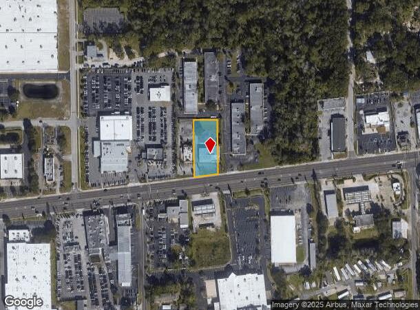
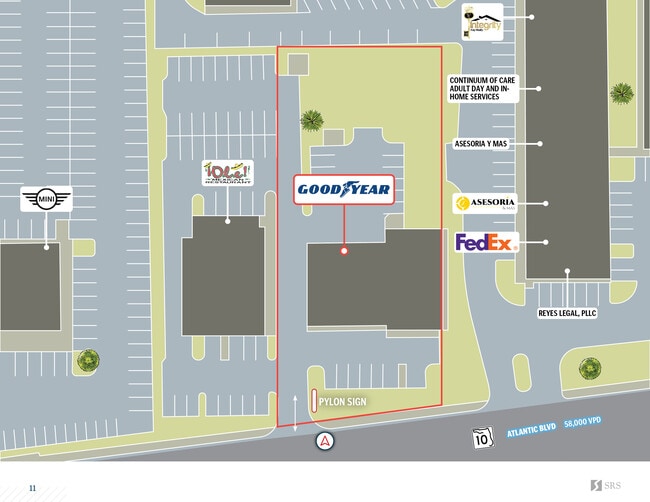
Property Record
9927 Atlantic Blvd, Jacksonville, FL 32225
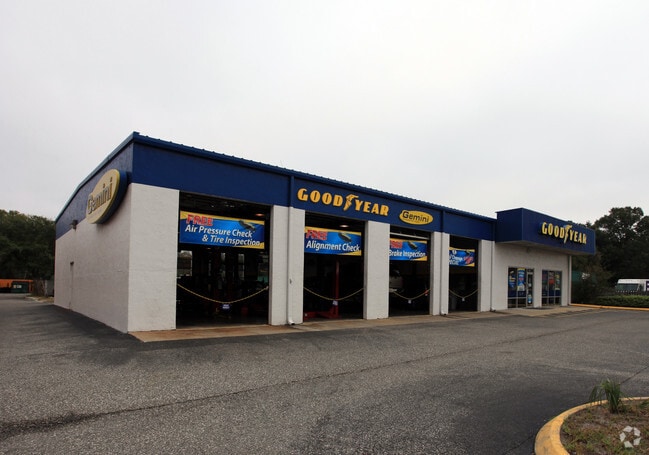
This Property Is For Sale
NEARBY LISTINGS FOR SALE OR LEASE
Property Detail
9927 Atlantic Blvd
Jacksonville, FL
Section Land
165258-0010
19-2S-28E .72 PT GOVT LOT 5,PT GOVT LOT 16 IN 18-2S-28E RECD O/R 20348-191
Servicestation
Duval
X
Florida
12031C0383H
5,16
2024
0.73 AC
2025
Arlington
014604
Jacksonville (Florida)
6,585 SF
DEMOGRAPHICS near 9927 Atlantic Blvd
1 Mile
3 Mile
5 Mile
2024 Total Population
8,994
83,783
216,159
2029 Population
9,496
87,534
225,211
Pop Growth 2024-2029
+ 5.58%
+ 4.48%
+ 4.19%
Average Age
37
37
38
2024 Total Households
3,944
32,702
85,591
HH Growth 2024-2029
+ 5.76%
+ 4.57%
+ 4.28%
Median Household Inc
$40,287
$53,515
$62,705
Avg Household Size
2.20
2.50
2.40
2024 Avg HH Vehicles
1.00
2.00
2.00
Median Home Value
$186,262
$200,694
$242,694
Median Year Built
1981
1984
1986
Nearby Places
- Restaurants
- Banks
- Shops
- Fitness
- Groceries
PUBLIC TRANSPORTATION
AIRPORT
Jacksonville International
DRIVE
WALK
Distance
Jacksonville International
28 min
18.7 mi
Freight Ports
Jacksonville Port
DRIVE
WALK
Distance
Jacksonville Port
15 min
8.7 mi
Nearby Properties
Address
Land Use
TOTAL SIZE
Lot Size
Zoning
Address
Land Use
TOTAL SIZE
Lot Size
Zoning
361,268 SF
15.27 AC
PUD
Address
Land Use
TOTAL SIZE
Lot Size
Zoning
565,202 SF
34.03 AC
RMD-D
Address
Land Use
TOTAL SIZE
Lot Size
Zoning
327,165 SF
25 AC
RMD-D
Address
Land Use
TOTAL SIZE
Lot Size
Zoning
557,032 SF
40.06 AC
PUD
Address
Land Use
TOTAL SIZE
Lot Size
Zoning
304,922 SF
26.28 AC
PUD
Address
Land Use
TOTAL SIZE
Lot Size
Zoning
430,668 SF
27.20 AC
RMD-D
Address
Land Use
TOTAL SIZE
Lot Size
Zoning
266,120 SF
14.60 AC
PUD
Address
Land Use
TOTAL SIZE
Lot Size
Zoning
321,335 SF
19.83 AC
RMD-D
Address
Land Use
TOTAL SIZE
Lot Size
Zoning
323,318 SF
19.24 AC
PUD
Address
Land Use
TOTAL SIZE
Lot Size
Zoning
471,372 SF
1,071.38 AC
PUD
Address
Land Use
TOTAL SIZE
Lot Size
Zoning
302,406 SF
20.54 AC
RMD-D
Address
Land Use
TOTAL SIZE
Lot Size
Zoning
232,520 SF
12.37 AC
RMD-D
Address
Land Use
TOTAL SIZE
Lot Size
Zoning
300,396 SF
14.44 AC
RMD-C
Address
Land Use
TOTAL SIZE
Lot Size
Zoning
184,563 SF
125.66 AC
PBF-1
Address
Land Use
TOTAL SIZE
Lot Size
Zoning
210,913 SF
10.32 AC
PUD
Address
Land Use
TOTAL SIZE
Lot Size
Zoning
210,829 SF
11.84 AC
RMD-D
Address
Land Use
TOTAL SIZE
Lot Size
Zoning
154,382 SF
8.67 AC
RMD-D
Address
Land Use
TOTAL SIZE
Lot Size
Zoning
166,588 SF
10.40 AC
RMD-D
Address
Land Use
TOTAL SIZE
Lot Size
Zoning
196,639 SF
17.44 AC
RMD-C
Address
Land Use
TOTAL SIZE
Lot Size
Zoning
164,330 SF
9.04 AC
PUD
Address
Land Use
TOTAL SIZE
Lot Size
Zoning
214,460 SF
19.77 AC
RMD-C
Address
Land Use
TOTAL SIZE
Lot Size
Zoning
125,088 SF
6.62 AC
RMD-D
Address
Land Use
TOTAL SIZE
Lot Size
Zoning
267,103 SF
17.31 AC
RMD-C
Address
Land Use
TOTAL SIZE
Lot Size
Zoning
84,088 SF
12.07 AC
PUD
Address
Land Use
TOTAL SIZE
Lot Size
Zoning
171,731 SF
17.56 AC
RMD-D
Address
Land Use
TOTAL SIZE
Lot Size
Zoning
116,814 SF
11.77 AC
RMD-D
Address
Land Use
TOTAL SIZE
Lot Size
Zoning
115,628 SF
6.26 AC
CRO
Address
Land Use
TOTAL SIZE
Lot Size
Zoning
180,528 SF
10.57 AC
RMD-D
Address
Land Use
TOTAL SIZE
Lot Size
Zoning
121,290 SF
12.25 AC
PUD
Address
Land Use
TOTAL SIZE
Lot Size
Zoning
245,531 SF
17.37 AC
CCG-1
The World's #1 Commercial Real Estate Marketplace
Connect with us
© 2025 CoStar Group
The information above has been obtained from sources believed reliable. While we do not doubt its accuracy we have not verified it and make no guarantee, warranty or representation about it. It is your responsibility to independently confirm its accuracy and completeness. Any projections, opinions, assumptions, or estimates used are for example only and do not represent the current or future performance of the property. The value of this transaction to you depends on tax and other factors which should be evaluated by your tax, financial, and legal advisors. You and your advisors should conduct a careful, independent investigation of the property to determine to your satisfaction the suitability of the property for your needs.