Property Record
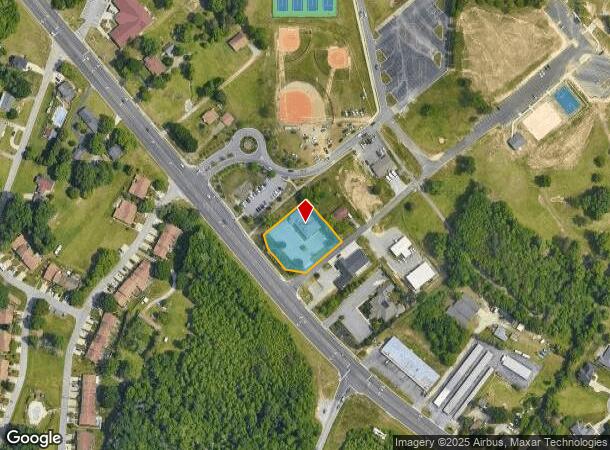
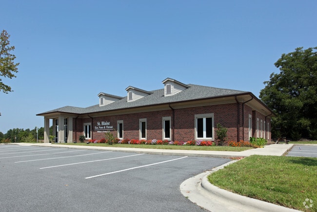
9936 Us Highway 311, High Point, NC 27263

NEARBY LISTINGS FOR SALE OR LEASE
Property Detail
9936 Us Highway 311
Greensboro-High Point, NC
Byerly
7728-20-7508
BYERLY;PT L33-39 PL:PB2-PG49
Medicalbuilding
Randolph
X
North Carolina
3710772800K
33-39
2025
0.75 AC
2025
NW Randolph Cnty/Archdale
031504
Greensboro/Winston-Salem
4,521 SF
DEMOGRAPHICS near 9936 Us Highway 311
1 Mile
3 Mile
5 Mile
2024 Total Population
3,171
18,099
37,223
2029 Population
3,263
18,609
38,117
Pop Growth 2024-2029
+ 2.90%
+ 2.82%
+ 2.40%
Average Age
43
43
41
2024 Total Households
1,255
7,421
14,986
HH Growth 2024-2029
+ 2.87%
+ 2.82%
+ 2.40%
Median Household Inc
$72,822
$60,410
$56,416
Avg Household Size
2.50
2.40
2.40
2024 Avg HH Vehicles
3.00
2.00
2.00
Median Home Value
$187,601
$158,349
$153,254
Median Year Built
1985
1979
1977
Nearby Places
Map Layers
Map Styles
 Street
 Aerial
- Restaurants
- Banks
- Shops
- Fitness
- Groceries
PUBLIC TRANSPORTATION
COMMUTER RAIL
High Point Station (Piedmont - North Carolina by Train (NC Train))
DRIVE
WALK
Distance
High Point Station (Piedmont - North Carolina by Train (NC Train))
12 min
6.5 mi
AIRPORT
Piedmont Triad International
DRIVE
WALK
Distance
Piedmont Triad International
32 min
21.5 mi
Freight Ports
Port of Wilmington
DRIVE
WALK
Distance
Port of Wilmington
242 min
204.6 mi
SALE & LEASE HISTORY
LISTING DATE
SALE/LEASE

Mar 13, 2017
For Lease
Mar 13, 2017
For Sale
Feb 22, 2017
For Sale
Nearby Properties
Address
Land Use
TOTAL SIZE
Lot Size
Zoning
Address
Land Use
TOTAL SIZE
Lot Size
Zoning
127,800 SF
57.35 AC
M-1
Address
Land Use
TOTAL SIZE
Lot Size
Zoning
159,944 SF
13.95 AC
RS-40
Address
Land Use
TOTAL SIZE
Lot Size
Zoning
299,394 SF
8.60 AC
M-2
Address
Land Use
TOTAL SIZE
Lot Size
Zoning
90,000 SF
15.36 AC
M-2
Address
Land Use
TOTAL SIZE
Lot Size
Zoning
7,680 SF
9.95 AC
GRD
Address
Land Use
TOTAL SIZE
Lot Size
Zoning
69,094 SF
5.47 AC
M-2
Address
Land Use
TOTAL SIZE
Lot Size
Zoning
28.20 AC
RR
Address
Land Use
TOTAL SIZE
Lot Size
Zoning
7,168 SF
7.51 AC
GRD
Address
Land Use
TOTAL SIZE
Lot Size
Zoning
45,224 SF
8.03 AC
OI
Address
Land Use
TOTAL SIZE
Lot Size
Zoning
73,658 SF
8.45 AC
B-1
Address
Land Use
TOTAL SIZE
Lot Size
Zoning
199,250 SF
54.80 AC
M-1
Address
Land Use
TOTAL SIZE
Lot Size
Zoning
48,913 SF
2.25 AC
B-1
Address
Land Use
TOTAL SIZE
Lot Size
Zoning
47,822 SF
5.76 AC
SU R-10
Address
Land Use
TOTAL SIZE
Lot Size
Zoning
35,620 SF
5.47 AC
M-2
Address
Land Use
TOTAL SIZE
Lot Size
Zoning
53,520 SF
5.48 AC
B-1
Address
Land Use
TOTAL SIZE
Lot Size
Zoning
8,927 SF
3.60 AC
OI
Address
Land Use
TOTAL SIZE
Lot Size
Zoning
40,275 SF
2.31 AC
B-1
Address
Land Use
TOTAL SIZE
Lot Size
Zoning
42,112 SF
6.41 AC
HB
Address
Land Use
TOTAL SIZE
Lot Size
Zoning
99,722 SF
38.11 AC
M-2
Address
Land Use
TOTAL SIZE
Lot Size
Zoning
43,328 SF
2.11 AC
B-1
Address
Land Use
TOTAL SIZE
Lot Size
Zoning
37,680 SF
1.66 AC
CD HB
Address
Land Use
TOTAL SIZE
Lot Size
Zoning
18.23 AC
R-15
Address
Land Use
TOTAL SIZE
Lot Size
Zoning
17,966 SF
4.17 AC
RBO-CD
Address
Land Use
TOTAL SIZE
Lot Size
Zoning
27,601 SF
8.28 AC
SU R-10
Address
Land Use
TOTAL SIZE
Lot Size
Zoning
22,202 SF
2.30 AC
B-1
Address
Land Use
TOTAL SIZE
Lot Size
Zoning
19,156 SF
2.33 AC
B-1
Address
Land Use
TOTAL SIZE
Lot Size
Zoning
2,880 SF
2.91 AC
B-1
Address
Land Use
TOTAL SIZE
Lot Size
Zoning
107,400 SF
9.89 AC
LI
Address
Land Use
TOTAL SIZE
Lot Size
Zoning
1.33 AC
B-1
Address
Land Use
TOTAL SIZE
Lot Size
Zoning
112,900 SF
6.39 AC
M-2
The World's #1 Commercial Real Estate Marketplace
Connect with us
© 2025 CoStar Group
The information above has been obtained from sources believed reliable. While we do not doubt its accuracy we have not verified it and make no guarantee, warranty or representation about it. It is your responsibility to independently confirm its accuracy and completeness. Any projections, opinions, assumptions, or estimates used are for example only and do not represent the current or future performance of the property. The value of this transaction to you depends on tax and other factors which should be evaluated by your tax, financial, and legal advisors. You and your advisors should conduct a careful, independent investigation of the property to determine to your satisfaction the suitability of the property for your needs.