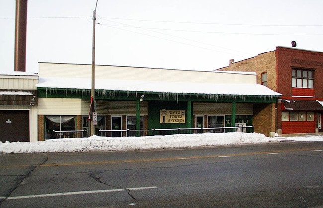
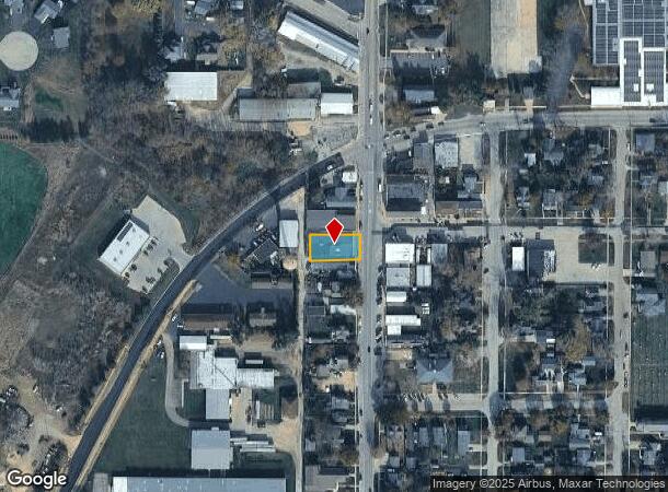
Property Record
9937 Main St, Hebron, IL 60034
NEARBY LISTINGS FOR SALE OR LEASE
-
-
View all Hebron listings for sale on LoopNet.com
Property Detail
9937 Main St
Chicago-Naperville-Elgin, IL-IN
M W Merrys Et Al Addn Vill Of Hebron
03-17-227-008
DOC 2019R0013534 N 67FT LT 5 M W MERRYS ET AL ADDN VILL OF HEBRON
Industrialgeneral
McHenry
X
Illinois
55127C0460E
5
2024
0.20 AC
2024
Far Northwest
870103
Chicago
DEMOGRAPHICS near 9937 Main St
1 Mile
3 Mile
5 Mile
2024 Total Population
1,367
1,794
2,921
2029 Population
1,359
1,785
2,914
Pop Growth 2024-2029
(0.59%)
(0.50%)
(0.24%)
Average Age
40
41
43
2024 Total Households
537
707
1,154
HH Growth 2024-2029
(0.74%)
(0.57%)
(0.35%)
Median Household Inc
$68,021
$70,861
$75,636
Avg Household Size
2.50
2.50
2.50
2024 Avg HH Vehicles
2.00
2.00
2.00
Median Home Value
$174,399
$187,978
$234,197
Median Year Built
1974
1974
1974
Nearby Places
Map Layers
Map Styles
 Street
 Aerial
- Restaurants
- Banks
- Shops
- Fitness
- Groceries
Nearby Properties
Address
Land Use
TOTAL SIZE
Lot Size
Zoning
Address
Land Use
TOTAL SIZE
Lot Size
Zoning
106.35 AC
A1
Address
Land Use
TOTAL SIZE
Lot Size
Zoning
199.60 AC
A1
Address
Land Use
TOTAL SIZE
Lot Size
Zoning
48.23 AC
A1
Address
Land Use
TOTAL SIZE
Lot Size
Zoning
Address
Land Use
TOTAL SIZE
Lot Size
Zoning
94.95 AC
A1
Address
Land Use
TOTAL SIZE
Lot Size
Zoning
2.53 AC
Address
Land Use
TOTAL SIZE
Lot Size
Zoning
1.29 AC
Address
Land Use
TOTAL SIZE
Lot Size
Zoning
2 AC
Address
Land Use
TOTAL SIZE
Lot Size
Zoning
1.77 AC
Address
Land Use
TOTAL SIZE
Lot Size
Zoning
Address
Land Use
TOTAL SIZE
Lot Size
Zoning
4.55 AC
Address
Land Use
TOTAL SIZE
Lot Size
Zoning
1.83 AC
Address
Land Use
TOTAL SIZE
Lot Size
Zoning
1.10 AC
Address
Land Use
TOTAL SIZE
Lot Size
Zoning
2.56 AC
Address
Land Use
TOTAL SIZE
Lot Size
Zoning
5.40 AC
Address
Land Use
TOTAL SIZE
Lot Size
Zoning
160.98 AC
A1
Address
Land Use
TOTAL SIZE
Lot Size
Zoning
180 AC
C1
Address
Land Use
TOTAL SIZE
Lot Size
Zoning
3.18 AC
Address
Land Use
TOTAL SIZE
Lot Size
Zoning
157.46 AC
A1
Address
Land Use
TOTAL SIZE
Lot Size
Zoning
72.95 AC
C1
Address
Land Use
TOTAL SIZE
Lot Size
Zoning
57.65 AC
A1
Address
Land Use
TOTAL SIZE
Lot Size
Zoning
70.87 AC
A1
Address
Land Use
TOTAL SIZE
Lot Size
Zoning
1.83 AC
Address
Land Use
TOTAL SIZE
Lot Size
Zoning
1.30 AC
Address
Land Use
TOTAL SIZE
Lot Size
Zoning
2.27 AC
Address
Land Use
TOTAL SIZE
Lot Size
Zoning
1.79 AC
Address
Land Use
TOTAL SIZE
Lot Size
Zoning
0.79 AC
Address
Land Use
TOTAL SIZE
Lot Size
Zoning
Address
Land Use
TOTAL SIZE
Lot Size
Zoning
1.22 AC
Address
Land Use
TOTAL SIZE
Lot Size
Zoning
0.51 AC
The World's #1 Commercial Real Estate Marketplace
Connect with us
© 2026 CoStar Group
The information above has been obtained from sources believed reliable. While we do not doubt its accuracy we have not verified it and make no guarantee, warranty or representation about it. It is your responsibility to independently confirm its accuracy and completeness. Any projections, opinions, assumptions, or estimates used are for example only and do not represent the current or future performance of the property. The value of this transaction to you depends on tax and other factors which should be evaluated by your tax, financial, and legal advisors. You and your advisors should conduct a careful, independent investigation of the property to determine to your satisfaction the suitability of the property for your needs.