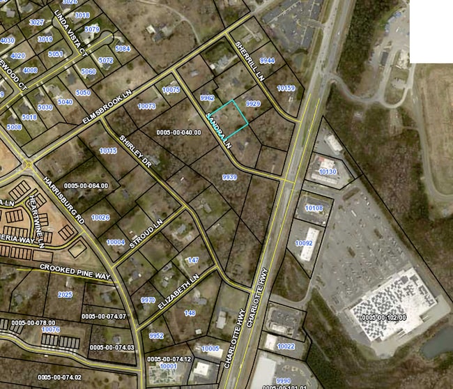
Property Record
9938 Sandra Ln, Fort Mill, SC 29707

NEARBY LISTINGS FOR SALE OR LEASE
-
-
-
-
No Photo
-
-
-
-
View all Fort Mill listings for sale on LoopNet.com
Property Detail
9938 Sandra Ln
Charlotte-Concord-Gastonia, NC-SC
Elmsbrook Sub
0005-00-028.01
Lancaster
Sfr
South Carolina
X
1.06 AC
45057C0040E
Lancaster County
1,796 SF
Charlotte
DEMOGRAPHICS near 9938 Sandra Ln
1 Mile
3 Mile
5 Mile
2024 Total Population
6,025
60,755
146,052
2029 Population
7,026
67,445
160,863
Pop Growth 2024-2029
+ 16.61%
+ 11.01%
+ 10.14%
Average Age
38
37
39
2024 Total Households
2,375
21,943
54,238
HH Growth 2024-2029
+ 16.55%
+ 11.11%
+ 10.05%
Median Household Inc
$119,128
$125,926
$115,319
Avg Household Size
2.50
2.70
2.70
2024 Avg HH Vehicles
2.00
2.00
2.00
Median Home Value
$334,051
$433,693
$413,385
Median Year Built
2010
2005
2002
Nearby Places
Map Layers
Map Styles
 Street
 Aerial
- Restaurants
- Banks
- Shops
- Fitness
- Groceries
PUBLIC TRANSPORTATION
AIRPORT
Charlotte/Douglas International
DRIVE
WALK
Distance
Charlotte/Douglas International
30 min
17.6 mi
Concord-Padgett Regional
DRIVE
WALK
Distance
Concord-Padgett Regional
48 min
38.8 mi
SALE & LEASE HISTORY
LISTING DATE
SALE/LEASE

Jun 08, 2021
For Sale
Nearby Properties
Address
Land Use
TOTAL SIZE
Lot Size
Zoning
Address
Land Use
TOTAL SIZE
Lot Size
Zoning
425,591 SF
31.58 AC
MX1
Address
Land Use
TOTAL SIZE
Lot Size
Zoning
465,462 SF
23.76 AC
CC
Address
Land Use
TOTAL SIZE
Lot Size
Zoning
480,041 SF
4.76 AC
Address
Land Use
TOTAL SIZE
Lot Size
Zoning
294,279 SF
27.77 AC
R12MFCD
Address
Land Use
TOTAL SIZE
Lot Size
Zoning
215,600 SF
6.97 AC
R3
Address
Land Use
TOTAL SIZE
Lot Size
Zoning
3,183 SF
3.82 AC
Address
Land Use
TOTAL SIZE
Lot Size
Zoning
324,188 SF
51.13 AC
Address
Land Use
TOTAL SIZE
Lot Size
Zoning
348,409 SF
26.08 AC
R17MFCD
Address
Land Use
TOTAL SIZE
Lot Size
Zoning
287,004 SF
14.52 AC
R3
Address
Land Use
TOTAL SIZE
Lot Size
Zoning
321,129 SF
23.59 AC
MX2
Address
Land Use
TOTAL SIZE
Lot Size
Zoning
293,128 SF
22.70 AC
MX2
Address
Land Use
TOTAL SIZE
Lot Size
Zoning
497,462 SF
5.64 AC
BPCD
Address
Land Use
TOTAL SIZE
Lot Size
Zoning
497,462 SF
6.32 AC
BPCD
Address
Land Use
TOTAL SIZE
Lot Size
Zoning
353,996 SF
58.49 AC
R3
Address
Land Use
TOTAL SIZE
Lot Size
Zoning
195,262 SF
4.56 AC
Address
Land Use
TOTAL SIZE
Lot Size
Zoning
186,651 SF
7.40 AC
CC
Address
Land Use
TOTAL SIZE
Lot Size
Zoning
201,638 SF
7.44 AC
R-12PUD
Address
Land Use
TOTAL SIZE
Lot Size
Zoning
254,527 SF
9.34 AC
MX2
Address
Land Use
TOTAL SIZE
Lot Size
Zoning
234,912 SF
11.60 AC
R3
Address
Land Use
TOTAL SIZE
Lot Size
Zoning
221,152 SF
15.87 AC
MX2
Address
Land Use
TOTAL SIZE
Lot Size
Zoning
157,468 SF
15.84 AC
CC
Address
Land Use
TOTAL SIZE
Lot Size
Zoning
226,602 SF
13.89 AC
BPCD
Address
Land Use
TOTAL SIZE
Lot Size
Zoning
211,609 SF
6.91 AC
UR2CD
Address
Land Use
TOTAL SIZE
Lot Size
Zoning
170,443 SF
13.77 AC
MUDD-O
Address
Land Use
TOTAL SIZE
Lot Size
Zoning
269,684 SF
0.64 AC
CC
Address
Land Use
TOTAL SIZE
Lot Size
Zoning
182,180 SF
7.31 AC
MX2
Address
Land Use
TOTAL SIZE
Lot Size
Zoning
160,395 SF
34.25 AC
R3
Address
Land Use
TOTAL SIZE
Lot Size
Zoning
121,812 SF
13.92 AC
CC
Address
Land Use
TOTAL SIZE
Lot Size
Zoning
137,210 SF
4.52 AC
Address
Land Use
TOTAL SIZE
Lot Size
Zoning
90,466 SF
105.72 AC
INST
The World's #1 Commercial Real Estate Marketplace
Connect with us
© 2026 CoStar Group
The information above has been obtained from sources believed reliable. While we do not doubt its accuracy we have not verified it and make no guarantee, warranty or representation about it. It is your responsibility to independently confirm its accuracy and completeness. Any projections, opinions, assumptions, or estimates used are for example only and do not represent the current or future performance of the property. The value of this transaction to you depends on tax and other factors which should be evaluated by your tax, financial, and legal advisors. You and your advisors should conduct a careful, independent investigation of the property to determine to your satisfaction the suitability of the property for your needs.