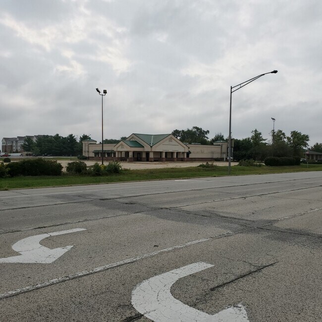
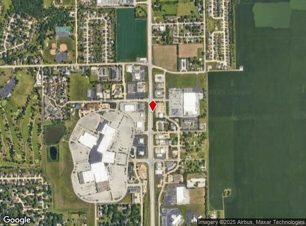
Property Record
990 S Route 51, Forsyth, IL 62535
NEARBY LISTINGS FOR SALE OR LEASE
Property Detail
990 S Route 51
07-07-14-351-006
PT SW SW-BEG 52.26 E SW COR ~N412.64 NE192.49 SE41.33 ~SE42.79 S355.31 SW250.02POB~& (EX HWY ROW) & (EX RD ROW)~02BK3269/728
Restaurantbuilding
Macon
X
Illinois
17115C0187E
2.31 AC
0
Springfield/Decatur
2024
Other Market Areas
002901
Decatur, IL
DEMOGRAPHICS near 990 S Route 51
1 Mile
3 Mile
5 Mile
2024 Total Population
2,179
15,858
39,112
2029 Population
2,088
15,226
38,130
Pop Growth 2024-2029
(4.18%)
(3.99%)
(2.51%)
Average Age
44
43
41
2024 Total Households
881
6,987
17,054
HH Growth 2024-2029
(4.31%)
(4.06%)
(2.63%)
Median Household Inc
$86,088
$48,051
$41,490
Avg Household Size
2.40
2.10
2.20
2024 Avg HH Vehicles
2.00
2.00
2.00
Median Home Value
$237,280
$143,735
$93,849
Median Year Built
1991
1975
1968
Nearby Places
Map Layers
Map Styles
 Street
 Aerial
- Restaurants
- Banks
- Shops
- Fitness
- Groceries
SALE & LEASE HISTORY
LISTING DATE
SALE/LEASE

Oct 05, 2020
For Sale
Nearby Properties
Address
Land Use
TOTAL SIZE
Lot Size
Zoning
Address
Land Use
TOTAL SIZE
Lot Size
Zoning
12.21 AC
MUNICIPAL
Address
Land Use
TOTAL SIZE
Lot Size
Zoning
207,420 SF
12.41 AC
MUNICIPAL
Address
Land Use
TOTAL SIZE
Lot Size
Zoning
1,604 SF
12.80 AC
MUNICIPAL
Address
Land Use
TOTAL SIZE
Lot Size
Zoning
3.88 AC
MUNICIPAL
Address
Land Use
TOTAL SIZE
Lot Size
Zoning
13.92 AC
MUNICIPAL
Address
Land Use
TOTAL SIZE
Lot Size
Zoning
12.24 AC
MUNICIPAL
Address
Land Use
TOTAL SIZE
Lot Size
Zoning
3.42 AC
MUNICIPAL
Address
Land Use
TOTAL SIZE
Lot Size
Zoning
23.56 AC
MUNICIPAL
Address
Land Use
TOTAL SIZE
Lot Size
Zoning
3.72 AC
MUNICIPAL
Address
Land Use
TOTAL SIZE
Lot Size
Zoning
18.50 AC
MUNICIPAL
Address
Land Use
TOTAL SIZE
Lot Size
Zoning
3.55 AC
MUNICIPAL
Address
Land Use
TOTAL SIZE
Lot Size
Zoning
14.66 AC
MUNICIPAL
Address
Land Use
TOTAL SIZE
Lot Size
Zoning
16.97 AC
MUNICIPAL
Address
Land Use
TOTAL SIZE
Lot Size
Zoning
12.84 AC
MUNICIPAL
Address
Land Use
TOTAL SIZE
Lot Size
Zoning
78.13 AC
MUNICIPAL
Address
Land Use
TOTAL SIZE
Lot Size
Zoning
4.82 AC
MUNICIPAL
Address
Land Use
TOTAL SIZE
Lot Size
Zoning
2.89 AC
MUNICIPAL
Address
Land Use
TOTAL SIZE
Lot Size
Zoning
3.50 AC
MUNICIPAL
Address
Land Use
TOTAL SIZE
Lot Size
Zoning
14.73 AC
MUNICIPAL
Address
Land Use
TOTAL SIZE
Lot Size
Zoning
5.18 AC
MUNICIPAL
Address
Land Use
TOTAL SIZE
Lot Size
Zoning
7.10 AC
MUNICIPAL
Address
Land Use
TOTAL SIZE
Lot Size
Zoning
10.16 AC
MUNICIPAL
Address
Land Use
TOTAL SIZE
Lot Size
Zoning
33,016 SF
4.94 AC
MUNICIPAL
Address
Land Use
TOTAL SIZE
Lot Size
Zoning
3.38 AC
MUNICIPAL
Address
Land Use
TOTAL SIZE
Lot Size
Zoning
3.41 AC
MUNICIPAL
Address
Land Use
TOTAL SIZE
Lot Size
Zoning
2.98 AC
MUNICIPAL
Address
Land Use
TOTAL SIZE
Lot Size
Zoning
20.75 AC
MUNICIPAL
Address
Land Use
TOTAL SIZE
Lot Size
Zoning
16.66 AC
MUNICIPAL
Address
Land Use
TOTAL SIZE
Lot Size
Zoning
1.09 AC
MUNICIPAL
The World's #1 Commercial Real Estate Marketplace
Connect with us
© 2025 CoStar Group
The information above has been obtained from sources believed reliable. While we do not doubt its accuracy we have not verified it and make no guarantee, warranty or representation about it. It is your responsibility to independently confirm its accuracy and completeness. Any projections, opinions, assumptions, or estimates used are for example only and do not represent the current or future performance of the property. The value of this transaction to you depends on tax and other factors which should be evaluated by your tax, financial, and legal advisors. You and your advisors should conduct a careful, independent investigation of the property to determine to your satisfaction the suitability of the property for your needs.