Property Record
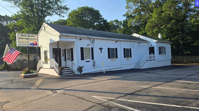
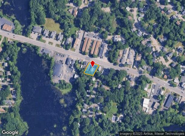
995 Washington St, East Weymouth, MA 02189
This Property Is For Sale
NEARBY LISTINGS FOR SALE OR LEASE
Property Detail
995 Washington St
WEYM-000030-000400-000004
Norfolk
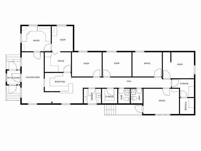
Medicalbuilding
Massachusetts
A
4
25021C0233F
0.25 AC
2025
Route 3 Corridor
2025
Boston
422303
Boston-Cambridge-Newton, MA-NH
1,580 SF
DEMOGRAPHICS near 995 Washington St
1 Mile
3 Mile
5 Mile
2024 Total Population
11,609
72,344
180,689
2029 Population
11,590
72,113
180,232
Pop Growth 2024-2029
(0.16%)
(0.32%)
(0.25%)
Average Age
41
43
42
2024 Total Households
5,225
29,807
74,177
HH Growth 2024-2029
(0.15%)
(0.32%)
(0.23%)
Median Household Inc
$77,165
$104,424
$100,448
Avg Household Size
2.10
2.40
2.40
2024 Avg HH Vehicles
1.00
2.00
2.00
Median Home Value
$427,865
$511,414
$552,278
Median Year Built
1973
1963
1963
Nearby Places
- Restaurants
- Banks
- Shops
- Fitness
- Groceries
PUBLIC TRANSPORTATION
COMMUTER RAIL
East Weymouth (Greenbush Line - Massachusetts Bay Transportation Authority Commuter Rail (Purple Line))
DRIVE
WALK
Distance
East Weymouth (Greenbush Line - Massachusetts Bay Transportation Authority Commuter Rail (Purple Line))
4 min
2.3 mi
Weymouth Landing/East Braintree (Greenbush Line - MBTA)
DRIVE
WALK
Distance
Weymouth Landing/East Braintree (Greenbush Line - MBTA)
4 min
2.5 mi
AIRPORT
General Edward Lawrence Logan International
DRIVE
WALK
Distance
General Edward Lawrence Logan International
29 min
18.4 mi
Freight Ports
Port of Boston
DRIVE
WALK
Distance
Port of Boston
26 min
16.2 mi
Nearby Properties
Address
Land Use
TOTAL SIZE
Lot Size
Zoning
Address
Land Use
TOTAL SIZE
Lot Size
Zoning
48.16 AC
Address
Land Use
TOTAL SIZE
Lot Size
Zoning
50.61 AC
IND
Address
Land Use
TOTAL SIZE
Lot Size
Zoning
31.29 AC
100
Address
Land Use
TOTAL SIZE
Lot Size
Zoning
32.04 AC
Address
Land Use
TOTAL SIZE
Lot Size
Zoning
3.65 AC
100
Address
Land Use
TOTAL SIZE
Lot Size
Zoning
33.81 AC
A3
Address
Land Use
TOTAL SIZE
Lot Size
Zoning
7.62 AC
A2
Address
Land Use
TOTAL SIZE
Lot Size
Zoning
240,481 SF
25.23 AC
CL2
Address
Land Use
TOTAL SIZE
Lot Size
Zoning
0.42 AC
A1
Address
Land Use
TOTAL SIZE
Lot Size
Zoning
172,027 SF
3.73 AC
100
Address
Land Use
TOTAL SIZE
Lot Size
Zoning
144,377 SF
9.39 AC
Address
Land Use
TOTAL SIZE
Lot Size
Zoning
18.76 AC
GBD
Address
Land Use
TOTAL SIZE
Lot Size
Zoning
11.39 AC
100
Address
Land Use
TOTAL SIZE
Lot Size
Zoning
9.78 AC
M-1
Address
Land Use
TOTAL SIZE
Lot Size
Zoning
0.23 AC
A2
Address
Land Use
TOTAL SIZE
Lot Size
Zoning
0.16 AC
Address
Land Use
TOTAL SIZE
Lot Size
Zoning
3.92 AC
R-4
Address
Land Use
TOTAL SIZE
Lot Size
Zoning
8.54 AC
100
Address
Land Use
TOTAL SIZE
Lot Size
Zoning
79,687 SF
3.52 AC
75
Address
Land Use
TOTAL SIZE
Lot Size
Zoning
2.56 AC
100
Address
Land Use
TOTAL SIZE
Lot Size
Zoning
107,410 SF
1.22 AC
85
Address
Land Use
TOTAL SIZE
Lot Size
Zoning
1.48 AC
100
Address
Land Use
TOTAL SIZE
Lot Size
Zoning
34.28 AC
85
Address
Land Use
TOTAL SIZE
Lot Size
Zoning
13.40 AC
A3
Address
Land Use
TOTAL SIZE
Lot Size
Zoning
9.56 AC
A3
Address
Land Use
TOTAL SIZE
Lot Size
Zoning
2.81 AC
A3
Address
Land Use
TOTAL SIZE
Lot Size
Zoning
154.20 AC
Address
Land Use
TOTAL SIZE
Lot Size
Zoning
3.76 AC
A3
Address
Land Use
TOTAL SIZE
Lot Size
Zoning
74,600 SF
6.29 AC
Address
Land Use
TOTAL SIZE
Lot Size
Zoning
14.55 AC
A3
The World's #1 Commercial Real Estate Marketplace
Connect with us
© 2025 CoStar Group
The information above has been obtained from sources believed reliable. While we do not doubt its accuracy we have not verified it and make no guarantee, warranty or representation about it. It is your responsibility to independently confirm its accuracy and completeness. Any projections, opinions, assumptions, or estimates used are for example only and do not represent the current or future performance of the property. The value of this transaction to you depends on tax and other factors which should be evaluated by your tax, financial, and legal advisors. You and your advisors should conduct a careful, independent investigation of the property to determine to your satisfaction the suitability of the property for your needs.